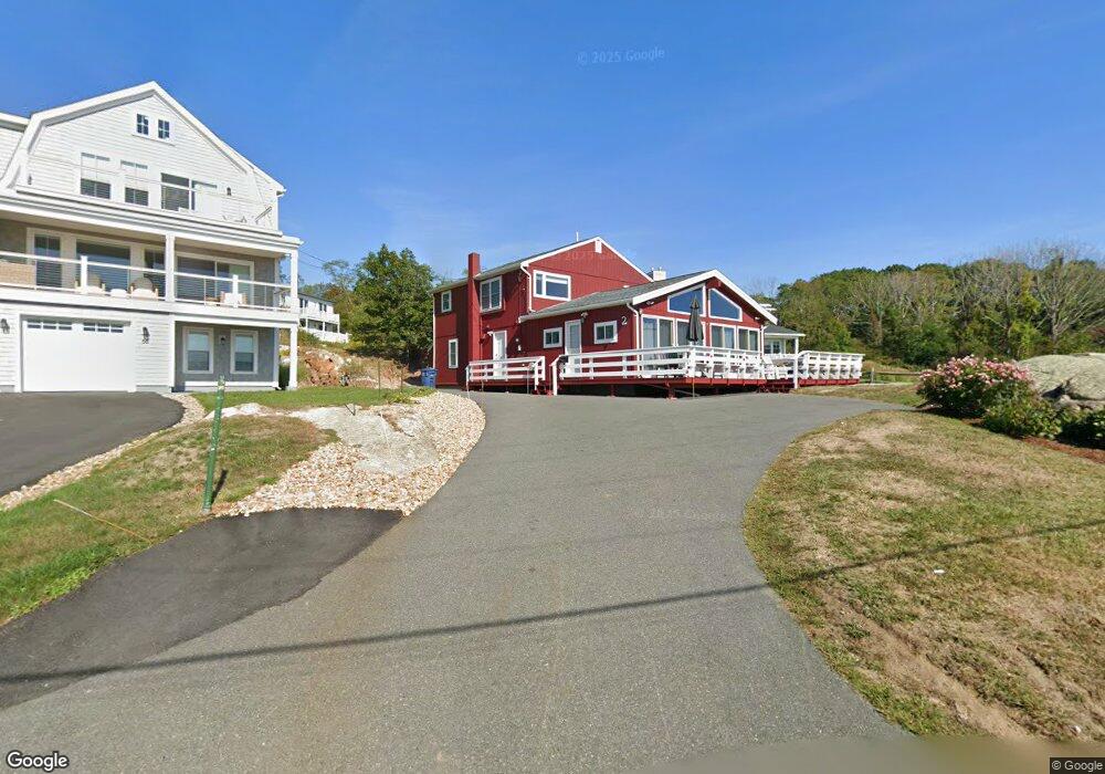
2 Eastern Point Blvd Gloucester, MA 01930
East Gloucester NeighborhoodEstimated Value: $1,333,086 - $2,177,000
4
Beds
2
Baths
2,128
Sq Ft
$801/Sq Ft
Est. Value
About This Home
This home is located at 2 Eastern Point Blvd, Gloucester, MA 01930 and is currently estimated at $1,705,522, approximately $801 per square foot. 2 Eastern Point Blvd is a home located in Essex County with nearby schools including East Gloucester Elementary School, Ralph B O'maley Middle School, and Gloucester High School.
Ownership History
Date
Name
Owned For
Owner Type
Purchase Details
Closed on
Jul 19, 2024
Sold by
Bordinaro James A and Bordinaro Jan
Bought by
2 Eastern Point Blvd Llc
Current Estimated Value
Purchase Details
Closed on
Mar 19, 2012
Sold by
Bordinaro James A
Bought by
Bordinaro James A and Bordinaro Jen
Create a Home Valuation Report for This Property
The Home Valuation Report is an in-depth analysis detailing your home's value as well as a comparison with similar homes in the area
Home Values in the Area
Average Home Value in this Area
Purchase History
| Date | Buyer | Sale Price | Title Company |
|---|---|---|---|
| 2 Eastern Point Blvd Llc | -- | None Available | |
| 2 Eastern Point Blvd Llc | -- | None Available | |
| Bordinaro James A | -- | -- | |
| Bordinaro James A | -- | -- |
Source: Public Records
Tax History
| Year | Tax Paid | Tax Assessment Tax Assessment Total Assessment is a certain percentage of the fair market value that is determined by local assessors to be the total taxable value of land and additions on the property. | Land | Improvement |
|---|---|---|---|---|
| 2025 | $11,220 | $1,154,300 | $602,200 | $552,100 |
| 2024 | $10,472 | $1,076,300 | $573,200 | $503,100 |
| 2023 | $9,877 | $932,700 | $511,800 | $420,900 |
| 2022 | $9,327 | $795,100 | $445,100 | $350,000 |
| 2021 | $8,997 | $723,200 | $404,900 | $318,300 |
| 2020 | $7,752 | $628,700 | $307,500 | $321,200 |
| 2019 | $8,034 | $633,100 | $307,500 | $325,600 |
| 2018 | $7,696 | $595,200 | $307,500 | $287,700 |
| 2017 | $7,655 | $580,400 | $292,700 | $287,700 |
| 2016 | $7,328 | $538,400 | $277,700 | $260,700 |
| 2015 | $7,239 | $530,300 | $287,300 | $243,000 |
Source: Public Records
Map
Nearby Homes
- 15 Raven Ln Unit 15
- 11 Ocean View Dr
- 10 Seaview Rd
- 73 Rocky Neck Ave Unit 2
- 197 E Main St Unit 1
- 197 E Main St Unit 2
- 30 Chapel St Unit B
- 191 Main St Unit 3
- 191 Main St Unit 2A
- 33 Middle St
- 55 Mansfield St Unit A
- 55 Mansfield St Unit B
- 55 Mansfield St
- 160 Prospect St Unit 3
- 87 Atlantic Rd Unit 2
- 20 Beacon St Unit 2
- 20 Beacon St Unit 1
- 10 Oak St Unit 3
- 113 Pleasant St
- 33 Maplewood Ave Unit 16
- 66 Eastern Point Rd
- 62 Eastern Point Rd Unit 2
- 62 Eastern Point Rd
- 62 Eastern Point Rd
- 62 Eastern Point Rd Unit WINTER
- 62 Eastern Point Rd Unit 1
- 62 Eastern Point Rd Unit 4
- 62 Eastern Point Rd Unit 3
- 64 Eastern Point Rd Unit 1
- 4 & 6 Eastern Point Blvd
- 62 Eastern Point Rd Unit WINTER
- 3 Daventry Ln Unit B
- 1 Eastern Point Blvd
- 1 Eastern Point Blvd Unit 1
- 1 Eastern Point Blvd Unit 3
- 1 Eastern Point Blvd Unit 2
- 1 Eastern Point Blvd Unit 4
- 2 Daventry Ln Unit A
- 3B Locust Ln
- 1 Locust Ln
Your Personal Tour Guide
Ask me questions while you tour the home.