Estimated Value: $818,000 - $1,189,131
7
Beds
4
Baths
3,038
Sq Ft
$343/Sq Ft
Est. Value
About This Home
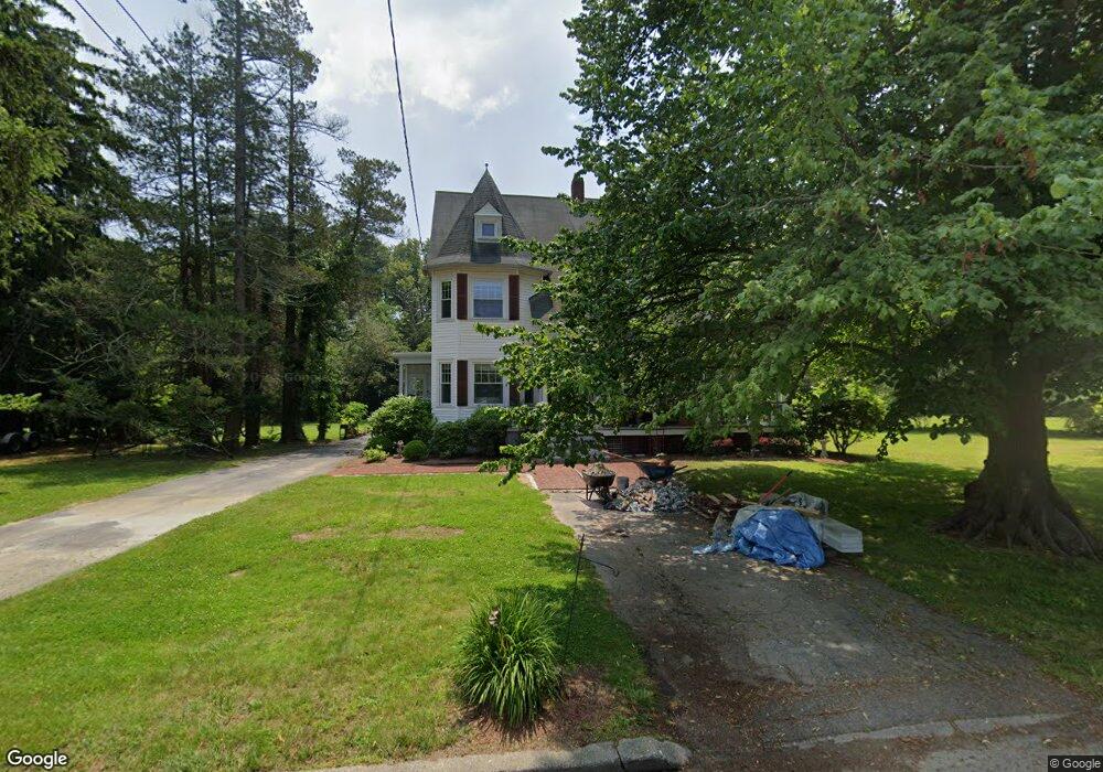
This home is located at 2 Low Ln, Bristol, RI 02809 and is currently estimated at $1,043,033, approximately $343 per square foot. 2 Low Ln is a home located in Bristol County with nearby schools including Mt. Hope High School, Our Lady of Mt. Carmel School, and St. Philomena School of the Sacred Heart.
Ownership History
Date
Name
Owned For
Owner Type
Purchase Details
Closed on
Mar 13, 2014
Sold by
Almeida James and Cehelsky Elizabeth
Bought by
Almeida David
Current Estimated Value
Purchase Details
Closed on
Jun 8, 2005
Sold by
Almeida Alice
Bought by
Almeida David and Almeida Karen J
Home Financials for this Owner
Home Financials are based on the most recent Mortgage that was taken out on this home.
Original Mortgage
$375,000
Interest Rate
5.79%
Mortgage Type
Purchase Money Mortgage
Create a Home Valuation Report for This Property
The Home Valuation Report is an in-depth analysis detailing your home's value as well as a comparison with similar homes in the area
Home Values in the Area
Average Home Value in this Area
Purchase History
| Date | Buyer | Sale Price | Title Company |
|---|---|---|---|
| Almeida David | $325,000 | -- | |
| Almeida David | $500,000 | -- |
Source: Public Records
Mortgage History
| Date | Status | Borrower | Loan Amount |
|---|---|---|---|
| Previous Owner | Almeida David | $100,000 | |
| Previous Owner | Almeida David | $375,000 |
Source: Public Records
Tax History
| Year | Tax Paid | Tax Assessment Tax Assessment Total Assessment is a certain percentage of the fair market value that is determined by local assessors to be the total taxable value of land and additions on the property. | Land | Improvement |
|---|---|---|---|---|
| 2025 | $9,443 | $683,300 | $376,600 | $306,700 |
| 2024 | $9,443 | $683,300 | $376,600 | $306,700 |
| 2023 | $9,129 | $683,300 | $376,600 | $306,700 |
| 2022 | $8,883 | $683,300 | $376,600 | $306,700 |
| 2021 | $8,248 | $573,600 | $278,400 | $295,200 |
| 2020 | $8,071 | $573,600 | $278,400 | $295,200 |
| 2019 | $7,870 | $573,600 | $278,400 | $295,200 |
| 2018 | $9,925 | $645,300 | $325,800 | $319,500 |
| 2017 | $8,727 | $584,900 | $305,400 | $279,500 |
| 2016 | $8,639 | $584,900 | $305,400 | $279,500 |
Source: Public Records
Map
Nearby Homes
- 9 Hope St
- 88 Burton St
- 22 Maple Dr
- 221 Hope St Unit 2
- 44 Wimbledon Cir
- 423 Hope St Unit 1A
- 236 State St
- 78 State St
- 18 State St Unit 5 (3rd Floor East)
- 102 Easton Ave
- 0 S Harbor (10h) Dr S
- 44 Bradford St Unit 49
- 310 Common Fence Point Blvd
- 15 Bourne St
- 45 Corys Ct
- 35 Corys Ct
- 32 Massasoit Ave
- 30 Massasoit Ave
- 2 Chilton St
- 2 Wilson St
- 3 Low Ln
- 0 Low Ln
- 8 Low Ln
- 5 Low Ln
- 4 Monkey Wrench Ln
- 0 King - Lot 1 Unit 73153417
- 45 Ferry Rd
- 7 Fish Hawk Ln
- 14 Low Ln
- 17 Fish Hawk Ln
- 6 Monkey Wrench Ln
- 3 Monkey Wrench Ln
- 47 Ferry Rd
- 20 Low Ln
- 7 Monkey Wrench Ln
- 11 Monkey Wrench Ln
- 0 Monkey Wrench Ln
- 9 Monkey Wrench Ln
- 30 Monkey Wrench Ln
- 28 Monkey Wrench Ln
Your Personal Tour Guide
Ask me questions while you tour the home.