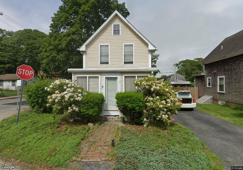
2 Maple St Wareham, MA 02571
Estimated Value: $408,366 - $593,000
3
Beds
1
Bath
1,408
Sq Ft
$364/Sq Ft
Est. Value
About This Home
This home is located at 2 Maple St, Wareham, MA 02571 and is currently estimated at $513,092, approximately $364 per square foot. 2 Maple St is a home.
Ownership History
Date
Name
Owned For
Owner Type
Purchase Details
Closed on
May 5, 2010
Sold by
Martin Michael A
Bought by
Martin Michael A and Martin Marybeth
Current Estimated Value
Purchase Details
Closed on
May 13, 1999
Sold by
Brangan Douglas C and Brangan Debra L
Bought by
Martin Michael A
Home Financials for this Owner
Home Financials are based on the most recent Mortgage that was taken out on this home.
Original Mortgage
$72,000
Interest Rate
6.92%
Mortgage Type
Purchase Money Mortgage
Purchase Details
Closed on
Jul 31, 1997
Sold by
Patricelli Michele J
Bought by
Brangan Douglas C and Brangan Debra L
Create a Home Valuation Report for This Property
The Home Valuation Report is an in-depth analysis detailing your home's value as well as a comparison with similar homes in the area
Purchase History
| Date | Buyer | Sale Price | Title Company |
|---|---|---|---|
| Martin Michael A | -- | -- | |
| Martin Michael A | -- | -- | |
| Martin Michael A | $90,000 | -- | |
| Martin Michael A | $90,000 | -- | |
| Brangan Douglas C | $69,000 | -- | |
| Brangan Douglas C | $69,000 | -- |
Source: Public Records
Mortgage History
| Date | Status | Borrower | Loan Amount |
|---|---|---|---|
| Previous Owner | Brangan Douglas C | $88,000 | |
| Previous Owner | Brangan Douglas C | $25,000 | |
| Previous Owner | Brangan Douglas C | $72,000 |
Source: Public Records
Tax History
| Year | Tax Paid | Tax Assessment Tax Assessment Total Assessment is a certain percentage of the fair market value that is determined by local assessors to be the total taxable value of land and additions on the property. | Land | Improvement |
|---|---|---|---|---|
| 2025 | $3,713 | $338,200 | $98,000 | $240,200 |
| 2024 | $3,814 | $326,500 | $73,700 | $252,800 |
| 2023 | $3,356 | $297,100 | $67,000 | $230,100 |
| 2022 | $3,356 | $246,400 | $67,000 | $179,400 |
| 2021 | $3,095 | $221,100 | $67,000 | $154,100 |
| 2020 | $2,939 | $214,400 | $67,000 | $147,400 |
| 2019 | $2,721 | $200,700 | $60,100 | $140,600 |
| 2018 | $2,522 | $179,600 | $60,100 | $119,500 |
| 2017 | $2,511 | $179,600 | $60,100 | $119,500 |
| 2016 | $2,304 | $163,500 | $57,200 | $106,300 |
| 2015 | $2,203 | $160,800 | $57,200 | $103,600 |
| 2014 | $2,453 | $184,600 | $63,500 | $121,100 |
Source: Public Records
Map
Nearby Homes
- 36B Starboard Dr Unit 36E
- 36B Starboard Dr Unit 36G
- 36B Starboard Dr Unit 36C
- 36B Starboard Dr Unit 36A
- 36B Starboard Dr Unit 36D
- 36B Starboard Dr Unit 36B
- 36B Starboard Dr Unit 36F
- 36B Starboard Dr Unit 36H
- 3 Carleton St Unit 3
- 32 Carleton St Unit 32
- 23 Starboard Dr Unit Lot 50
- 35 Locust St
- 35 Locust St
- 0 Broad St Off Unit 72362523
- 10 East Blvd
- 10 East Blvd
- 38 Amos Way
- 12 Beacon St Unit 84
- 26 Highland Ave
- 10 Beacon St Unit 83
- 6 Maple St Unit Seasonal
- 6 Maple St Unit 6
- 6 Maple St
- 6 Maple St
- 125 Onset Ave
- 5 Nanumett St
- 121 Onset Ave
- 119 Onset Ave
- 8 Maple St
- 106 Onset Ave
- 116 Onset Ave
- 116 Onset Ave Unit F
- 114 Onset Ave Unit A
- 114 Onset Ave Unit 1
- 6 Nanumett St
- 6 Nanumett St Unit n/a
- 5 Cameron St
- 5 Maple St
- 117 Onset Ave
- 5 Maple St
Your Personal Tour Guide
Ask me questions while you tour the home.