Estimated Value: $653,000 - $705,000
3
Beds
2
Baths
1,866
Sq Ft
$360/Sq Ft
Est. Value
About This Home
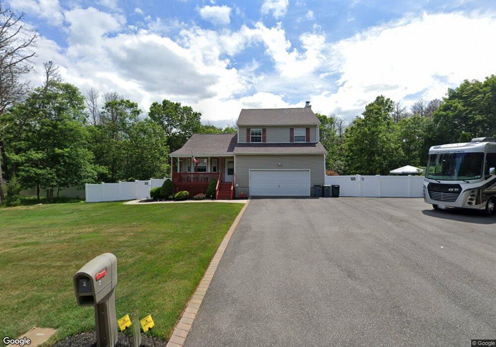
This home is located at 2 Patrick Ln, Ridge, NY 11961 and is currently estimated at $670,838, approximately $359 per square foot. 2 Patrick Ln is a home located in Suffolk County with nearby schools including Longwood Junior High School, Longwood Middle School, and Longwood Senior High School.
Ownership History
Date
Name
Owned For
Owner Type
Purchase Details
Closed on
Jul 19, 1999
Sold by
Dovale William
Bought by
Kirk Donna M and Grant Ann Regina
Current Estimated Value
Home Financials for this Owner
Home Financials are based on the most recent Mortgage that was taken out on this home.
Original Mortgage
$154,800
Outstanding Balance
$43,532
Interest Rate
7.61%
Mortgage Type
FHA
Estimated Equity
$627,306
Purchase Details
Closed on
Dec 5, 1996
Sold by
Continental Construction Corp
Bought by
Dovale William
Create a Home Valuation Report for This Property
The Home Valuation Report is an in-depth analysis detailing your home's value as well as a comparison with similar homes in the area
Home Values in the Area
Average Home Value in this Area
Purchase History
| Date | Buyer | Sale Price | Title Company |
|---|---|---|---|
| Kirk Donna M | $159,500 | Fidelity National Title Ins | |
| Dovale William | $83,000 | First American Title Ins Co |
Source: Public Records
Mortgage History
| Date | Status | Borrower | Loan Amount |
|---|---|---|---|
| Open | Kirk Donna M | $154,800 |
Source: Public Records
Tax History Compared to Growth
Tax History
| Year | Tax Paid | Tax Assessment Tax Assessment Total Assessment is a certain percentage of the fair market value that is determined by local assessors to be the total taxable value of land and additions on the property. | Land | Improvement |
|---|---|---|---|---|
| 2024 | $12,860 | $2,900 | $300 | $2,600 |
| 2023 | $12,860 | $2,900 | $300 | $2,600 |
| 2022 | $10,711 | $2,900 | $300 | $2,600 |
| 2021 | $10,711 | $2,900 | $300 | $2,600 |
| 2020 | $10,953 | $2,900 | $300 | $2,600 |
| 2019 | $10,953 | $0 | $0 | $0 |
| 2018 | $10,249 | $2,900 | $300 | $2,600 |
| 2017 | $10,249 | $2,900 | $300 | $2,600 |
| 2016 | $10,139 | $2,900 | $300 | $2,600 |
| 2015 | -- | $2,900 | $300 | $2,600 |
| 2014 | -- | $2,900 | $300 | $2,600 |
Source: Public Records
Map
Nearby Homes
- 10 Patrick Ln
- 11 Patrick Ln
- 418 Randall Rd
- 33 Highview Ln
- 28 Francis Mooney Dr
- 19 Cedar Ridge Dr
- 349 Randall Rd
- 7 Highview Ln
- 40 Ridge Haven Dr
- 0 Elizabeth Way Unit KEY803253
- Lot 39 Fox Run Ct
- 53 Ridge Haven Dr
- 193 Berkshire Dr
- 10 Sally Ln
- 8 Woodbrook Dr
- 323 Brownfield Dr
- 324 Brownfield Dr
- 38 Pond Ln
- 30 Elizabeth Way
- 201 Kingston Dr
- 1 Patrick Ln
- 6 Patrick Ln
- 0 William Floyd Pkwy Unit 3236365
- 0 William Floyd Pkwy Unit 3206630
- 5 Patrick Ln
- 20 Hay Rd
- 7 Patrick Ln
- 7 Farmhouse Dr
- 9 Farmhouse Dr
- 5 Farmhouse Dr
- 9 Patrick Ln
- 11 Farmhouse Dr
- 2114 William Floyd Pkwy
- 15 Farmhouse Dr
- 1 Farmhouse Dr
- 8 Farmhouse Dr
- 10 Farmhouse Dr
- 12 Farmhouse Dr
- 14 Patrick Ln
- 6 Farmhouse Dr