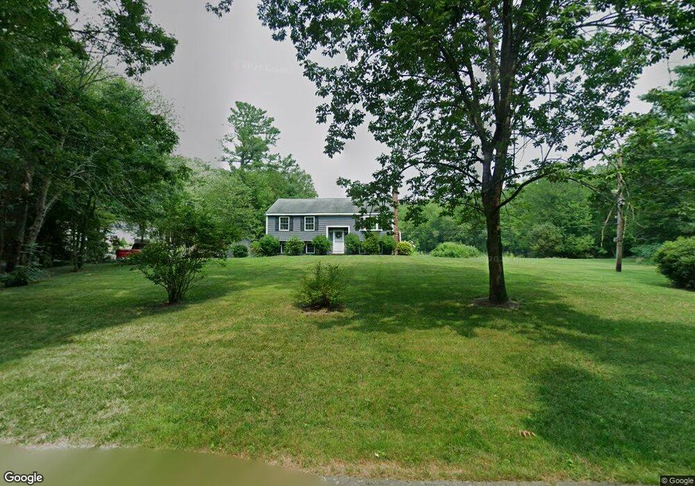
2 Taylor Ct Norton, MA 02766
Estimated Value: $546,132 - $602,000
3
Beds
1
Bath
1,120
Sq Ft
$515/Sq Ft
Est. Value
About This Home
This home is located at 2 Taylor Ct, Norton, MA 02766 and is currently estimated at $576,533, approximately $514 per square foot. 2 Taylor Ct is a home located in Bristol County with nearby schools including J.C. Solmonese Elementary School, Henri A. Yelle Elementary School, and Norton Middle School.
Ownership History
Date
Name
Owned For
Owner Type
Purchase Details
Closed on
Jul 19, 2004
Sold by
Connor Lisa A
Bought by
Skirkanich Michael O and Skirkanich Julie B
Current Estimated Value
Home Financials for this Owner
Home Financials are based on the most recent Mortgage that was taken out on this home.
Original Mortgage
$285,600
Interest Rate
6.25%
Mortgage Type
Purchase Money Mortgage
Purchase Details
Closed on
Jul 25, 1996
Sold by
Nunes Michael E and Connor Lisa A
Bought by
Connor Lisa A
Purchase Details
Closed on
Aug 28, 1992
Sold by
Michalowski John H and Michalowski Helen
Bought by
Nunes Michael E and Connor Lisa
Create a Home Valuation Report for This Property
The Home Valuation Report is an in-depth analysis detailing your home's value as well as a comparison with similar homes in the area
Home Values in the Area
Average Home Value in this Area
Purchase History
| Date | Buyer | Sale Price | Title Company |
|---|---|---|---|
| Skirkanich Michael O | $357,000 | -- | |
| Connor Lisa A | $10,000 | -- | |
| Nunes Michael E | $134,500 | -- |
Source: Public Records
Mortgage History
| Date | Status | Borrower | Loan Amount |
|---|---|---|---|
| Open | Nunes Michael E | $273,500 | |
| Closed | Skirkanich Michael O | $285,600 | |
| Previous Owner | Nunes Michael E | $35,000 | |
| Previous Owner | Nunes Michael E | $135,200 |
Source: Public Records
Tax History
| Year | Tax Paid | Tax Assessment Tax Assessment Total Assessment is a certain percentage of the fair market value that is determined by local assessors to be the total taxable value of land and additions on the property. | Land | Improvement |
|---|---|---|---|---|
| 2025 | $60 | $459,300 | $222,400 | $236,900 |
| 2024 | $5,706 | $440,600 | $211,800 | $228,800 |
| 2023 | $5,401 | $415,800 | $199,800 | $216,000 |
| 2022 | $5,251 | $368,200 | $181,600 | $186,600 |
| 2021 | $5,043 | $337,800 | $173,000 | $164,800 |
| 2020 | $4,856 | $328,100 | $167,900 | $160,200 |
| 2019 | $4,643 | $311,600 | $161,500 | $150,100 |
| 2018 | $4,540 | $299,500 | $161,500 | $138,000 |
| 2017 | $4,382 | $285,100 | $161,500 | $123,600 |
| 2016 | $4,280 | $274,200 | $161,500 | $112,700 |
| 2015 | $4,129 | $268,300 | $158,300 | $110,000 |
| 2014 | $3,952 | $257,100 | $150,800 | $106,300 |
Source: Public Records
Map
Nearby Homes
- 143 Oak St Unit 10
- 4 Village Way Unit F
- 10 Walter St
- 20 John F. Kennedy Dr
- 71 Richardson Ave
- 65 Godfrey Dr Unit 65
- 343 Godfrey Dr
- 2 Oak St Unit 2A
- 2 Oak St Unit 2B
- 95 Godfrey Dr
- 451R Gilbert St
- 2 Edgewater Dr Unit 2
- 345 Richardson Ave
- 5 Robin Cir Unit 5
- 933 Pleasant St
- 123 Pike Ave
- 157 Mansfield Ave Unit 14
- 250 Mansfield Ave Unit 11
- 180 Pike Ave
- 108 S Worcester St
Your Personal Tour Guide
Ask me questions while you tour the home.