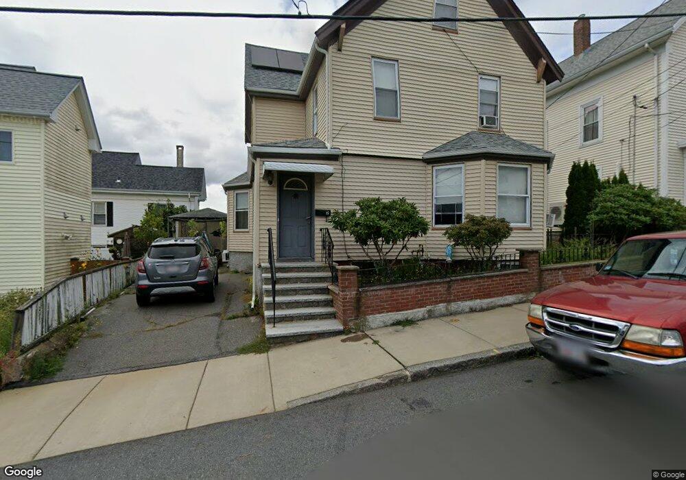
2 Trask St Gloucester, MA 01930
Central Gloucester NeighborhoodEstimated Value: $459,000 - $665,000
4
Beds
1
Bath
1,874
Sq Ft
$316/Sq Ft
Est. Value
About This Home
This home is located at 2 Trask St, Gloucester, MA 01930 and is currently estimated at $592,248, approximately $316 per square foot. 2 Trask St is a home located in Essex County with nearby schools including East Veterans Memorial Elementary, Ralph B O'maley Middle School, and Gloucester High School.
Ownership History
Date
Name
Owned For
Owner Type
Purchase Details
Closed on
May 10, 1991
Sold by
Carollo John J
Bought by
Ciolino Guiseppe
Current Estimated Value
Home Financials for this Owner
Home Financials are based on the most recent Mortgage that was taken out on this home.
Original Mortgage
$275,000
Interest Rate
9.41%
Mortgage Type
Purchase Money Mortgage
Create a Home Valuation Report for This Property
The Home Valuation Report is an in-depth analysis detailing your home's value as well as a comparison with similar homes in the area
Home Values in the Area
Average Home Value in this Area
Purchase History
| Date | Buyer | Sale Price | Title Company |
|---|---|---|---|
| Ciolino Guiseppe | $130,000 | -- |
Source: Public Records
Mortgage History
| Date | Status | Borrower | Loan Amount |
|---|---|---|---|
| Open | Ciolino Guiseppe | $150,000 | |
| Closed | Ciolino Guiseppe | $275,000 |
Source: Public Records
Tax History
| Year | Tax Paid | Tax Assessment Tax Assessment Total Assessment is a certain percentage of the fair market value that is determined by local assessors to be the total taxable value of land and additions on the property. | Land | Improvement |
|---|---|---|---|---|
| 2025 | $5,328 | $548,100 | $122,800 | $425,300 |
| 2024 | $5,277 | $542,300 | $117,000 | $425,300 |
| 2023 | $5,038 | $475,700 | $104,400 | $371,300 |
| 2022 | $4,877 | $415,800 | $90,800 | $325,000 |
| 2021 | $4,706 | $378,300 | $82,600 | $295,700 |
| 2020 | $4,660 | $377,900 | $82,600 | $295,300 |
| 2019 | $4,428 | $348,900 | $82,600 | $266,300 |
| 2018 | $4,241 | $328,000 | $82,600 | $245,400 |
| 2017 | $4,051 | $307,100 | $74,400 | $232,700 |
| 2016 | $3,860 | $283,600 | $74,300 | $209,300 |
| 2015 | $3,650 | $267,400 | $74,300 | $193,100 |
Source: Public Records
Map
Nearby Homes
- 50 Warner St
- 19 Trask St Unit 2
- 40 Sargent St
- 113 Pleasant St
- 33 Maplewood Ave Unit 310
- 12 Arthur St
- 9 Cleveland Place
- 139A Prospect St
- 98 Maplewood Ave
- 191 Main St Unit 3
- 191 Main St Unit 2A
- 8 Mystic Ave
- 13 Mystic Ave
- 120 Washington St
- 35 Middle St Unit 4
- 33 Middle St
- 36 Eastern Ave
- 6 Monroe Ct
- 20 Beacon St
- 20 Beacon St Unit 2
Your Personal Tour Guide
Ask me questions while you tour the home.