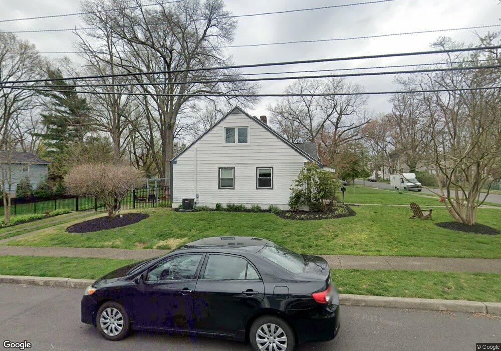
2 W Sutton Ave Moorestown, NJ 08057
Estimated Value: $361,211 - $500,000
--
Bed
--
Bath
1,026
Sq Ft
$415/Sq Ft
Est. Value
About This Home
This home is located at 2 W Sutton Ave, Moorestown, NJ 08057 and is currently estimated at $426,053, approximately $415 per square foot. 2 W Sutton Ave is a home located in Burlington County with nearby schools including Mary E. Roberts Elementary School, Moorestown Upper Elementary School, and William Allen Middle School.
Ownership History
Date
Name
Owned For
Owner Type
Purchase Details
Closed on
Dec 1, 2015
Sold by
Powell Bonnie and Maines Warren W
Bought by
Dempsey Dale and Dempsey Sara
Current Estimated Value
Purchase Details
Closed on
Jun 17, 2014
Sold by
Powelll Bonnie M and Maines Warren W
Bought by
Powell Bonnie M and Maines Warren W
Purchase Details
Closed on
Mar 10, 2010
Sold by
Maines Joseph B
Bought by
Powell Bonnie M and Maines Warren W
Purchase Details
Closed on
Sep 25, 2001
Sold by
Maines Rosalie E
Bought by
Powell Bonnie M and Maines Joseph B
Create a Home Valuation Report for This Property
The Home Valuation Report is an in-depth analysis detailing your home's value as well as a comparison with similar homes in the area
Home Values in the Area
Average Home Value in this Area
Purchase History
| Date | Buyer | Sale Price | Title Company |
|---|---|---|---|
| Dempsey Dale | $189,000 | -- | |
| Powell Bonnie M | -- | None Available | |
| Powell Bonnie M | -- | None Available | |
| Powell Bonnie M | -- | -- |
Source: Public Records
Tax History Compared to Growth
Tax History
| Year | Tax Paid | Tax Assessment Tax Assessment Total Assessment is a certain percentage of the fair market value that is determined by local assessors to be the total taxable value of land and additions on the property. | Land | Improvement |
|---|---|---|---|---|
| 2025 | $6,778 | $238,900 | $148,400 | $90,500 |
| 2024 | $6,572 | $238,900 | $148,400 | $90,500 |
| 2023 | $6,572 | $238,900 | $148,400 | $90,500 |
| 2022 | $6,505 | $238,900 | $148,400 | $90,500 |
| 2021 | $5,374 | $200,000 | $148,400 | $51,600 |
| 2020 | $5,340 | $200,000 | $148,400 | $51,600 |
| 2019 | $5,246 | $200,000 | $148,400 | $51,600 |
| 2018 | $5,104 | $200,000 | $148,400 | $51,600 |
| 2017 | $5,956 | $231,400 | $148,400 | $83,000 |
| 2016 | $5,935 | $231,400 | $148,400 | $83,000 |
| 2015 | $5,864 | $231,400 | $148,400 | $83,000 |
| 2014 | $5,567 | $231,400 | $148,400 | $83,000 |
Source: Public Records
Map
Nearby Homes
- 4 W Sutton Ave
- 2 E Sutton Ave
- 400 High St
- 336 High St
- 1 E Cooper Ave
- 404 High St
- 403 S Washington Ave
- 401 S Washington Ave
- 335 High St
- 334 High St
- 407 S Washington Ave
- 6 E Sutton Ave
- 5 E Cooper Ave
- 345 S Washington Ave
- 411 S Washington Ave
- 408 High St
- 333 High St
- 332 High St
- 341 S Washington Ave
- 417 S Washington Ave