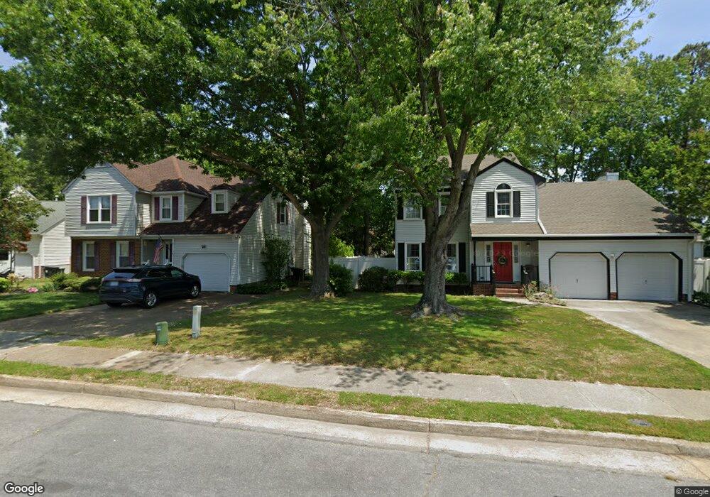
2 Watson Ln Hampton, VA 23669
Fox Hill NeighborhoodEstimated Value: $365,000 - $436,000
3
Beds
3
Baths
2,309
Sq Ft
$176/Sq Ft
Est. Value
About This Home
This home is located at 2 Watson Ln, Hampton, VA 23669 and is currently estimated at $406,390, approximately $176 per square foot. 2 Watson Ln is a home located in Hampton City with nearby schools including Phillips Elementary School, Benjamin Syms Middle School, and Kecoughtan High School.
Ownership History
Date
Name
Owned For
Owner Type
Purchase Details
Closed on
Apr 26, 2019
Sold by
Rivera Nereida
Bought by
Almodovar Anthony
Current Estimated Value
Purchase Details
Closed on
Feb 21, 2017
Sold by
Rivera Oscar R
Bought by
Rivera Nereida and Rivera Nereida
Purchase Details
Closed on
Mar 11, 2004
Sold by
Smith Ronald
Bought by
Rivera Oscar
Home Financials for this Owner
Home Financials are based on the most recent Mortgage that was taken out on this home.
Original Mortgage
$175,000
Interest Rate
5.71%
Mortgage Type
New Conventional
Create a Home Valuation Report for This Property
The Home Valuation Report is an in-depth analysis detailing your home's value as well as a comparison with similar homes in the area
Home Values in the Area
Average Home Value in this Area
Purchase History
| Date | Buyer | Sale Price | Title Company |
|---|---|---|---|
| Almodovar Anthony | -- | None Available | |
| Rivera Nereida | -- | None Available | |
| Rivera Oscar | $225,000 | -- |
Source: Public Records
Mortgage History
| Date | Status | Borrower | Loan Amount |
|---|---|---|---|
| Previous Owner | Rivera Oscar | $175,000 |
Source: Public Records
Tax History
| Year | Tax Paid | Tax Assessment Tax Assessment Total Assessment is a certain percentage of the fair market value that is determined by local assessors to be the total taxable value of land and additions on the property. | Land | Improvement |
|---|---|---|---|---|
| 2025 | $5,039 | $462,700 | $87,800 | $374,900 |
| 2024 | $4,507 | $391,900 | $87,800 | $304,100 |
| 2023 | $3,743 | $322,700 | $87,800 | $234,900 |
| 2022 | $3,559 | $301,600 | $71,500 | $230,100 |
| 2021 | $3,348 | $259,500 | $65,000 | $194,500 |
| 2020 | $3,209 | $258,800 | $65,000 | $193,800 |
| 2019 | $3,107 | $250,600 | $65,000 | $185,600 |
| 2018 | $3,178 | $248,700 | $65,000 | $183,700 |
| 2017 | $3,178 | $0 | $0 | $0 |
| 2016 | $3,178 | $248,700 | $0 | $0 |
| 2015 | $3,178 | $0 | $0 | $0 |
| 2014 | $3,346 | $248,700 | $65,000 | $183,700 |
Source: Public Records
Map
Nearby Homes
- 1777 Old Buckroe Rd
- 475 Fox Hill Rd
- 709 Whitney Ct
- 4 Alexander Dr
- 906 Allendale Dr
- 9 Colonial Acres Dr
- 116 Pine Creek Dr
- 639 Fairfield Blvd
- 3 Kansas Ct
- 702 Kings View Ct
- 64 Glenhaven Dr
- 101 Eastlawn Dr
- 22 Camellia Ln
- 635 Kings View Ct
- 3 Travis Cir
- 702 Nottingham Dr
- 40 Angelia Way
- 619 Queens View Ct
- 142 River Walk Ct
- 156 River Walk Ct
- 614 Pelham Dr
- 8 Saint Ashley Place
- 549 Fox Hill Rd
- 6 Saint Ashley Place
- 10 Saint Ashley Place
- 545 Fox Hill Rd
- 547 Fox Hill Rd
- 4 Saint Ashley Place
- 551 Fox Hill Rd
- 557 Fox Hill Rd
- 616 Pelham Dr
- 7 Nicole Ct
- 11 Saint Ashley Place
- 2 Saint Ashley Place
- 5 Nicole Ct
- 615 Pelham Dr
- 9 Nicole Ct
- 3 Nicole Ct
- 618 Pelham Dr
- 1 Nicole Ct
Your Personal Tour Guide
Ask me questions while you tour the home.