
Seller's Agent in 2025
Jennifer Palmer
Coldwell Banker Realty - Scituate
(617) 645-9805
20 in this area
52 Total Sales
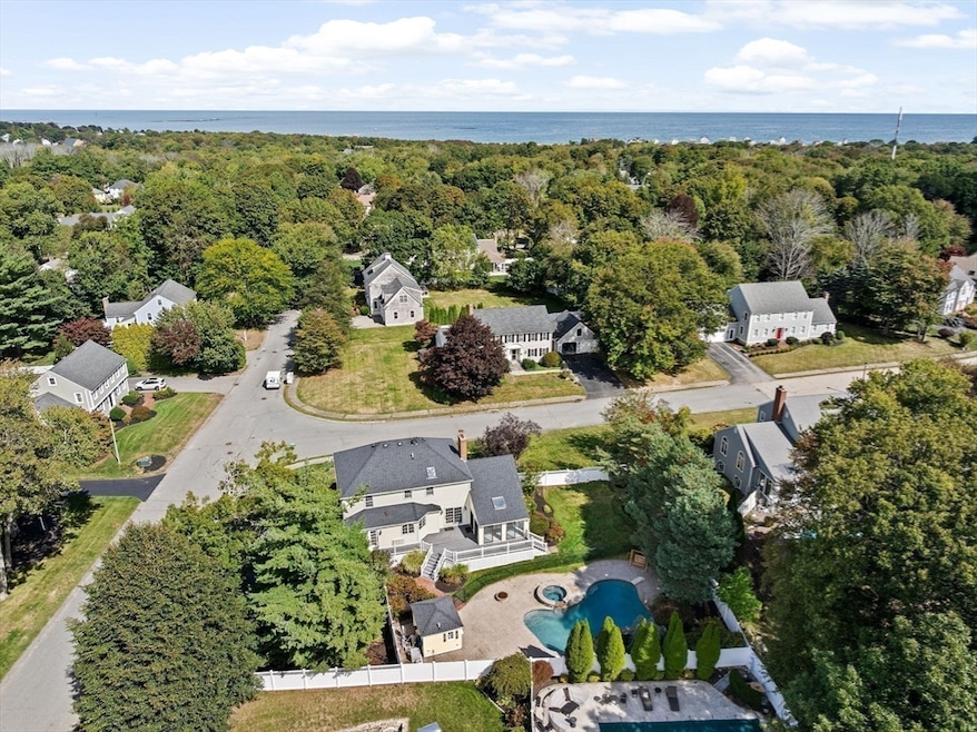
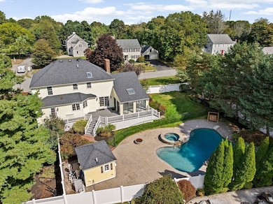
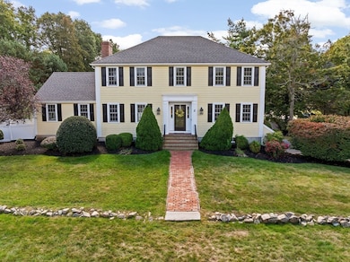
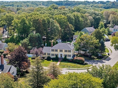
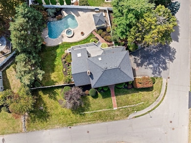
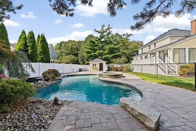
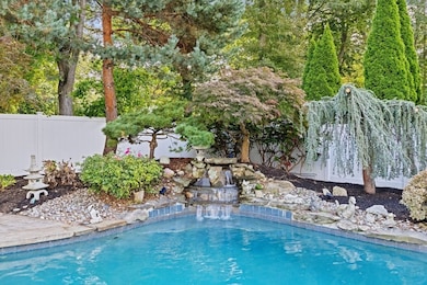
*Accepted Offer* You will fall in LOVE w this amazing 4 bd 3.5 ba classic hip-roof Colonial on a spacious corner lot in Kimberly Estates one of Scituate's most desirable + warmly loved neighborhoods. Located a 1/2 mi from Egypt Beach it's absolutely loaded w updates w/in last 5 yrs incl. new roof, furnace, water heater, AC, bathrooms, bay window, floors, fence + landscaping- all big ticket items DONE. Inside you'll be delighted w the open chef's kitchen w dining area+wet bar/coffee station, FR w cathedral ceilings+fp, light+bright sunroom w new sliders, first-floor LR/office+DR as well as new finished basement w full bath for additional rec space. Outside showcases professional landscape design w lush+colorful plantings, expansive deck, grassy fenced area for play space/pets + the centerpiece of it all a GORGEOUS heated gunite pool + hot tub w pool house. A private paradise + cherished home where lifetime memories will be made as family + friends gather to ENJOY life's special moments!
Last Agent to Sell the Property
Coldwell Banker Realty - Scituate Listed on: 09/18/2025
| Date | Type | Sale Price | Title Company |
|---|---|---|---|
| Quit Claim Deed | $1,525,000 | -- | |
| Deed | $375,000 | -- |
| Date | Status | Loan Amount | Loan Type |
|---|---|---|---|
| Open | $775,000 | New Conventional | |
| Previous Owner | $168,750 | No Value Available | |
| Previous Owner | $284,000 | No Value Available |
| Date | Event | Price | List to Sale | Price per Sq Ft |
|---|---|---|---|---|
| 12/08/2025 12/08/25 | Sold | $1,525,000 | -1.5% | $415 / Sq Ft |
| 10/23/2025 10/23/25 | Pending | -- | -- | -- |
| 10/09/2025 10/09/25 | Price Changed | $1,549,000 | -1.7% | $421 / Sq Ft |
| 09/18/2025 09/18/25 | For Sale | $1,575,000 | -- | $429 / Sq Ft |
| Year | Tax Paid | Tax Assessment Tax Assessment Total Assessment is a certain percentage of the fair market value that is determined by local assessors to be the total taxable value of land and additions on the property. | Land | Improvement |
|---|---|---|---|---|
| 2025 | $12,257 | $1,226,900 | $582,100 | $644,800 |
| 2024 | $12,036 | $1,161,800 | $529,200 | $632,600 |
| 2023 | $10,406 | $963,200 | $378,000 | $585,200 |
| 2022 | $10,406 | $824,600 | $324,700 | $499,900 |
| 2021 | $10,029 | $752,400 | $309,200 | $443,200 |
| 2020 | $9,794 | $725,500 | $297,300 | $428,200 |
| 2019 | $9,633 | $701,100 | $291,400 | $409,700 |
| 2018 | $9,324 | $668,400 | $287,200 | $381,200 |
| 2017 | $9,068 | $643,600 | $276,200 | $367,400 |
| 2016 | $9,101 | $643,600 | $276,200 | $367,400 |
| 2015 | $7,897 | $602,800 | $265,100 | $337,700 |
Seller's Agent in 2025
Jennifer Palmer
Coldwell Banker Realty - Scituate
(617) 645-9805
20 in this area
52 Total Sales
Buyer's Agent in 2025
Sandra Weston
Movementum Realty, LLC
(339) 205-4273
2 in this area
89 Total Sales
Source: MLS Property Information Network (MLS PIN)
MLS Number: 73432731
APN: 27 1 7 I
Disclaimer: Certain information contained herein is derived from information provided by parties other than Homes.com. All information provided is deemed reliable, but is not guaranteed to be accurate and should be independently verified.
![]() The property listing data and information, or the Images, set forth herein were provided to MLS Property Information Network, Inc. from third party sources, including sellers, lessors and public records, and were compiled by MLS Property Information Network, Inc. The property listing data and information, and the Images, are for the personal, non-commercial use of consumers having a good faith interest in purchasing or leasing listed properties of the type displayed to them and may not be used for any purpose other than to identify prospective properties which such consumers may have a good faith interest in purchasing or leasing. MLS Property Information Network, Inc. and its subscribers disclaim any and all representations and warranties as to the accuracy of the property listing data and information, or as to the accuracy of any of the Images, set forth herein.
The property listing data and information, or the Images, set forth herein were provided to MLS Property Information Network, Inc. from third party sources, including sellers, lessors and public records, and were compiled by MLS Property Information Network, Inc. The property listing data and information, and the Images, are for the personal, non-commercial use of consumers having a good faith interest in purchasing or leasing listed properties of the type displayed to them and may not be used for any purpose other than to identify prospective properties which such consumers may have a good faith interest in purchasing or leasing. MLS Property Information Network, Inc. and its subscribers disclaim any and all representations and warranties as to the accuracy of the property listing data and information, or as to the accuracy of any of the Images, set forth herein.
Ask me questions while you tour the home.