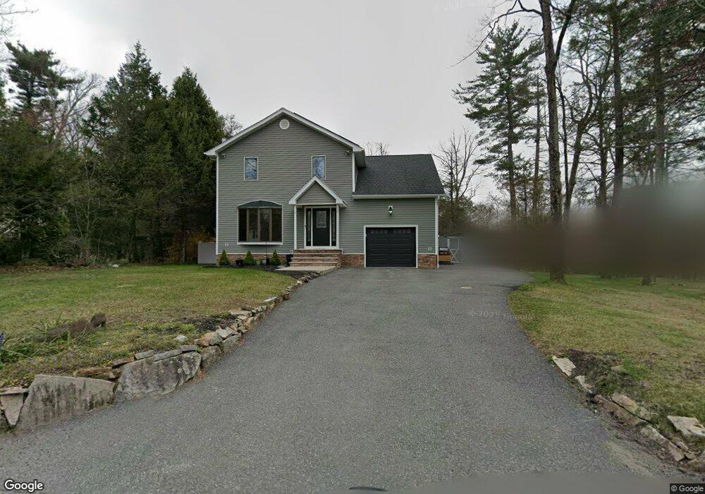
20 Barnegat Rd Hewitt, NJ 07421
Estimated Value: $501,000 - $555,000
--
Bed
--
Bath
1,872
Sq Ft
$281/Sq Ft
Est. Value
About This Home
This home is located at 20 Barnegat Rd, Hewitt, NJ 07421 and is currently estimated at $525,672, approximately $280 per square foot. 20 Barnegat Rd is a home located in Passaic County with nearby schools including Macopin Middle School and West Milford High School.
Ownership History
Date
Name
Owned For
Owner Type
Purchase Details
Closed on
Feb 10, 2009
Sold by
Deutsche Bank National Trust Co
Bought by
Macaluso Giuseppe E and Peters Stephanie M
Current Estimated Value
Home Financials for this Owner
Home Financials are based on the most recent Mortgage that was taken out on this home.
Original Mortgage
$245,471
Outstanding Balance
$154,335
Interest Rate
5%
Mortgage Type
FHA
Estimated Equity
$371,337
Purchase Details
Closed on
Sep 29, 2008
Sold by
Jerry Speziale Passaic Cnty Sheriff and Costello Barbra
Bought by
Deutsche Bank National Trust C
Purchase Details
Closed on
Jul 22, 1994
Sold by
Churchill Larry and Churchill Doreen
Bought by
Costello Gene and Costello Barbara
Home Financials for this Owner
Home Financials are based on the most recent Mortgage that was taken out on this home.
Original Mortgage
$130,000
Interest Rate
8.43%
Create a Home Valuation Report for This Property
The Home Valuation Report is an in-depth analysis detailing your home's value as well as a comparison with similar homes in the area
Home Values in the Area
Average Home Value in this Area
Purchase History
| Date | Buyer | Sale Price | Title Company |
|---|---|---|---|
| Macaluso Giuseppe E | $250,000 | -- | |
| Deutsche Bank National Trust Co | -- | -- | |
| Deutsche Bank National Trust C | $347,143 | -- | |
| Costello Gene | $170,000 | -- |
Source: Public Records
Mortgage History
| Date | Status | Borrower | Loan Amount |
|---|---|---|---|
| Open | Deutsche Bank National Trust Co | $245,471 | |
| Closed | Macaluso Giuseppe E | $245,471 | |
| Previous Owner | Costello Gene | $130,000 |
Source: Public Records
Tax History Compared to Growth
Tax History
| Year | Tax Paid | Tax Assessment Tax Assessment Total Assessment is a certain percentage of the fair market value that is determined by local assessors to be the total taxable value of land and additions on the property. | Land | Improvement |
|---|---|---|---|---|
| 2025 | $10,119 | $249,600 | $68,000 | $181,600 |
| 2024 | $10,171 | $249,600 | $68,000 | $181,600 |
| 2022 | $9,616 | $248,600 | $68,000 | $180,600 |
| 2021 | $9,410 | $248,600 | $68,000 | $180,600 |
| 2020 | $9,310 | $248,600 | $68,000 | $180,600 |
| 2019 | $9,186 | $248,600 | $68,000 | $180,600 |
| 2018 | $9,163 | $248,600 | $68,000 | $180,600 |
| 2017 | $9,206 | $248,600 | $68,000 | $180,600 |
| 2016 | $9,221 | $248,600 | $68,000 | $180,600 |
| 2015 | $9,114 | $243,600 | $68,000 | $175,600 |
| 2014 | $8,714 | $243,600 | $68,000 | $175,600 |
Source: Public Records
Map
Nearby Homes
- 67 Hanover Rd
- 4 Wyckoff Ct
- 6 Florence Rd
- 3 Neptune Rd
- 24 Caldwell Rd
- 12 Henry Rd
- 54 Shadyside Rd
- 42 Witte Rd
- 119 Lake Shore Dr
- 8 Tyler Place
- 13 Landing Rd
- 00 Jenkins Rd
- 628-630 N Lake Shore Dr
- 28 Risley Rd
- 54 Race Track Dr
- 0 Kresson Rd
- 0 Brook Rd Unit 3989068
- 00 Fairlawn Dr
- 00-1 Clinton Rd
- 109 Fairlawn Dr