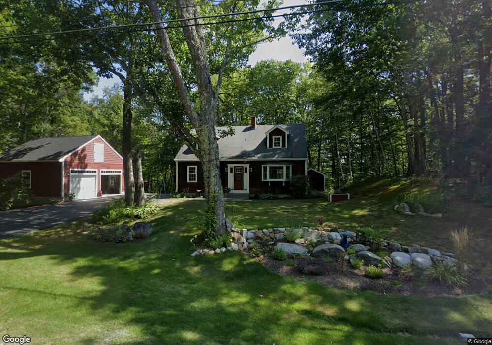
20 Carter Hill Rd Concord, NH 03303
West Concord NeighborhoodEstimated Value: $485,000 - $555,000
3
Beds
2
Baths
1,778
Sq Ft
$288/Sq Ft
Est. Value
About This Home
This home is located at 20 Carter Hill Rd, Concord, NH 03303 and is currently estimated at $511,185, approximately $287 per square foot. 20 Carter Hill Rd is a home with nearby schools including Beaver Meadow School, Rundlett Middle School, and Concord High School.
Ownership History
Date
Name
Owned For
Owner Type
Purchase Details
Closed on
Nov 1, 2018
Sold by
Brennan James P and Brennan Terri L
Bought by
Brennan 2018 Ft
Current Estimated Value
Purchase Details
Closed on
Sep 17, 1987
Bought by
Brennan James P and Brennan Terri L
Create a Home Valuation Report for This Property
The Home Valuation Report is an in-depth analysis detailing your home's value as well as a comparison with similar homes in the area
Home Values in the Area
Average Home Value in this Area
Purchase History
| Date | Buyer | Sale Price | Title Company |
|---|---|---|---|
| Brennan 2018 Ft | -- | -- | |
| Brennan James P | $138,000 | -- |
Source: Public Records
Mortgage History
| Date | Status | Borrower | Loan Amount |
|---|---|---|---|
| Previous Owner | Brennan James P | $141,000 |
Source: Public Records
Tax History Compared to Growth
Tax History
| Year | Tax Paid | Tax Assessment Tax Assessment Total Assessment is a certain percentage of the fair market value that is determined by local assessors to be the total taxable value of land and additions on the property. | Land | Improvement |
|---|---|---|---|---|
| 2024 | $8,786 | $317,300 | $124,800 | $192,500 |
| 2023 | $8,523 | $317,300 | $124,800 | $192,500 |
| 2022 | $8,215 | $317,300 | $124,800 | $192,500 |
| 2021 | $7,493 | $298,300 | $124,800 | $173,500 |
| 2020 | $7,043 | $263,200 | $95,600 | $167,600 |
| 2019 | $6,748 | $242,900 | $87,600 | $155,300 |
| 2018 | $6,430 | $228,100 | $78,600 | $149,500 |
| 2017 | $6,320 | $223,800 | $79,600 | $144,200 |
| 2016 | $5,930 | $214,300 | $79,600 | $134,700 |
| 2015 | $5,657 | $206,900 | $79,600 | $127,300 |
| 2014 | $5,547 | $206,900 | $79,600 | $127,300 |
| 2013 | $5,234 | $204,600 | $79,800 | $124,800 |
| 2012 | $5,269 | $216,200 | $79,800 | $136,400 |
Source: Public Records
Map
Nearby Homes
- 148 Broad Cove Dr
- 49 Skyline Dr
- 14 S Emperor Dr
- 3 Cabernet Dr Unit 3
- 6 K St Unit 393Z 104
- 37 Rex Dr
- 35 Callaway Dr Unit 2
- 35 Callaway Dr Unit 6
- 3 Merlot Ct Unit 4
- 13 Cheryl Dr
- 9 Duke Ln
- 3 Palm St
- 18 Dawn Dr
- 7 Currier Rd
- 282-284 N State St
- 129 Fisherville Rd Unit 4
- 129 Fisherville Rd Unit 8
- 4 Tanager Cir Unit 8
- 4 Tanager Cir Unit 7
- 4 Tanager Cir Unit 4
- 120 Lake View Dr
- 6 Carter Hill Rd
- 21 Carter Hill Rd
- 25 Carter Hill Rd
- 2 Carter Hill Rd
- 17 Villanova Dr
- 35 Carter Hill Rd
- 39 Carter Hill Rd
- 44 Carter Hill Rd
- 44 Carter Hill Rd Unit 4
- 44 Carter Hill Rd Unit 3
- 44 Carter Hill Rd Unit 2
- 44 Carter Hill Rd
- 44 Carter Hill Rd
- 30 Villanova Dr
- 45 Carter Hill Rd
- 52 Carter Hill Rd
- 12 Villanova Dr
- 58 Carter Hill Rd
- 53 Carter Hill Rd