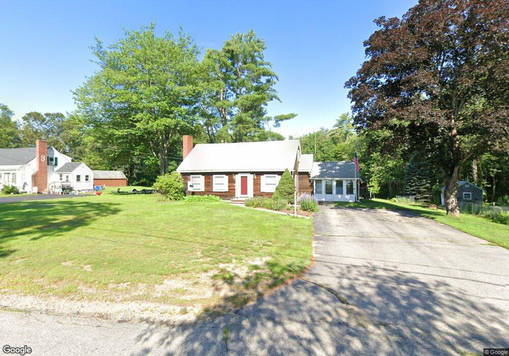
20 Clark Rd Alfred, ME 04002
Estimated Value: $260,000 - $500,000
3
Beds
2
Baths
864
Sq Ft
$470/Sq Ft
Est. Value
About This Home
This home is located at 20 Clark Rd, Alfred, ME 04002 and is currently estimated at $406,408, approximately $470 per square foot. 20 Clark Rd is a home with nearby schools including Massabesic High School.
Ownership History
Date
Name
Owned For
Owner Type
Purchase Details
Closed on
Dec 30, 2021
Sold by
Gerry Kendall A and Gerry Pamela L
Bought by
Gerry Jason E and Gerry Karlita C
Current Estimated Value
Home Financials for this Owner
Home Financials are based on the most recent Mortgage that was taken out on this home.
Original Mortgage
$152,000
Outstanding Balance
$139,513
Interest Rate
3.11%
Mortgage Type
Purchase Money Mortgage
Estimated Equity
$266,895
Create a Home Valuation Report for This Property
The Home Valuation Report is an in-depth analysis detailing your home's value as well as a comparison with similar homes in the area
Home Values in the Area
Average Home Value in this Area
Purchase History
| Date | Buyer | Sale Price | Title Company |
|---|---|---|---|
| Gerry Jason E | $169,000 | None Available |
Source: Public Records
Mortgage History
| Date | Status | Borrower | Loan Amount |
|---|---|---|---|
| Open | Gerry Jason E | $152,000 |
Source: Public Records
Tax History
| Year | Tax Paid | Tax Assessment Tax Assessment Total Assessment is a certain percentage of the fair market value that is determined by local assessors to be the total taxable value of land and additions on the property. | Land | Improvement |
|---|---|---|---|---|
| 2025 | $3,352 | $347,306 | $129,725 | $217,581 |
| 2024 | $3,282 | $347,306 | $129,725 | $217,581 |
| 2023 | $3,314 | $176,300 | $85,500 | $90,800 |
| 2022 | $3,173 | $176,300 | $85,500 | $90,800 |
| 2021 | $3,041 | $176,300 | $85,500 | $90,800 |
| 2020 | $2,891 | $176,300 | $85,500 | $90,800 |
| 2019 | $2,891 | $176,300 | $85,500 | $90,800 |
| 2018 | $112 | $176,300 | $85,500 | $90,800 |
| 2017 | $2,803 | $176,300 | $85,500 | $90,800 |
| 2016 | $2,671 | $176,300 | $85,500 | $90,800 |
| 2015 | $2,556 | $176,300 | $85,500 | $90,800 |
| 2014 | $2,512 | $176,300 | $85,500 | $90,800 |
| 2013 | $2,424 | $176,300 | $85,500 | $90,800 |
Source: Public Records
Map
Nearby Homes
- 87 Drown Rd
- 23 Branch View Terrace N
- TBD Bernier Rd
- TBD1 Bernier Rd
- 34 Cascade Cir Unit 30
- 58 Sanford Rd
- TBD Branch View Terrace Unit Lot 5
- TBD Branch View Terrace Unit Lot 4
- Lot B Bernier Rd
- Lot A Bernier Rd
- Lot 35 Bennett Rd
- 232 Waterboro Rd
- 6 Commodore Dr
- 0 Sanford Rd
- 65 Old County Rd
- 8 Hummingbird Ln
- 13 Federal St
- 16 Marcotte Ln
- 149 Duke Ln
- 32 Conifer Dr
Your Personal Tour Guide
Ask me questions while you tour the home.