Estimated Value: $687,000 - $757,000
4
Beds
3
Baths
1,820
Sq Ft
$398/Sq Ft
Est. Value
About This Home
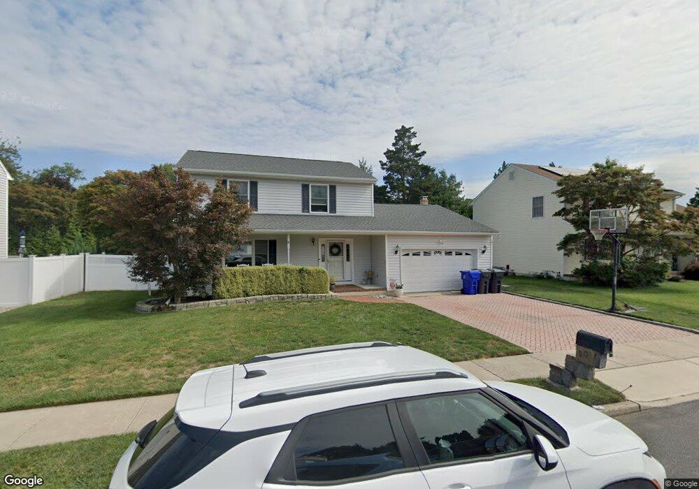
This home is located at 20 Diane Dr, Brick, NJ 08724 and is currently estimated at $724,210, approximately $397 per square foot. 20 Diane Dr is a home located in Ocean County with nearby schools including Midstreams Elementary School, Veterans Memorial Middle School, and Brick Township Memorial High School.
Ownership History
Date
Name
Owned For
Owner Type
Purchase Details
Closed on
Jan 6, 2006
Sold by
Legreide Kevin and Stolfe Abigale
Bought by
Mancini Leonard and Mancini Jennifer
Current Estimated Value
Home Financials for this Owner
Home Financials are based on the most recent Mortgage that was taken out on this home.
Original Mortgage
$388,000
Outstanding Balance
$146,962
Interest Rate
1%
Mortgage Type
Fannie Mae Freddie Mac
Estimated Equity
$577,248
Purchase Details
Closed on
Sep 22, 2003
Sold by
Ramos Jerry
Bought by
Legriede Kevin
Home Financials for this Owner
Home Financials are based on the most recent Mortgage that was taken out on this home.
Original Mortgage
$250,000
Interest Rate
6.15%
Purchase Details
Closed on
Jul 29, 1998
Sold by
Mcdermott Paul F and Mcdermott Teresa M
Bought by
Ramos Jerry and Ramos Georgina
Home Financials for this Owner
Home Financials are based on the most recent Mortgage that was taken out on this home.
Original Mortgage
$200,450
Interest Rate
6.92%
Create a Home Valuation Report for This Property
The Home Valuation Report is an in-depth analysis detailing your home's value as well as a comparison with similar homes in the area
Home Values in the Area
Average Home Value in this Area
Purchase History
| Date | Buyer | Sale Price | Title Company |
|---|---|---|---|
| Mancini Leonard | $485,000 | None Available | |
| Legriede Kevin | $342,000 | -- | |
| Ramos Jerry | $211,000 | -- |
Source: Public Records
Mortgage History
| Date | Status | Borrower | Loan Amount |
|---|---|---|---|
| Open | Mancini Leonard | $388,000 | |
| Previous Owner | Legriede Kevin | $250,000 | |
| Previous Owner | Ramos Jerry | $200,450 |
Source: Public Records
Tax History
| Year | Tax Paid | Tax Assessment Tax Assessment Total Assessment is a certain percentage of the fair market value that is determined by local assessors to be the total taxable value of land and additions on the property. | Land | Improvement |
|---|---|---|---|---|
| 2025 | $9,315 | $356,900 | $165,000 | $191,900 |
| 2024 | $8,840 | $356,900 | $165,000 | $191,900 |
Source: Public Records
Map
Nearby Homes
- 4 East Trail
- 17 East Trail
- 3 C Trail
- 1 Princeton Pines Place
- 13 Golden Rod Ct
- 74 Fairview Ave
- 36 Sleepy Hollow Dr
- 982 Falkenberg Rd
- 94 Sleepy Hollow Dr
- 241 Old Squan Rd
- 24 Davos Rd
- 209 Winchester Dr
- 53 Albert Cucci Dr
- 744 Pine Dr
- 746 Pine Dr
- 769 Pine Dr
- 56 Joseph Byrne Dr
- 106 Arrowhead Park Dr
- 140 Meridian Dr
- 14 Coolidge Dr
Your Personal Tour Guide
Ask me questions while you tour the home.