J
Seller's Agent in 2021
Jorie Fleming
Compass Massachusetts, LLC


Estimated Value: $1,124,000 - $1,490,509
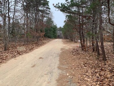
Can't find the home you're looking for? Start fresh and build exactly what you want on this acre plus lot on the ocean side in Eastham. Square footage support 4 bedrooms with plenty of room for garage or pool. Located near the bike trail and close to the Cape Cod National Seashore, Coast Guard and Nauset Light Beaches, shops and restaurants.
Last Agent to Sell the Property
Jorie Fleming
Compass Massachusetts, LLC Listed on: 01/23/2021
Last Buyer's Agent
Member Non
cci.unknownoffice
We collect this data history from publicly available records. To have your information removed, we recommend requesting removal directly through your county’s website.
| Date | Buyer | Sale Price | Title Company |
|---|---|---|---|
| Hoerle Robert F | -- | -- |
| Date | Event | Price | List to Sale | Price per Sq Ft |
|---|---|---|---|---|
| 02/26/2021 02/26/21 | Sold | $275,000 | +10.4% | -- |
| 01/28/2021 01/28/21 | Pending | -- | -- | -- |
| 01/23/2021 01/23/21 | For Sale | $249,000 | -- | -- |
| Year | Tax Paid | Tax Assessment Tax Assessment Total Assessment is a certain percentage of the fair market value that is determined by local assessors to be the total taxable value of land and additions on the property. | Land | Improvement |
|---|---|---|---|---|
| 2025 | $9,809 | $1,272,300 | $296,300 | $976,000 |
| 2024 | $4,214 | $601,100 | $287,700 | $313,400 |
| 2023 | $1,929 | $266,400 | $266,400 | $0 |
| 2022 | $2,041 | $237,900 | $237,900 | $0 |
| 2021 | $1,985 | $216,200 | $216,200 | $0 |
| 2020 | $1,924 | $220,600 | $220,600 | $0 |
| 2019 | $1,767 | $214,200 | $214,200 | $0 |
| 2018 | $1,737 | $208,000 | $208,000 | $0 |
| 2017 | $1,611 | $203,900 | $203,900 | $0 |
| 2016 | $1,517 | $203,900 | $203,900 | $0 |
| 2015 | $1,419 | $199,900 | $199,900 | $0 |
J
Seller's Agent in 2021
Jorie Fleming
Compass Massachusetts, LLC
M
Buyer's Agent in 2021
Member Non
cci.unknownoffice
Source: Cape Cod & Islands Association of REALTORS®
MLS Number: 22100314
APN: EAST-000008-000000-000052
Disclaimer: Certain information contained herein is derived from information provided by parties other than Homes.com. All information provided is deemed reliable, but is not guaranteed to be accurate and should be independently verified.
![]() All data relating to real estate for sale on this page comes from the Broker Reciprocity (BR) of the Cape Cod & Islands Multiple Listing Service, Inc. Detailed information about real estate listings held by brokerage firms other than CC&I Assoc. of REALTORS®, Inc. includes the name of the listing company. Neither the listing company nor CC&I Assoc. of REALTORS®, Inc. shall be responsible for any typographical errors, misinformation, misprints and shall be held totally harmless. The Broker providing this data believes it to be correct, but advises interested parties to confirm any item before relying on it in a purchase decision. All properties are subject to prior sale, changes, or withdrawal. Copyright 2026 © Cape Cod & Islands Multiple Listing Service, Inc. All rights reserved.
All data relating to real estate for sale on this page comes from the Broker Reciprocity (BR) of the Cape Cod & Islands Multiple Listing Service, Inc. Detailed information about real estate listings held by brokerage firms other than CC&I Assoc. of REALTORS®, Inc. includes the name of the listing company. Neither the listing company nor CC&I Assoc. of REALTORS®, Inc. shall be responsible for any typographical errors, misinformation, misprints and shall be held totally harmless. The Broker providing this data believes it to be correct, but advises interested parties to confirm any item before relying on it in a purchase decision. All properties are subject to prior sale, changes, or withdrawal. Copyright 2026 © Cape Cod & Islands Multiple Listing Service, Inc. All rights reserved.
Ask me questions while you tour the home.