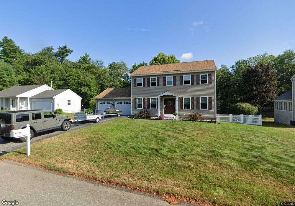
20 Freedom St Merrimack, NH 03054
Estimated Value: $622,000 - $635,000
2
Beds
3
Baths
2,305
Sq Ft
$273/Sq Ft
Est. Value
About This Home
This home is located at 20 Freedom St, Merrimack, NH 03054 and is currently estimated at $629,339, approximately $273 per square foot. 20 Freedom St is a home located in Hillsborough County with nearby schools including James Mastricola Elementary School, James Mastricola Upper Elementary School, and Merrimack Middle School.
Ownership History
Date
Name
Owned For
Owner Type
Purchase Details
Closed on
Jul 19, 1999
Sold by
Lacerte Michael P
Bought by
Hargreaves Jeffrey J and Hargreaves Lisa A
Current Estimated Value
Home Financials for this Owner
Home Financials are based on the most recent Mortgage that was taken out on this home.
Original Mortgage
$164,878
Interest Rate
7.39%
Create a Home Valuation Report for This Property
The Home Valuation Report is an in-depth analysis detailing your home's value as well as a comparison with similar homes in the area
Home Values in the Area
Average Home Value in this Area
Purchase History
| Date | Buyer | Sale Price | Title Company |
|---|---|---|---|
| Hargreaves Jeffrey J | $165,000 | -- |
Source: Public Records
Mortgage History
| Date | Status | Borrower | Loan Amount |
|---|---|---|---|
| Open | Hargreaves Jeffrey J | $150,000 | |
| Closed | Hargreaves Jeffrey J | $17,000 | |
| Closed | Hargreaves Jeffrey J | $164,878 |
Source: Public Records
Tax History Compared to Growth
Tax History
| Year | Tax Paid | Tax Assessment Tax Assessment Total Assessment is a certain percentage of the fair market value that is determined by local assessors to be the total taxable value of land and additions on the property. | Land | Improvement |
|---|---|---|---|---|
| 2024 | $8,328 | $402,500 | $173,300 | $229,200 |
| 2023 | $7,829 | $402,500 | $173,300 | $229,200 |
| 2022 | $6,995 | $402,500 | $173,300 | $229,200 |
| 2021 | $6,911 | $402,500 | $173,300 | $229,200 |
| 2020 | $7,247 | $301,200 | $141,200 | $160,000 |
| 2019 | $7,268 | $301,200 | $141,200 | $160,000 |
| 2018 | $7,265 | $301,200 | $141,200 | $160,000 |
| 2017 | $7,039 | $301,200 | $141,200 | $160,000 |
| 2016 | $6,864 | $301,200 | $141,200 | $160,000 |
| 2015 | $6,781 | $274,300 | $124,400 | $149,900 |
| 2014 | $6,608 | $274,300 | $124,400 | $149,900 |
| 2013 | $6,499 | $271,800 | $124,400 | $147,400 |
Source: Public Records
Map
Nearby Homes
- 3 Independence Dr
- 5 Fernwood Dr
- 12 Victoria Dr
- 9 Edgewood Ave
- 33 Iris Dr
- 14 Mayflower Dr
- 7 Hadley Rd
- 38 Mallard Point
- 20 Jakes Ln
- 30 Fox Meadow Ln
- 11 Essex Green Ct
- 19 Templeton Ct
- 14 Silver Doe Ln
- 1 Whitewood Ln
- 40 Captain Bannon Cir
- 11 Pondview Dr
- 49 Pondview Dr
- 29 Bedford Rd
- 343 Charles Bancroft Hwy
- 633 Daniel Webster Hwy
- 18 Freedom St
- 22 Freedom St
- 25 Hartwood Dr
- 15 Freedom St
- 17 Freedom St
- 24 Freedom St
- 27 Hartwood Dr
- 19 Freedom St
- 16 Freedom St
- 11 Freedom St
- 21 Freedom St
- 14 Freedom St
- 20 Independence Dr
- 21 Hartwood Dr
- 22 Independence Dr
- 7 Freedom St
- 1 Huckleberry Ln
- 1 Huckleberry Ln Unit 1
- 9 Freedom St
- 16 Independence Dr