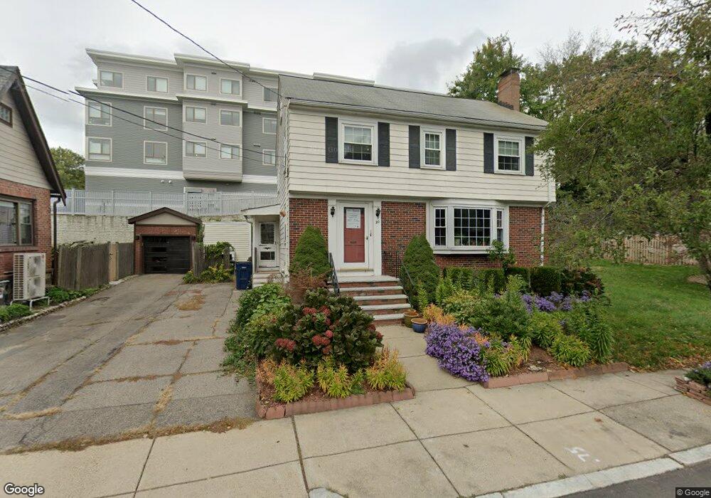
20 Hazelmere Rd Roslindale, MA 02131
Roslindale NeighborhoodEstimated Value: $842,000 - $1,153,000
3
Beds
3
Baths
2,150
Sq Ft
$466/Sq Ft
Est. Value
About This Home
This home is located at 20 Hazelmere Rd, Roslindale, MA 02131 and is currently estimated at $1,002,149, approximately $466 per square foot. 20 Hazelmere Rd is a home located in Suffolk County with nearby schools including Brooke Charter School Roslindale, Holy Name Parish School, and St. Clare High School.
Ownership History
Date
Name
Owned For
Owner Type
Purchase Details
Closed on
Jul 20, 1992
Sold by
Maher Alice A
Bought by
Lee George Y and Lee Ngei W
Current Estimated Value
Home Financials for this Owner
Home Financials are based on the most recent Mortgage that was taken out on this home.
Original Mortgage
$112,000
Interest Rate
8.54%
Mortgage Type
Purchase Money Mortgage
Create a Home Valuation Report for This Property
The Home Valuation Report is an in-depth analysis detailing your home's value as well as a comparison with similar homes in the area
Home Values in the Area
Average Home Value in this Area
Purchase History
| Date | Buyer | Sale Price | Title Company |
|---|---|---|---|
| Lee George Y | $162,000 | -- |
Source: Public Records
Mortgage History
| Date | Status | Borrower | Loan Amount |
|---|---|---|---|
| Open | Lee George Y | $130,000 | |
| Closed | Lee George Y | $100,000 | |
| Closed | Lee George Y | $112,000 |
Source: Public Records
Tax History
| Year | Tax Paid | Tax Assessment Tax Assessment Total Assessment is a certain percentage of the fair market value that is determined by local assessors to be the total taxable value of land and additions on the property. | Land | Improvement |
|---|---|---|---|---|
| 2025 | $10,170 | $878,200 | $218,800 | $659,400 |
| 2024 | $7,621 | $699,200 | $209,100 | $490,100 |
| 2023 | $7,509 | $699,200 | $209,100 | $490,100 |
| 2022 | $6,792 | $624,300 | $186,700 | $437,600 |
| 2021 | $6,545 | $613,400 | $186,700 | $426,700 |
| 2020 | $5,986 | $566,900 | $173,700 | $393,200 |
| 2019 | $5,532 | $524,900 | $146,600 | $378,300 |
| 2018 | $5,095 | $486,200 | $146,600 | $339,600 |
| 2017 | $5,149 | $486,200 | $146,600 | $339,600 |
| 2016 | $5,192 | $472,000 | $146,600 | $325,400 |
| 2015 | $5,021 | $414,600 | $144,200 | $270,400 |
| 2014 | $4,741 | $376,900 | $144,200 | $232,700 |
Source: Public Records
Map
Nearby Homes
- 87 Buchanan Rd
- 2 Weld Hill St Unit PH2
- 37 Morey Rd
- 22 Walter St Unit 2
- 79 Robert St Unit 3
- 26 Bradfield Ave Unit 3
- 7 Basto Terrace
- 206 Allandale Rd Unit 3C
- 18 Robert St Unit 4
- 103 Belgrade Ave Unit 2
- 2 Brownson Terrace
- 12 Allandale St
- 67 Risley Rd
- 118-120 Tyndale St
- 626 South St
- 281 Belgrade Ave Unit 2
- 150 Tyndale St Unit 2
- 4012 Washington St
- 19 Delford St
- 142 Birch St Unit 2
- 1400 Centre St
- 1400 Centre St Unit 400
- 1400 Centre St Unit 206
- 1400 Centre St Unit 401
- 1400 Centre St Unit 200
- 1400 Centre St Unit 305
- 1400 Centre St Unit 303
- 1400 Centre St Unit 404
- 1400 Centre St Unit 205
- 1400 Centre St Unit 203
- 1400 Centre St Unit 201
- 1400 Centre St Unit 403
- 1400 Centre St Unit 301
- 1400 Centre St Unit 202
- 1400 Centre St Unit 302
- 1400 Centre St Unit 405
- 1400 Centre St Unit 304
- 1400 Centre St Unit 402
- 1400 Centre St Unit 204
- 1400 Centre St Unit 203
Your Personal Tour Guide
Ask me questions while you tour the home.