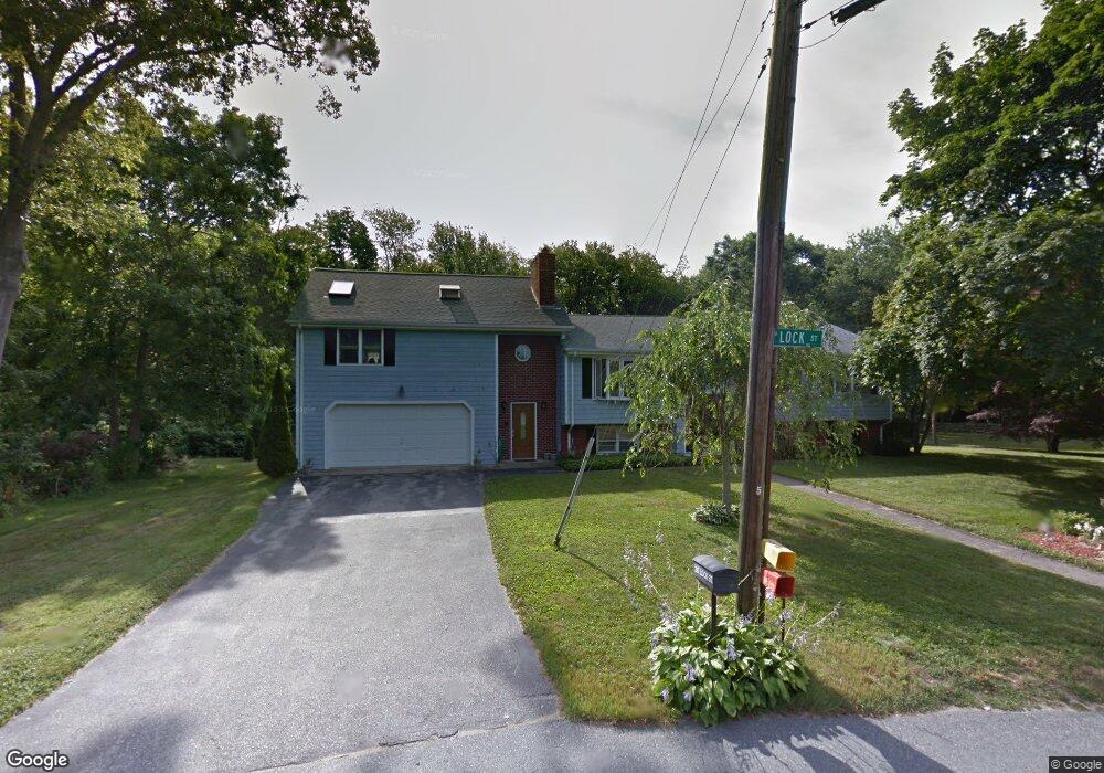
20 Lock St Tiverton, RI 02878
Bliss Corners NeighborhoodEstimated Value: $584,000 - $669,000
4
Beds
3
Baths
2,440
Sq Ft
$252/Sq Ft
Est. Value
About This Home
This home is located at 20 Lock St, Tiverton, RI 02878 and is currently estimated at $615,793, approximately $252 per square foot. 20 Lock St is a home located in Newport County with nearby schools including Tiverton High School, Atlantis Charter School, and Holy Trinity School.
Ownership History
Date
Name
Owned For
Owner Type
Purchase Details
Closed on
Aug 31, 1998
Sold by
Dryer James W and Dryer Susan
Bought by
Guerrera Donald P and Guerrera Stephanie
Current Estimated Value
Home Financials for this Owner
Home Financials are based on the most recent Mortgage that was taken out on this home.
Original Mortgage
$138,000
Interest Rate
6.9%
Mortgage Type
Purchase Money Mortgage
Purchase Details
Closed on
Jul 10, 1997
Sold by
Roussin Henry and Roussin Rita
Bought by
Dryer James W and Dryer Susan
Home Financials for this Owner
Home Financials are based on the most recent Mortgage that was taken out on this home.
Original Mortgage
$156,100
Interest Rate
7.86%
Mortgage Type
Purchase Money Mortgage
Create a Home Valuation Report for This Property
The Home Valuation Report is an in-depth analysis detailing your home's value as well as a comparison with similar homes in the area
Home Values in the Area
Average Home Value in this Area
Purchase History
| Date | Buyer | Sale Price | Title Company |
|---|---|---|---|
| Guerrera Donald P | $165,000 | -- | |
| Dryer James W | $153,000 | -- |
Source: Public Records
Mortgage History
| Date | Status | Borrower | Loan Amount |
|---|---|---|---|
| Open | Dryer James W | $126,000 | |
| Closed | Dryer James W | $12,000 | |
| Closed | Dryer James W | $138,000 | |
| Previous Owner | Dryer James W | $156,100 |
Source: Public Records
Tax History Compared to Growth
Tax History
| Year | Tax Paid | Tax Assessment Tax Assessment Total Assessment is a certain percentage of the fair market value that is determined by local assessors to be the total taxable value of land and additions on the property. | Land | Improvement |
|---|---|---|---|---|
| 2025 | $5,364 | $485,400 | $104,100 | $381,300 |
| 2024 | $5,364 | $485,400 | $104,100 | $381,300 |
| 2023 | $5,610 | $376,500 | $95,400 | $281,100 |
| 2022 | $5,508 | $376,500 | $95,400 | $281,100 |
| 2021 | $5,373 | $376,500 | $95,400 | $281,100 |
| 2020 | $5,713 | $352,900 | $83,100 | $269,800 |
| 2019 | $5,572 | $352,900 | $83,100 | $269,800 |
| 2018 | $5,784 | $352,900 | $83,100 | $269,800 |
| 2017 | $5,431 | $285,100 | $80,400 | $204,700 |
| 2016 | $5,457 | $285,100 | $80,400 | $204,700 |
| 2015 | $5,432 | $283,800 | $80,400 | $203,400 |
| 2014 | $5,207 | $269,800 | $77,200 | $192,600 |
Source: Public Records
Map
Nearby Homes
- 75 Montgomery St
- 100 Corys Ln
- 100 Cory's Ln
- 219 Tickle Rd
- 14 Glendale Ave
- 51 Newton St
- 0 Tickle Rd Unit 73453134
- 1125 Stafford Rd Unit 5
- 447 Stafford Rd Unit E7
- 447 Stafford Rd Unit E4
- 447 Stafford Rd Unit C4
- 507R Stafford Rd
- 507 Stafford Rd
- 33 Moniz Dr
- 8 Campion Ave
- 71 Blackbird St
- 3 Blackbird St
- 9 Blackbird St
- 0 Crandall Rd
- 70 Robin Dr
- 190 Montgomery St
- 150 Slade St
- 44 Captains Cir Unit 46
- 184 Montgomery St
- 155 Slade St
- 172 Montgomery St
- 211 Bridle Way
- 166 Fairwood Dr
- 20 Captains Cir
- 52 Captains Cir
- 160 Montgomery St
- 138 Slade St
- 201 Bridle Way
- 180 Fairwood Dr
- 49 Captains Cir
- 60 Captains Cir
- 29 Captains Cir
- 231 Bridle Way Unit 233
- 0 Captain's Cir Unit 1080184
- 152 Fairwood Dr