
Seller's Agent in 2025
Anne Reardon French
Re/Max Vision
(508) 868-0614
1 in this area
61 Total Sales

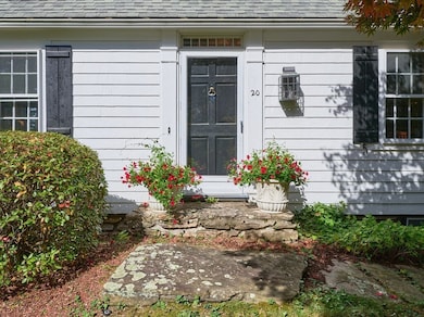
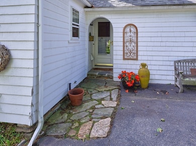
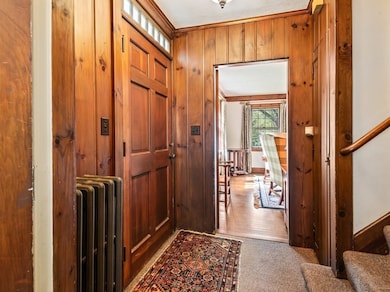

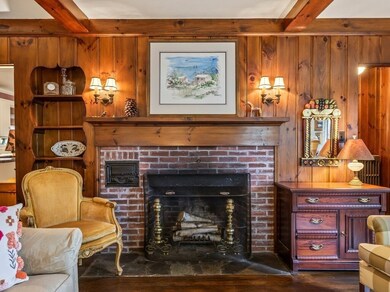
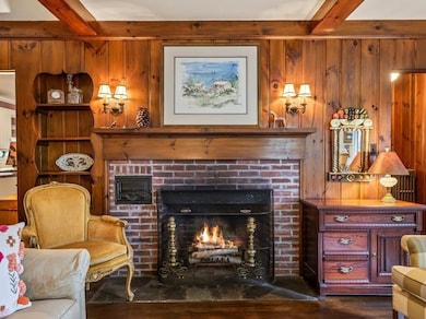
***NEW to MARKET***This 3 bedroom, 1.5 bath classic 1930's Cape will captivate both your heart & imagination! Filled with handsome details such as hardwood floors, wainscoting, crown moulding and custom built-ins, the home exudes warmth and character. The spacious living room has a wood burning fireplace accented by a wall of natural wood paneling & beamed ceiling. A formal dining room provides the perfect setting for holiday gatherings or evening meals while the adjacent eat in kitchen offers it's own attractive features such as solid wood cabinetry and a custom cherry & maple floor. The remodeled half bath includes W&D hookups allowing for a first floor laundry. The family room provides a second fireplace for cozy cold weather get togethers or enjoy the summer breezes in the adjoining screened porch. Three generous bedrooms and a full bath make up the second level. Conveniently located with easy access to Worcester's many cultural, educational & medical facilities***
Last Buyer's Agent
CJ Lee
Redfin Corp.
| Date | Type | Sale Price | Title Company |
|---|---|---|---|
| Quit Claim Deed | $462,500 | -- | |
| Deed | $162,000 | -- |
| Date | Status | Loan Amount | Loan Type |
|---|---|---|---|
| Open | $370,000 | New Conventional | |
| Previous Owner | $15,000 | No Value Available | |
| Previous Owner | $121,500 | Purchase Money Mortgage |
| Date | Event | Price | List to Sale | Price per Sq Ft |
|---|---|---|---|---|
| 12/08/2025 12/08/25 | Sold | $462,500 | -2.6% | $227 / Sq Ft |
| 10/15/2025 10/15/25 | Pending | -- | -- | -- |
| 10/04/2025 10/04/25 | For Sale | $475,000 | -- | $233 / Sq Ft |
| Year | Tax Paid | Tax Assessment Tax Assessment Total Assessment is a certain percentage of the fair market value that is determined by local assessors to be the total taxable value of land and additions on the property. | Land | Improvement |
|---|---|---|---|---|
| 2025 | $5,345 | $405,200 | $118,900 | $286,300 |
| 2024 | $5,232 | $380,500 | $118,900 | $261,600 |
| 2023 | $5,025 | $350,400 | $103,400 | $247,000 |
| 2022 | $4,616 | $303,500 | $82,700 | $220,800 |
| 2021 | $4,576 | $281,100 | $66,200 | $214,900 |
| 2020 | $4,451 | $261,800 | $66,200 | $195,600 |
| 2019 | $4,235 | $235,300 | $59,600 | $175,700 |
| 2018 | $4,245 | $224,500 | $59,600 | $164,900 |
| 2017 | $4,057 | $211,100 | $59,600 | $151,500 |
| 2016 | $4,033 | $195,700 | $44,200 | $151,500 |
| 2015 | $3,928 | $195,700 | $44,200 | $151,500 |
| 2014 | $3,824 | $195,700 | $44,200 | $151,500 |
Seller's Agent in 2025
Anne Reardon French
Re/Max Vision
(508) 868-0614
1 in this area
61 Total Sales
C
Buyer's Agent in 2025
CJ Lee
Redfin Corp.
Source: MLS Property Information Network (MLS PIN)
MLS Number: 73439639
APN: WORC-000030-000018-000143
Disclaimer: Certain information contained herein is derived from information provided by parties other than Homes.com. All information provided is deemed reliable, but is not guaranteed to be accurate and should be independently verified.
![]() The property listing data and information, or the Images, set forth herein were provided to MLS Property Information Network, Inc. from third party sources, including sellers, lessors and public records, and were compiled by MLS Property Information Network, Inc. The property listing data and information, and the Images, are for the personal, non-commercial use of consumers having a good faith interest in purchasing or leasing listed properties of the type displayed to them and may not be used for any purpose other than to identify prospective properties which such consumers may have a good faith interest in purchasing or leasing. MLS Property Information Network, Inc. and its subscribers disclaim any and all representations and warranties as to the accuracy of the property listing data and information, or as to the accuracy of any of the Images, set forth herein.
The property listing data and information, or the Images, set forth herein were provided to MLS Property Information Network, Inc. from third party sources, including sellers, lessors and public records, and were compiled by MLS Property Information Network, Inc. The property listing data and information, and the Images, are for the personal, non-commercial use of consumers having a good faith interest in purchasing or leasing listed properties of the type displayed to them and may not be used for any purpose other than to identify prospective properties which such consumers may have a good faith interest in purchasing or leasing. MLS Property Information Network, Inc. and its subscribers disclaim any and all representations and warranties as to the accuracy of the property listing data and information, or as to the accuracy of any of the Images, set forth herein.
Ask me questions while you tour the home.