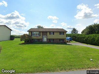
20 Maple Ln Myerstown, PA 17067
Jackson NeighborhoodEstimated Value: $269,000 - $316,000
3
Beds
2
Baths
1,720
Sq Ft
$168/Sq Ft
Est. Value
About This Home
This home is located at 20 Maple Ln, Myerstown, PA 17067 and is currently estimated at $289,568, approximately $168 per square foot. 20 Maple Ln is a home located in Lebanon County with nearby schools including Eastern Lebanon County Senior High School, Nacetown Mennonite School, and County Line School.
Ownership History
Date
Name
Owned For
Owner Type
Purchase Details
Closed on
May 3, 2023
Sold by
Smetana Michelle L and Smetana Jeffrey H
Bought by
Smetana Michelle L and Smetana Jeremy
Current Estimated Value
Home Financials for this Owner
Home Financials are based on the most recent Mortgage that was taken out on this home.
Original Mortgage
$188,237
Outstanding Balance
$183,941
Interest Rate
6.32%
Mortgage Type
FHA
Estimated Equity
$106,830
Purchase Details
Closed on
Jul 26, 2005
Sold by
Peffley Troy D
Bought by
Harnish Jeffrey H and Harnish Michelle L
Home Financials for this Owner
Home Financials are based on the most recent Mortgage that was taken out on this home.
Original Mortgage
$153,784
Interest Rate
5.54%
Mortgage Type
FHA
Create a Home Valuation Report for This Property
The Home Valuation Report is an in-depth analysis detailing your home's value as well as a comparison with similar homes in the area
Home Values in the Area
Average Home Value in this Area
Purchase History
| Date | Buyer | Sale Price | Title Company |
|---|---|---|---|
| Smetana Michelle L | -- | None Listed On Document | |
| Harnish Jeffrey H | $155,000 | None Available |
Source: Public Records
Mortgage History
| Date | Status | Borrower | Loan Amount |
|---|---|---|---|
| Open | Smetana Michelle L | $188,237 | |
| Previous Owner | Smetana Michelle L | $4,466 | |
| Previous Owner | Smetana Michelle L | $9,954 | |
| Previous Owner | Harnish Michelle L | $9,832 | |
| Previous Owner | Harnish Jeffrey H | $153,784 | |
| Previous Owner | Peffley Troy D | $80,000 |
Source: Public Records
Tax History Compared to Growth
Tax History
| Year | Tax Paid | Tax Assessment Tax Assessment Total Assessment is a certain percentage of the fair market value that is determined by local assessors to be the total taxable value of land and additions on the property. | Land | Improvement |
|---|---|---|---|---|
| 2025 | $3,421 | $151,300 | $37,000 | $114,300 |
| 2024 | $3,075 | $147,600 | $37,000 | $110,600 |
| 2023 | $3,075 | $147,600 | $37,000 | $110,600 |
| 2022 | $3,003 | $147,600 | $37,000 | $110,600 |
| 2021 | $2,862 | $147,600 | $37,000 | $110,600 |
| 2020 | $2,821 | $147,600 | $37,000 | $110,600 |
| 2019 | $2,765 | $147,600 | $37,000 | $110,600 |
| 2018 | $2,716 | $147,600 | $37,000 | $110,600 |
| 2017 | $486 | $147,600 | $37,000 | $110,600 |
| 2016 | $2,595 | $147,600 | $37,000 | $110,600 |
| 2015 | -- | $147,600 | $37,000 | $110,600 |
| 2014 | -- | $147,600 | $37,000 | $110,600 |
Source: Public Records
Map
Nearby Homes
- 446 Stracks Dam Rd
- 4 Bumblebee Ct
- 4 Ladybug Ln
- 6 Ladybug Ln
- 2 Dragonfly Ct
- 161 Oaken Way
- 111 N Ramona Rd
- 218 W Franklin Ave
- 1300 E Kercher Ave Unit 3
- 1300 E Kercher Ave
- 1300 E Kercher Ave Unit 68
- 4 Colonial Ave
- 64 Springhouse Dr
- 19 S College St
- 37 Arbor Dr
- 35 Scenic Dr
- 14 Brookside Cir
- 106 N Hoover St
- 33 Rosemont Dr
- 12 Thorndale Dr