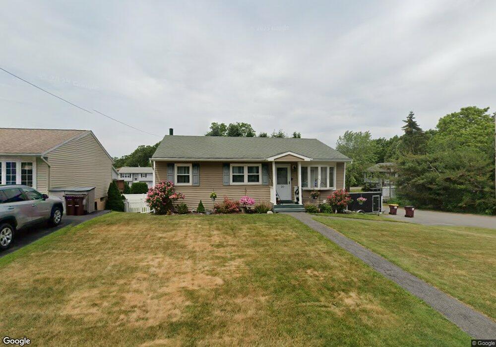
20 Mohawk Ave Latham, NY 12110
Estimated Value: $287,000 - $290,000
3
Beds
1
Bath
936
Sq Ft
$308/Sq Ft
Est. Value
About This Home
This home is located at 20 Mohawk Ave, Latham, NY 12110 and is currently estimated at $287,870, approximately $307 per square foot. 20 Mohawk Ave is a home located in Albany County with nearby schools including Forts Ferry School, Shaker Junior High School, and Shaker High School.
Ownership History
Date
Name
Owned For
Owner Type
Purchase Details
Closed on
Jul 24, 2018
Sold by
Hoffman Jason Scott
Bought by
Hoffman Melinda
Current Estimated Value
Purchase Details
Closed on
Jul 20, 2004
Sold by
Purritano Francis A
Bought by
Hoffman Jason S
Purchase Details
Closed on
Mar 7, 1996
Sold by
Ismail Mohamad
Bought by
Purritano Frances A and Purritano Glenn
Purchase Details
Closed on
Mar 6, 1992
Sold by
Bruce Michael L and Bruce Donna M
Bought by
Memon Mohammnd
Create a Home Valuation Report for This Property
The Home Valuation Report is an in-depth analysis detailing your home's value as well as a comparison with similar homes in the area
Home Values in the Area
Average Home Value in this Area
Purchase History
| Date | Buyer | Sale Price | Title Company |
|---|---|---|---|
| Hoffman Melinda | -- | None Available | |
| Hoffman Jason S | $119,000 | Donna B Heinrichs | |
| Purritano Frances A | $90,000 | -- | |
| Memon Mohammnd | $89,500 | -- |
Source: Public Records
Tax History Compared to Growth
Tax History
| Year | Tax Paid | Tax Assessment Tax Assessment Total Assessment is a certain percentage of the fair market value that is determined by local assessors to be the total taxable value of land and additions on the property. | Land | Improvement |
|---|---|---|---|---|
| 2024 | $3,722 | $84,000 | $21,000 | $63,000 |
| 2023 | $3,630 | $84,000 | $21,000 | $63,000 |
| 2022 | $3,540 | $84,000 | $21,000 | $63,000 |
| 2021 | $3,525 | $84,000 | $21,000 | $63,000 |
| 2020 | $3,121 | $84,000 | $21,000 | $63,000 |
| 2019 | $1,704 | $84,000 | $21,000 | $63,000 |
| 2018 | $2,890 | $84,000 | $21,000 | $63,000 |
| 2017 | $0 | $84,000 | $21,000 | $63,000 |
| 2016 | $2,790 | $84,000 | $21,000 | $63,000 |
| 2015 | -- | $84,000 | $21,000 | $63,000 |
| 2014 | -- | $84,000 | $21,000 | $63,000 |
Source: Public Records
Map
Nearby Homes
- 5 Marquette Ave
- 68 Green Island Ave
- 7 Colonie Ave
- 61 Latham Ridge Rd
- 2 Priddle Ln
- 447 Troy-Schenectady Rd
- 7 School St
- 10 School St
- 92 Surrey Hill Dr
- 3 Dante Terrace
- 251 Troy-Schenectady Rd
- 3 Taft Ave
- 11 Belleauwood Cir
- 52 Overlook Ave
- 42 Waterford Ave
- 44 Waterford Ave
- 15 Delta Blvd
- 105 Overlook Ave
- 521 Watervliet Shaker Rd
- 167 Harvard Rd