
Seller's Agent in 2026
Michael Gallo
Gallo Realty Group
(603) 836-0151
3 in this area
114 Total Sales
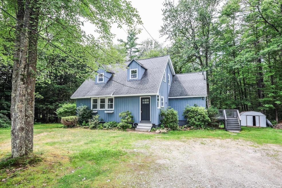
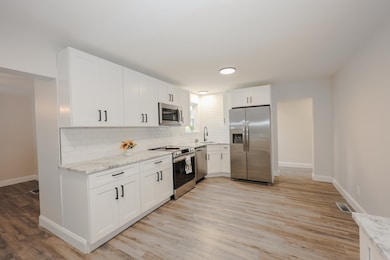
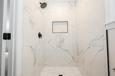
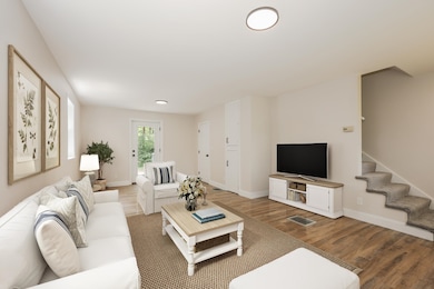
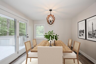
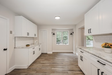
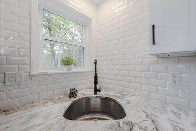
Welcome to this beautifully remodeled Cape-style home nestled on a serene 1-acre lot in the heart of Epsom, New Hampshire. This stunning property perfectly blends modern convenience with rustic charm, making it an idyllic sanctuary for families and nature lovers alike. Step inside to discover an open and inviting floor plan bathed in natural light. The expansive living area flows seamlessly into a brand-new gourmet kitchen that will inspire your inner chef. Featuring elegant granite countertops, modern stainless appliances, and ample cabinetry, this culinary haven is perfect for hosting gatherings or enjoying quiet family meals. The home's striking remodel continues into the luxurious bathrooms, where contemporary fixtures meet stylish design choices—creating private spaces that offer comfort and relaxation at every turn. Retreat upstairs to find generously sized bedrooms filled with character and warmth; each one offers a peaceful escape as well as scenic views of your sprawling land. Outside, you'll appreciate the detached two-car garage complete with a versatile loft space—ideal for storage or workshop use. Surrounded by lush greenery and picturesque rural landscapes you can enjoy from the back deck. Schedule a showing today!
| Date | Type | Sale Price | Title Company |
|---|---|---|---|
| Warranty Deed | $414,933 | -- | |
| Foreclosure Deed | $225,000 | None Available | |
| Foreclosure Deed | $225,000 | None Available | |
| Deed | $123,000 | -- | |
| Deed | $123,000 | -- | |
| Warranty Deed | $86,900 | -- | |
| Warranty Deed | $86,900 | -- |
| Date | Status | Loan Amount | Loan Type |
|---|---|---|---|
| Open | $248,940 | New Conventional | |
| Previous Owner | $120,280 | Purchase Money Mortgage | |
| Previous Owner | $84,961 | Purchase Money Mortgage |
| Date | Event | Price | List to Sale | Price per Sq Ft |
|---|---|---|---|---|
| 02/06/2026 02/06/26 | Sold | $414,900 | -2.4% | $268 / Sq Ft |
| 11/20/2025 11/20/25 | Price Changed | $424,900 | -2.3% | $274 / Sq Ft |
| 11/14/2025 11/14/25 | Price Changed | $434,700 | 0.0% | $281 / Sq Ft |
| 11/11/2025 11/11/25 | Price Changed | $434,800 | 0.0% | $281 / Sq Ft |
| 10/30/2025 10/30/25 | Price Changed | $434,900 | -1.0% | $281 / Sq Ft |
| 10/22/2025 10/22/25 | Price Changed | $439,500 | 0.0% | $284 / Sq Ft |
| 10/16/2025 10/16/25 | Price Changed | $439,600 | 0.0% | $284 / Sq Ft |
| 10/10/2025 10/10/25 | Price Changed | $439,700 | 0.0% | $284 / Sq Ft |
| 10/07/2025 10/07/25 | Price Changed | $439,800 | 0.0% | $284 / Sq Ft |
| 09/26/2025 09/26/25 | Price Changed | $439,900 | -2.2% | $284 / Sq Ft |
| 09/11/2025 09/11/25 | Price Changed | $449,800 | 0.0% | $291 / Sq Ft |
| 09/04/2025 09/04/25 | Price Changed | $449,900 | -2.2% | $291 / Sq Ft |
| 08/22/2025 08/22/25 | Price Changed | $459,900 | -2.1% | $297 / Sq Ft |
| 08/01/2025 08/01/25 | Price Changed | $469,700 | 0.0% | $303 / Sq Ft |
| 07/26/2025 07/26/25 | Price Changed | $469,800 | 0.0% | $303 / Sq Ft |
| 07/23/2025 07/23/25 | Price Changed | $469,900 | -1.1% | $304 / Sq Ft |
| 07/16/2025 07/16/25 | Price Changed | $474,900 | -1.0% | $307 / Sq Ft |
| 07/10/2025 07/10/25 | Price Changed | $479,800 | 0.0% | $310 / Sq Ft |
| 07/03/2025 07/03/25 | For Sale | $479,900 | -- | $310 / Sq Ft |
| Year | Tax Paid | Tax Assessment Tax Assessment Total Assessment is a certain percentage of the fair market value that is determined by local assessors to be the total taxable value of land and additions on the property. | Land | Improvement |
|---|---|---|---|---|
| 2024 | $6,215 | $233,300 | $82,100 | $151,200 |
| 2023 | $5,746 | $233,300 | $82,100 | $151,200 |
| 2022 | $5,562 | $233,300 | $82,100 | $151,200 |
| 2021 | $5,515 | $233,300 | $82,100 | $151,200 |
| 2020 | $0 | $233,300 | $82,100 | $151,200 |
| 2019 | $0 | $201,800 | $73,600 | $128,200 |
| 2018 | $39 | $201,800 | $73,600 | $128,200 |
| 2017 | $0 | $201,800 | $73,600 | $128,200 |
| 2016 | $0 | $201,800 | $73,600 | $128,200 |
| 2015 | $4,807 | $201,800 | $73,600 | $128,200 |
| 2014 | $4,105 | $184,400 | $65,500 | $118,900 |
| 2013 | $4,218 | $186,900 | $65,500 | $121,400 |
Seller's Agent in 2026
Michael Gallo
Gallo Realty Group
(603) 836-0151
3 in this area
114 Total Sales
E
Buyer's Agent in 2026
Elijah VanDenBerg
Realty One Group Next Level
(508) 614-0900
2 in this area
38 Total Sales
Source: PrimeMLS
MLS Number: 5049836
APN: EPSO-000009R-000000-000024
Disclaimer: Certain information contained herein is derived from information provided by parties other than Homes.com. All information provided is deemed reliable, but is not guaranteed to be accurate and should be independently verified.
![]() Copyright 2026 PrimeMLS, Inc. All rights reserved. This information is deemed reliable, but not guaranteed. The data relating to real estate displayed on this display comes in part from the IDX Program of PrimeMLS. The information being provided is for consumers’ personal, non-commercial use and may not be used for any purpose other than to identify prospective properties consumers may be interested in purchasing.
Copyright 2026 PrimeMLS, Inc. All rights reserved. This information is deemed reliable, but not guaranteed. The data relating to real estate displayed on this display comes in part from the IDX Program of PrimeMLS. The information being provided is for consumers’ personal, non-commercial use and may not be used for any purpose other than to identify prospective properties consumers may be interested in purchasing.
Ask me questions while you tour the home.