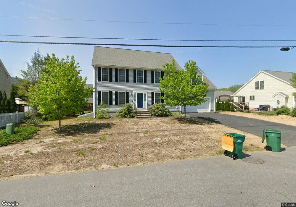
20 Norway Plains Rd Rochester, NH 03868
Estimated Value: $428,000 - $522,000
3
Beds
3
Baths
2,033
Sq Ft
$241/Sq Ft
Est. Value
About This Home
This home is located at 20 Norway Plains Rd, Rochester, NH 03868 and is currently estimated at $489,523, approximately $240 per square foot. 20 Norway Plains Rd is a home located in Strafford County with nearby schools including Chamberlain Street School, Rochester Middle School, and Spaulding High School.
Ownership History
Date
Name
Owned For
Owner Type
Purchase Details
Closed on
Jun 25, 2008
Sold by
Norway Plains Rt
Bought by
Duprey Matthew L and Hancock Ashley L
Current Estimated Value
Home Financials for this Owner
Home Financials are based on the most recent Mortgage that was taken out on this home.
Original Mortgage
$180,000
Interest Rate
6.07%
Mortgage Type
Purchase Money Mortgage
Create a Home Valuation Report for This Property
The Home Valuation Report is an in-depth analysis detailing your home's value as well as a comparison with similar homes in the area
Home Values in the Area
Average Home Value in this Area
Purchase History
| Date | Buyer | Sale Price | Title Company |
|---|---|---|---|
| Duprey Matthew L | $225,000 | -- |
Source: Public Records
Mortgage History
| Date | Status | Borrower | Loan Amount |
|---|---|---|---|
| Open | Duprey Matthew L | $173,225 | |
| Closed | Duprey Matthew L | $180,000 |
Source: Public Records
Tax History Compared to Growth
Tax History
| Year | Tax Paid | Tax Assessment Tax Assessment Total Assessment is a certain percentage of the fair market value that is determined by local assessors to be the total taxable value of land and additions on the property. | Land | Improvement |
|---|---|---|---|---|
| 2024 | $6,469 | $435,600 | $77,400 | $358,200 |
| 2023 | $6,615 | $257,000 | $37,600 | $219,400 |
| 2022 | $6,497 | $257,000 | $37,600 | $219,400 |
| 2021 | $6,335 | $257,000 | $37,600 | $219,400 |
| 2020 | $6,327 | $257,100 | $37,600 | $219,500 |
| 2019 | $6,402 | $257,100 | $37,600 | $219,500 |
| 2018 | $6,019 | $218,700 | $39,300 | $179,400 |
| 2017 | $5,758 | $218,700 | $39,300 | $179,400 |
| 2016 | $6,850 | $242,400 | $39,300 | $203,100 |
| 2015 | $6,824 | $242,400 | $39,300 | $203,100 |
| 2014 | $6,659 | $242,400 | $39,300 | $203,100 |
| 2013 | $5,707 | $216,500 | $52,400 | $164,100 |
| 2012 | $5,560 | $216,500 | $52,400 | $164,100 |
Source: Public Records
Map
Nearby Homes
- 79 Millers Farm Dr
- 8 Perimeter Dr
- 157 Wakefield St
- 180 Chestnut Hill Rd
- 2 Freedom Dr
- 3 Freedom Dr Unit 17
- 22 Cherokee Way
- 5 Monadnock Dr
- 30 Cherokee Way
- 10 Lady Slipper Ct
- 80 Woodland Green
- 41 Kinsale Dr
- 49 Shiloh Dr
- 74 Seneca St
- 105 Wakefield St
- 22 Trade Wind Ln
- 13 Crosswind Ln
- 2 Cape Coral Way Unit A
- 2 Cape Coral Way Unit B
- 16 Nashoba Dr
- 7 Lantern Ln
- 22 Norway Plains Rd
- 1 Rangeway Dr
- 3 Lantern Ln
- 9 Lantern Ln
- 5 Rangeway Dr
- 11 Lantern Ln
- 4 Lantern Lane (Lot 12-64)
- 12 Norway Plains Rd
- 17 Norway Plains Rd
- 2 Millers Farm Dr
- 13 Lantern Ln
- 1 Norway Plains Rd
- 6 Lantern Ln
- 8 Lantern Ln
- 4 Lantern Ln
- 4 Rangeway Dr
- 12 Lantern Ln
- 6 Rangeway Dr
- 00 Rangeway Drive Lot 1