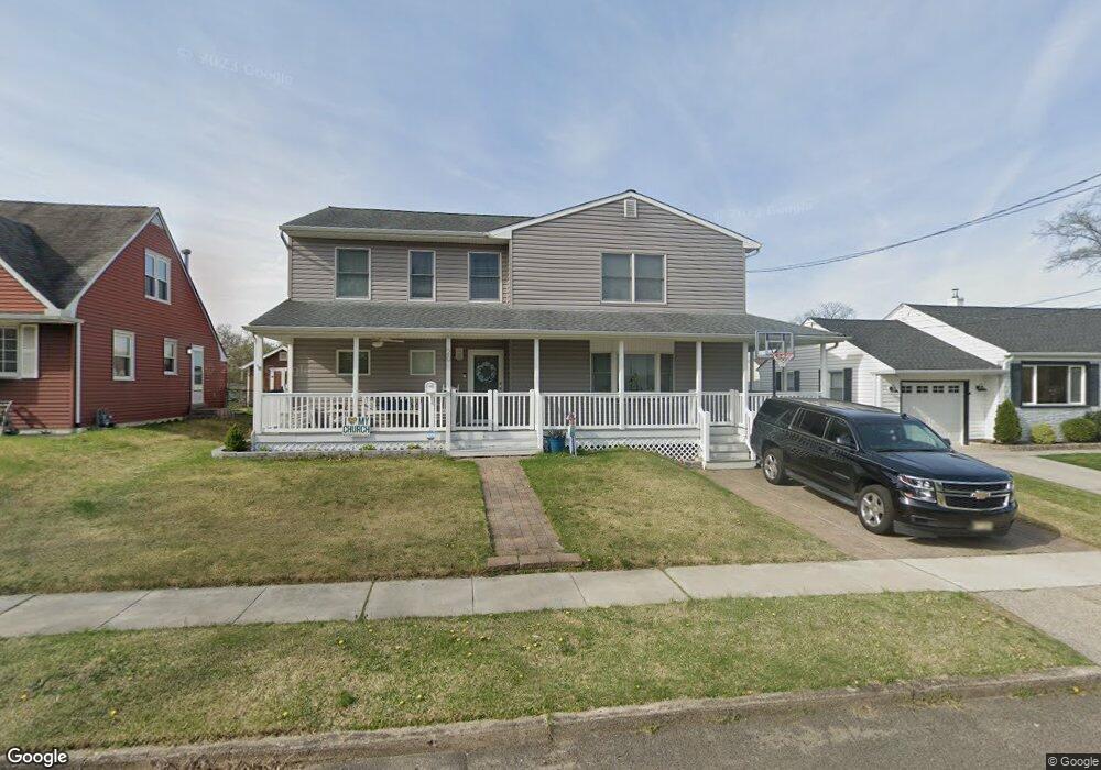
20 Overbrook Ave Maple Shade, NJ 08052
Estimated Value: $417,344 - $526,000
Studio
--
Bath
2,884
Sq Ft
$166/Sq Ft
Est. Value
About This Home
This home is located at 20 Overbrook Ave, Maple Shade, NJ 08052 and is currently estimated at $477,586, approximately $165 per square foot. 20 Overbrook Ave is a home located in Burlington County with nearby schools including Ralph J Steinhauer Elementary School, Maude M. Wilkins Elementary School, and Howard R Yocum School.
Ownership History
Date
Name
Owned For
Owner Type
Purchase Details
Closed on
Apr 14, 2004
Sold by
Hasson Sean P and Hasson Patricia A
Bought by
Schweizer Paul A
Current Estimated Value
Home Financials for this Owner
Home Financials are based on the most recent Mortgage that was taken out on this home.
Original Mortgage
$147,000
Outstanding Balance
$67,919
Interest Rate
5.4%
Mortgage Type
Purchase Money Mortgage
Estimated Equity
$409,667
Purchase Details
Closed on
Aug 26, 1999
Sold by
Stanton John J and Stanton Barbara A
Bought by
Hasson Sean P and Lafferty Patricia A
Purchase Details
Closed on
May 31, 1996
Sold by
Lare John J
Bought by
Stanton John J and Bimmer Barbara A
Purchase Details
Closed on
Mar 30, 1995
Sold by
Lare Catherine E
Bought by
Lare John J
Create a Home Valuation Report for This Property
The Home Valuation Report is an in-depth analysis detailing your home's value as well as a comparison with similar homes in the area
Home Values in the Area
Average Home Value in this Area
Purchase History
| Date | Buyer | Sale Price | Title Company |
|---|---|---|---|
| Schweizer Paul A | $152,000 | Integrity Title Agency Inc | |
| Hasson Sean P | $91,000 | Surety Title Corporation | |
| Stanton John J | $89,500 | Independence Abstract & Titl | |
| Lare John J | -- | -- |
Source: Public Records
Mortgage History
| Date | Status | Borrower | Loan Amount |
|---|---|---|---|
| Open | Schweizer Paul A | $147,000 |
Source: Public Records
Tax History
| Year | Tax Paid | Tax Assessment Tax Assessment Total Assessment is a certain percentage of the fair market value that is determined by local assessors to be the total taxable value of land and additions on the property. | Land | Improvement |
|---|---|---|---|---|
| 2025 | $9,961 | $262,400 | $48,900 | $213,500 |
| 2024 | $9,672 | $262,400 | $48,900 | $213,500 |
| 2023 | $9,672 | $262,400 | $48,900 | $213,500 |
| 2022 | $9,523 | $262,400 | $48,900 | $213,500 |
| 2021 | $9,431 | $262,400 | $48,900 | $213,500 |
| 2020 | $9,457 | $262,400 | $48,900 | $213,500 |
| 2019 | $9,111 | $262,400 | $48,900 | $213,500 |
| 2018 | $8,953 | $262,400 | $48,900 | $213,500 |
| 2017 | $5,894 | $174,800 | $48,900 | $125,900 |
| 2016 | $5,807 | $174,800 | $48,900 | $125,900 |
| 2015 | $5,681 | $134,200 | $48,900 | $85,300 |
| 2014 | $4,229 | $134,200 | $48,900 | $85,300 |
Source: Public Records
Map
Nearby Homes
- 12 Overbrook Ave
- 2 Wyndale Ave
- 9 Woodbine Ave
- 5 Paul Rd
- 11 Rose Ave
- 47 S Lippincott Ave
- 8539 Bryn Mawr Ave
- 22 Theodore Ave
- 66 W Center Ave
- 8323 Maple Ave
- 400 N Forklanding Rd
- 63 Mecray Ln
- 331 Collins Ln
- 106 Avignon Way
- 207 E Park Ave
- 27 Indian Queen Ln
- 411 A3 Stiles Ave Unit A-3
- 411 C12 Stiles Ave Unit C-12
- 411 A2 Stiles Ave Unit A-2
- 452 Elm Ave
- 18 Overbrook Ave
- 22 Overbrook Ave
- 17 Wyndale Ave
- 15 Wyndale Ave
- 16 Overbrook Ave
- 24 Overbrook Ave
- 19 Wyndale Ave
- 13 Wyndale Ave
- 21 Overbrook Ave
- 21 Wyndale Ave
- 19 Overbrook Ave
- 23 Overbrook Ave
- 14 Overbrook Ave
- 26 Overbrook Ave
- 17 Overbrook Ave
- 11 Wyndale Ave
- 25 Overbrook Ave
- 23 Wyndale Ave
- 28 Overbrook Ave
- 15 Overbrook Ave
Your Personal Tour Guide
Ask me questions while you tour the home.