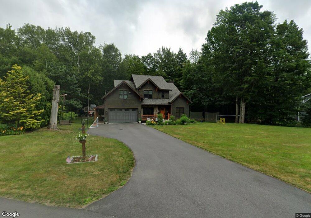
20 Pollard Pines Dr Lincoln, NH 03251
Estimated Value: $1,036,885 - $1,314,000
4
Beds
4
Baths
2,562
Sq Ft
$448/Sq Ft
Est. Value
About This Home
This home is located at 20 Pollard Pines Dr, Lincoln, NH 03251 and is currently estimated at $1,146,971, approximately $447 per square foot. 20 Pollard Pines Dr is a home located in Grafton County with nearby schools including Lin-Wood Public Elementary School.
Ownership History
Date
Name
Owned For
Owner Type
Purchase Details
Closed on
Dec 11, 2017
Sold by
Dufort James F and Dufort Andrea M
Bought by
Scambio Jason W and Scambio Katie W
Current Estimated Value
Home Financials for this Owner
Home Financials are based on the most recent Mortgage that was taken out on this home.
Original Mortgage
$584,100
Outstanding Balance
$496,409
Interest Rate
3.94%
Mortgage Type
Purchase Money Mortgage
Estimated Equity
$650,562
Purchase Details
Closed on
Dec 22, 2014
Sold by
Drouin Brenton W
Bought by
Dufort James R and Dufort Andrea M
Purchase Details
Closed on
Jun 5, 2007
Sold by
Pollard Pines Llc
Bought by
Drouin Brenton W and Drouin Katherine D
Home Financials for this Owner
Home Financials are based on the most recent Mortgage that was taken out on this home.
Original Mortgage
$392,000
Interest Rate
6.24%
Create a Home Valuation Report for This Property
The Home Valuation Report is an in-depth analysis detailing your home's value as well as a comparison with similar homes in the area
Home Values in the Area
Average Home Value in this Area
Purchase History
| Date | Buyer | Sale Price | Title Company |
|---|---|---|---|
| Scambio Jason W | $649,000 | -- | |
| Dufort James R | $585,000 | -- | |
| Drouin Brenton W | $137,700 | -- |
Source: Public Records
Mortgage History
| Date | Status | Borrower | Loan Amount |
|---|---|---|---|
| Open | Drouin Brenton W | $584,100 | |
| Previous Owner | Drouin Brenton W | $100,000 | |
| Previous Owner | Drouin Brenton W | $392,000 |
Source: Public Records
Tax History Compared to Growth
Tax History
| Year | Tax Paid | Tax Assessment Tax Assessment Total Assessment is a certain percentage of the fair market value that is determined by local assessors to be the total taxable value of land and additions on the property. | Land | Improvement |
|---|---|---|---|---|
| 2024 | $9,187 | $786,600 | $294,300 | $492,300 |
| 2023 | $9,187 | $786,600 | $294,300 | $492,300 |
| 2022 | $8,299 | $786,600 | $294,300 | $492,300 |
| 2021 | $8,291 | $786,600 | $294,300 | $492,300 |
| 2018 | $8,237 | $581,700 | $138,600 | $443,100 |
| 2016 | $7,673 | $581,700 | $138,600 | $443,100 |
| 2015 | $5,519 | $400,500 | $108,700 | $291,800 |
| 2014 | $5,527 | $400,500 | $108,700 | $291,800 |
| 2009 | $3,284 | $360,460 | $100,270 | $260,190 |
Source: Public Records
Map
Nearby Homes
- 42 Forest Dr
- 130 Woodland Loop
- 164 Pollard Rd
- 8 Louis Ln
- 51 Pollard Rd Unit 1
- 227 Main St Unit 231
- 227 Main St Unit 305
- 227 Main St Unit 106
- 227 Main St Unit 235
- 227 Main St Unit 224
- 13 Woodsview Ln Unit 2
- 18 Woodsview Ln Unit 2
- 13 Maple St
- 158 Pollard Rd
- 16 Twin Tip Terrace Unit 2
- 20 Twin Tip Terrace Unit 10
- 20 Twin Tip Terrace Unit 5
- 20 Twin Tip Terrace Unit 2
- 4 Twin Tip Terrace Unit 4
- 10 Bunker Ln Unit 114
- 0 Pollard Pines Dr Unit 2725415
- 0 Pollard Pines Dr Unit 2723553
- 0 Pollard Pines Dr Unit 2723589
- 0 Pollard Pines Dr Unit 2723573
- 0 Pollard Pines Dr Unit 117-043000-00
- 0 Pollard Pines Dr
- 5 Pollard Pines Dr
- 7 Pollard Pines Dr
- 13 Pollard Pines Dr
- 21 Pollard Pines Dr
- 10 Pollard Pines Dr
- 56 Forest Dr
- 54 Forest Dr
- 26 Conn Dr
- 78 Pollard Rd
- 45 Forest Dr
- 216-B Lodge Rd Unit 216-B
- 201 Lodge Rd Unit 201B
- 201 Lodge Rd
- 104 Pollard Rd