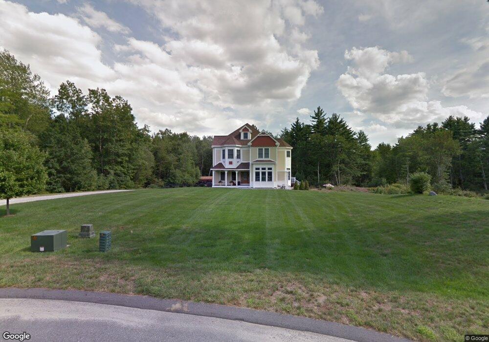
20 Powers Cir Merrimack, NH 03054
Estimated Value: $1,031,000 - $1,272,000
4
Beds
5
Baths
4,082
Sq Ft
$280/Sq Ft
Est. Value
About This Home
This home is located at 20 Powers Cir, Merrimack, NH 03054 and is currently estimated at $1,144,428, approximately $280 per square foot. 20 Powers Cir is a home located in Hillsborough County with nearby schools including Reeds Ferry School, Merrimack Middle School, and James Mastricola Upper Elementary School.
Ownership History
Date
Name
Owned For
Owner Type
Purchase Details
Closed on
Oct 22, 2019
Sold by
Johanna H Lindsey Ret
Bought by
Johanna H Lindsey Ret
Current Estimated Value
Purchase Details
Closed on
Aug 4, 2011
Sold by
Dwyer Daniel and Dwyer Julie
Bought by
Lindsey Johanna H
Create a Home Valuation Report for This Property
The Home Valuation Report is an in-depth analysis detailing your home's value as well as a comparison with similar homes in the area
Home Values in the Area
Average Home Value in this Area
Purchase History
| Date | Buyer | Sale Price | Title Company |
|---|---|---|---|
| Johanna H Lindsey Ret | -- | -- | |
| Lindsey Johanna H | $570,000 | -- |
Source: Public Records
Mortgage History
| Date | Status | Borrower | Loan Amount |
|---|---|---|---|
| Previous Owner | Lindsey Johanna H | $384,000 | |
| Previous Owner | Lindsey Johanna H | $50,000 | |
| Previous Owner | Lindsey Johanna H | $379,800 |
Source: Public Records
Tax History Compared to Growth
Tax History
| Year | Tax Paid | Tax Assessment Tax Assessment Total Assessment is a certain percentage of the fair market value that is determined by local assessors to be the total taxable value of land and additions on the property. | Land | Improvement |
|---|---|---|---|---|
| 2024 | $17,628 | $852,000 | $312,100 | $539,900 |
| 2023 | $16,571 | $852,000 | $312,100 | $539,900 |
| 2022 | $14,808 | $852,000 | $312,100 | $539,900 |
| 2021 | $14,629 | $852,000 | $312,100 | $539,900 |
| 2020 | $15,124 | $628,600 | $189,300 | $439,300 |
| 2019 | $15,168 | $628,600 | $189,300 | $439,300 |
| 2018 | $15,162 | $628,600 | $189,300 | $439,300 |
| 2017 | $14,690 | $628,600 | $189,300 | $439,300 |
| 2016 | $13,669 | $599,800 | $189,300 | $410,500 |
| 2015 | $14,263 | $577,000 | $177,000 | $400,000 |
| 2014 | $13,900 | $577,000 | $177,000 | $400,000 |
| 2013 | $13,796 | $577,000 | $177,000 | $400,000 |
Source: Public Records
Map
Nearby Homes
- 79 Woodward Rd
- 29 Brieann Dr
- 44 McQuade Brook Rd
- 5 Carter Rd
- 4 Miriam Rd
- 2 Baxter Ln
- 20 Jakes Ln
- 10 Winterberry Dr
- 52 Hardy Rd
- 40 Seton Dr
- 4 Milford St
- 10 Colman Path
- 14 Silver Doe Ln
- 16 Summit Rd
- 56 Greenfield Pkwy
- 276 N Amherst Rd
- 258 N Amherst Rd Unit 34
- 301 N Amherst Rd
- 40 Captain Bannon Cir
- 150 Wallace Rd