
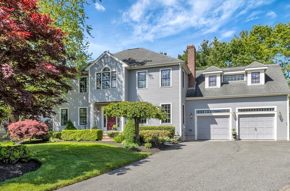
20 Quarry Ln North Easton, MA 02356
Estimated payment $7,372/month
Total Views
9,921
4
Beds
4
Baths
4,372
Sq Ft
$263
Price per Sq Ft
Highlights
- Golf Course Community
- Medical Services
- Colonial Architecture
- Easton Middle School Rated A-
- Open Floorplan
- Landscaped Professionally
About This Home
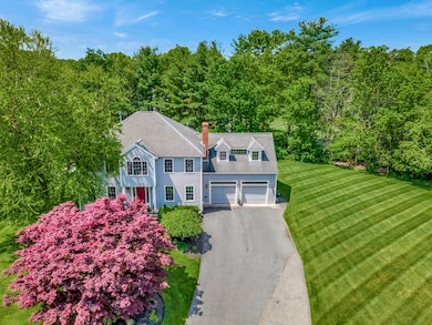
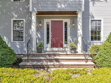
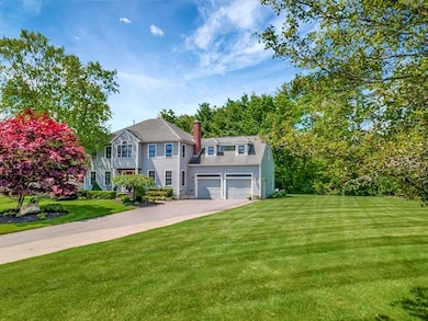
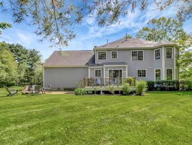
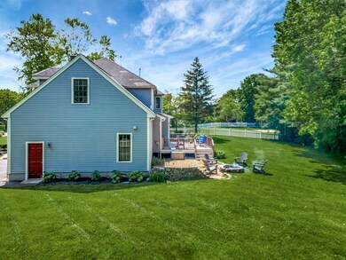
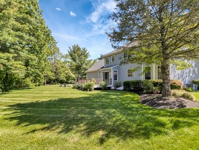
At the end of a cul-de-sac in desirable Rockland Bay Estates near Borderland State Park, the Town Forest, and the school complex sits this beautiful home. The outdoor space is gorgeous! Mature, manicured landscaping and a yard that murmurs to you to sit back and relax. Come inside to the large open floor plan living space ideal for entertaining with plenty of room for family and friends. The wonderful center island kitchen flows to the light and bright family room with a charming double arched fireplace for cozy nights. The spacious dining room opens to the living room and calls for dinner parties! Upstairs the large primary suite with bonus room can be used as a workout or reading room and has 2 walk in closets. Convenient 2nd floor laundry and office. Use the huge finished area in the basement complete with half bath for a rec room or man cave. Tons of storage and a cedar closet! So much space to spread out and enjoy a beautiful life. Bonus: 1 year home warranty included for buyers.
Home Details
Home Type
- Single Family
Est. Annual Taxes
- $12,019
Year Built
- Built in 2004
Lot Details
- 0.47 Acre Lot
- Landscaped Professionally
- Level Lot
- Sprinkler System
Parking
- 2 Car Attached Garage
- Parking Storage or Cabinetry
- Garage Door Opener
- Driveway
- Open Parking
- Off-Street Parking
Home Design
- Colonial Architecture
- Frame Construction
- Shingle Roof
- Concrete Perimeter Foundation
Interior Spaces
- Open Floorplan
- Ceiling Fan
- Recessed Lighting
- Bay Window
- Entrance Foyer
- Family Room with Fireplace
- Dining Area
- Home Office
- Bonus Room
- Game Room
- Storage
Kitchen
- Range<<rangeHoodToken>>
- <<microwave>>
- Dishwasher
- Kitchen Island
- Solid Surface Countertops
Flooring
- Wood
- Wall to Wall Carpet
- Laminate
- Ceramic Tile
Bedrooms and Bathrooms
- 4 Bedrooms
- Primary bedroom located on second floor
- Cedar Closet
- Linen Closet
- Walk-In Closet
- Dual Vanity Sinks in Primary Bathroom
- Soaking Tub
- <<tubWithShowerToken>>
- Separate Shower
- Linen Closet In Bathroom
Laundry
- Laundry on upper level
- Dryer
- Washer
Finished Basement
- Basement Fills Entire Space Under The House
- Interior and Exterior Basement Entry
- Sump Pump
Outdoor Features
- Bulkhead
- Deck
- Patio
Location
- Property is near schools
Schools
- Blanche AMES Elementary School
- Easton Middle School
- Oliver AMES High School
Utilities
- Forced Air Heating and Cooling System
- 2 Cooling Zones
- 3 Heating Zones
- Heating System Uses Natural Gas
- Radiant Heating System
- Gas Water Heater
- Private Sewer
Listing and Financial Details
- Home warranty included in the sale of the property
- Assessor Parcel Number M:0005R B:0357 L:0000,2802385
Community Details
Overview
- No Home Owners Association
- Rockland Bay Estates Subdivision
Amenities
- Medical Services
- Shops
Recreation
- Golf Course Community
- Tennis Courts
- Community Pool
- Park
- Jogging Path
Map
Create a Home Valuation Report for This Property
The Home Valuation Report is an in-depth analysis detailing your home's value as well as a comparison with similar homes in the area
Home Values in the Area
Average Home Value in this Area
Tax History
| Year | Tax Paid | Tax Assessment Tax Assessment Total Assessment is a certain percentage of the fair market value that is determined by local assessors to be the total taxable value of land and additions on the property. | Land | Improvement |
|---|---|---|---|---|
| 2025 | $12,019 | $963,100 | $393,500 | $569,600 |
| 2024 | $11,586 | $867,900 | $299,500 | $568,400 |
| 2023 | $11,021 | $755,400 | $291,500 | $463,900 |
| 2022 | $10,916 | $709,300 | $262,600 | $446,700 |
| 2021 | $10,796 | $697,400 | $250,700 | $446,700 |
| 2020 | $10,454 | $679,700 | $246,000 | $433,700 |
| 2019 | $10,264 | $643,100 | $221,600 | $421,500 |
| 2018 | $10,006 | $617,300 | $221,600 | $395,700 |
| 2017 | $9,578 | $590,500 | $221,600 | $368,900 |
| 2016 | $9,215 | $569,200 | $218,100 | $351,100 |
| 2015 | $9,627 | $573,700 | $222,600 | $351,100 |
| 2014 | $8,956 | $537,900 | $191,300 | $346,600 |
Source: Public Records
Property History
| Date | Event | Price | Change | Sq Ft Price |
|---|---|---|---|---|
| 06/04/2025 06/04/25 | For Sale | $1,150,000 | -- | $263 / Sq Ft |
Source: MLS Property Information Network (MLS PIN)
Purchase History
| Date | Type | Sale Price | Title Company |
|---|---|---|---|
| Deed | $670,000 | -- | |
| Deed | $670,000 | -- | |
| Deed | $220,000 | -- | |
| Deed | $220,000 | -- |
Source: Public Records
Mortgage History
| Date | Status | Loan Amount | Loan Type |
|---|---|---|---|
| Open | $277,000 | Stand Alone Refi Refinance Of Original Loan | |
| Closed | $280,000 | Unknown | |
| Closed | $300,000 | No Value Available | |
| Closed | $100,000 | No Value Available | |
| Closed | $153,000 | Purchase Money Mortgage |
Source: Public Records
Similar Homes in the area
Source: MLS Property Information Network (MLS PIN)
MLS Number: 73385896
APN: EAST-000005R-000357
Disclaimer: Certain information contained herein is derived from information provided by parties other than Homes.com. All information provided is deemed reliable, but is not guaranteed to be accurate and should be independently verified.
![]() The property listing data and information, or the Images, set forth herein were provided to MLS Property Information Network, Inc. from third party sources, including sellers, lessors and public records, and were compiled by MLS Property Information Network, Inc. The property listing data and information, and the Images, are for the personal, non-commercial use of consumers having a good faith interest in purchasing or leasing listed properties of the type displayed to them and may not be used for any purpose other than to identify prospective properties which such consumers may have a good faith interest in purchasing or leasing. MLS Property Information Network, Inc. and its subscribers disclaim any and all representations and warranties as to the accuracy of the property listing data and information, or as to the accuracy of any of the Images, set forth herein.
The property listing data and information, or the Images, set forth herein were provided to MLS Property Information Network, Inc. from third party sources, including sellers, lessors and public records, and were compiled by MLS Property Information Network, Inc. The property listing data and information, and the Images, are for the personal, non-commercial use of consumers having a good faith interest in purchasing or leasing listed properties of the type displayed to them and may not be used for any purpose other than to identify prospective properties which such consumers may have a good faith interest in purchasing or leasing. MLS Property Information Network, Inc. and its subscribers disclaim any and all representations and warranties as to the accuracy of the property listing data and information, or as to the accuracy of any of the Images, set forth herein.
Nearby Homes
- 12 Sandy Pond Ln
- 12 Waterbury Ln
- 40 Rockland St
- 133 Allen Rd
- 1 Daniel Dr
- 22 Douglas Dr
- 15 Randall Farm Dr
- 30 Bay Rd
- 32 Heritage Dr
- 15 Victory Ln
- 89 Massapoag Ave
- 45 Randall St
- 23 Rufus Jones Ln
- 15 Aspen Hollow Dr
- 22 Randall St
- 45 Columbus Ave
- 30 Owl Ridge Rd
- 41 Summer St
- 120 Sheridan St
- 21 Galahad Way
- 8 Lincoln St Unit 215
- 50 Main St
- 50 Oliver St Unit B
- 11 Elderberry Dr
- 60 Robert Dr
- 8 Island Ct
- 11 Roosevelt Cir
- 7 Roosevelt Cir
- 244 Washington St
- 7 Wadsworth Way Unit 1
- 16 Erick Rd Unit 16
- 23 Erick Rd Unit 25
- 617 Washington St Unit 2
- 12 Bonney Ln
- 10 Lawndale Rd Unit 1
- 9 Adam St
- 7 Nancy Rd Unit 9
- 10 Janet Rd
- 10 Janet Rd Unit 7
- 4 Link St