Estimated Value: $480,000 - $827,000
2
Beds
2
Baths
1,243
Sq Ft
$485/Sq Ft
Est. Value
About This Home
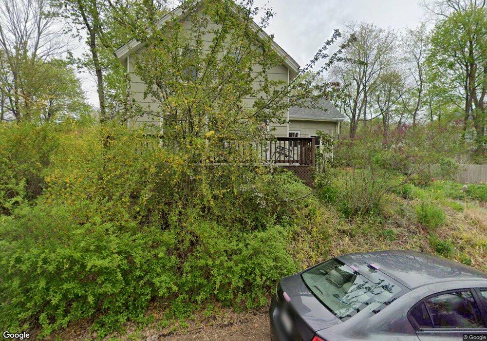
This home is located at 20 River St, Acton, MA 01720 and is currently estimated at $603,433, approximately $485 per square foot. 20 River St is a home located in Middlesex County with nearby schools including Acton-Boxborough Regional High School, Maynard Knowledge Beginnings, and The Imago School.
Ownership History
Date
Name
Owned For
Owner Type
Purchase Details
Closed on
Jul 18, 2023
Sold by
Mooney Gail F
Bought by
20 River Street Rt and Mooney
Current Estimated Value
Purchase Details
Closed on
Jul 15, 1992
Sold by
Beer Lawrence R and Beer Annette G
Bought by
Torzs Frederic M and Mooney Gail F
Create a Home Valuation Report for This Property
The Home Valuation Report is an in-depth analysis detailing your home's value as well as a comparison with similar homes in the area
Home Values in the Area
Average Home Value in this Area
Purchase History
| Date | Buyer | Sale Price | Title Company |
|---|---|---|---|
| 20 River Street Rt | -- | None Available | |
| Torzs Frederic M | $129,000 | -- | |
| Torzs Frederic M | $129,000 | -- |
Source: Public Records
Mortgage History
| Date | Status | Borrower | Loan Amount |
|---|---|---|---|
| Previous Owner | Torzs Frederic M | $250,000 | |
| Previous Owner | Torzs Frederic M | $180,000 |
Source: Public Records
Tax History
| Year | Tax Paid | Tax Assessment Tax Assessment Total Assessment is a certain percentage of the fair market value that is determined by local assessors to be the total taxable value of land and additions on the property. | Land | Improvement |
|---|---|---|---|---|
| 2025 | $8,038 | $468,700 | $267,800 | $200,900 |
| 2024 | $7,483 | $448,900 | $267,800 | $181,100 |
| 2023 | $7,456 | $424,600 | $243,500 | $181,100 |
| 2022 | $7,580 | $389,700 | $211,800 | $177,900 |
| 2021 | $6,931 | $342,600 | $196,000 | $146,600 |
| 2020 | $6,592 | $342,600 | $196,000 | $146,600 |
| 2019 | $6,216 | $320,900 | $196,000 | $124,900 |
| 2018 | $5,859 | $302,300 | $196,000 | $106,300 |
| 2017 | $5,762 | $302,300 | $196,000 | $106,300 |
| 2016 | $5,813 | $302,300 | $196,000 | $106,300 |
| 2015 | $5,685 | $298,400 | $196,000 | $102,400 |
| 2014 | $5,607 | $288,300 | $196,000 | $92,300 |
Source: Public Records
Map
Nearby Homes
- 40 High St
- 70 River St
- 25 Nylander Way
- 129 Main St Unit 129
- 131 Main St
- 30 Brewster Ln
- 1 Vanderbelt Rd
- 184 Main St Unit 3
- 7 Hillcrest Dr
- 7 Kelley Rd
- 246 Main St Unit 2
- 128 Parker St Unit 3B
- 63 Conant St
- 1 Drummer Rd Unit A5
- 31 Drummer Rd Unit 31
- 46 Taylor Rd
- 27 Forest Rd
- 18 Hayward Rd
- 36 Brown St
- 59 Lexington Dr
Your Personal Tour Guide
Ask me questions while you tour the home.