Estimated Value: $347,000 - $383,000
--
Bed
3
Baths
2,059
Sq Ft
$175/Sq Ft
Est. Value
About This Home
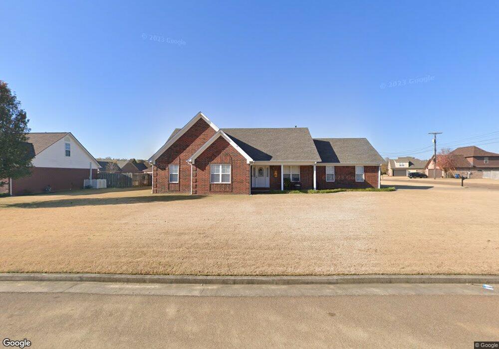
This home is located at 20 Sampson Cove, Atoka, TN 38004 and is currently estimated at $360,530, approximately $175 per square foot. 20 Sampson Cove is a home located in Tipton County with nearby schools including Atoka Elementary School, Munford Middle School, and Munford High School.
Ownership History
Date
Name
Owned For
Owner Type
Purchase Details
Closed on
Jun 5, 2013
Sold by
Jackson Vernon R
Bought by
Casey Larry D and Casey Lisa S
Current Estimated Value
Home Financials for this Owner
Home Financials are based on the most recent Mortgage that was taken out on this home.
Original Mortgage
$171,326
Outstanding Balance
$121,491
Interest Rate
3.42%
Mortgage Type
Commercial
Estimated Equity
$239,039
Purchase Details
Closed on
Nov 13, 2006
Sold by
Munford Development Compan
Bought by
Jackson Vernon R
Purchase Details
Closed on
Jul 5, 1999
Sold by
Munford Dev
Bought by
Marlyn Stringfelloe
Create a Home Valuation Report for This Property
The Home Valuation Report is an in-depth analysis detailing your home's value as well as a comparison with similar homes in the area
Home Values in the Area
Average Home Value in this Area
Purchase History
| Date | Buyer | Sale Price | Title Company |
|---|---|---|---|
| Casey Larry D | $177,900 | -- | |
| Jackson Vernon R | $40,000 | -- | |
| Marlyn Stringfelloe | $15,000 | -- |
Source: Public Records
Mortgage History
| Date | Status | Borrower | Loan Amount |
|---|---|---|---|
| Open | Casey Larry D | $171,326 |
Source: Public Records
Tax History Compared to Growth
Tax History
| Year | Tax Paid | Tax Assessment Tax Assessment Total Assessment is a certain percentage of the fair market value that is determined by local assessors to be the total taxable value of land and additions on the property. | Land | Improvement |
|---|---|---|---|---|
| 2024 | $1,795 | $79,550 | $15,025 | $64,525 |
| 2023 | $1,795 | $79,550 | $15,025 | $64,525 |
| 2022 | $1,716 | $55,900 | $11,050 | $44,850 |
| 2021 | $1,688 | $55,900 | $11,050 | $44,850 |
| 2020 | $1,687 | $55,900 | $11,050 | $44,850 |
| 2019 | $1,666 | $46,400 | $8,500 | $37,900 |
| 2018 | $1,657 | $46,175 | $8,500 | $37,675 |
| 2017 | $1,486 | $46,175 | $8,500 | $37,675 |
| 2016 | $1,486 | $46,175 | $8,500 | $37,675 |
| 2015 | $1,485 | $46,175 | $8,500 | $37,675 |
| 2014 | $1,372 | $46,163 | $0 | $0 |
Source: Public Records
Map
Nearby Homes
- 512 Kearns Cir
- 33 Hattie Ln
- 36 Hattie Ln
- 18 Fox Trot Ln
- 1240 Je Blaydes Pkwy
- 0 Meade Lake Rd Unit 10196514
- 107 Farmer Trail
- 156 Farmer Trail
- 343 Brittany Ln
- 91 Bethel Rd
- 102 Stroud Cir
- 376 Stroud Cir
- 02 Cobb Ave
- 03 Cobb Ave
- 01 Cobb Ave
- 0 Hwy 51 Hwy S Unit 10206150
- 665 Betty Boyd Ln
- 13724 51 S Highway Hwy
- 114 Walker Lake Rd
- 256 Azalea Dr