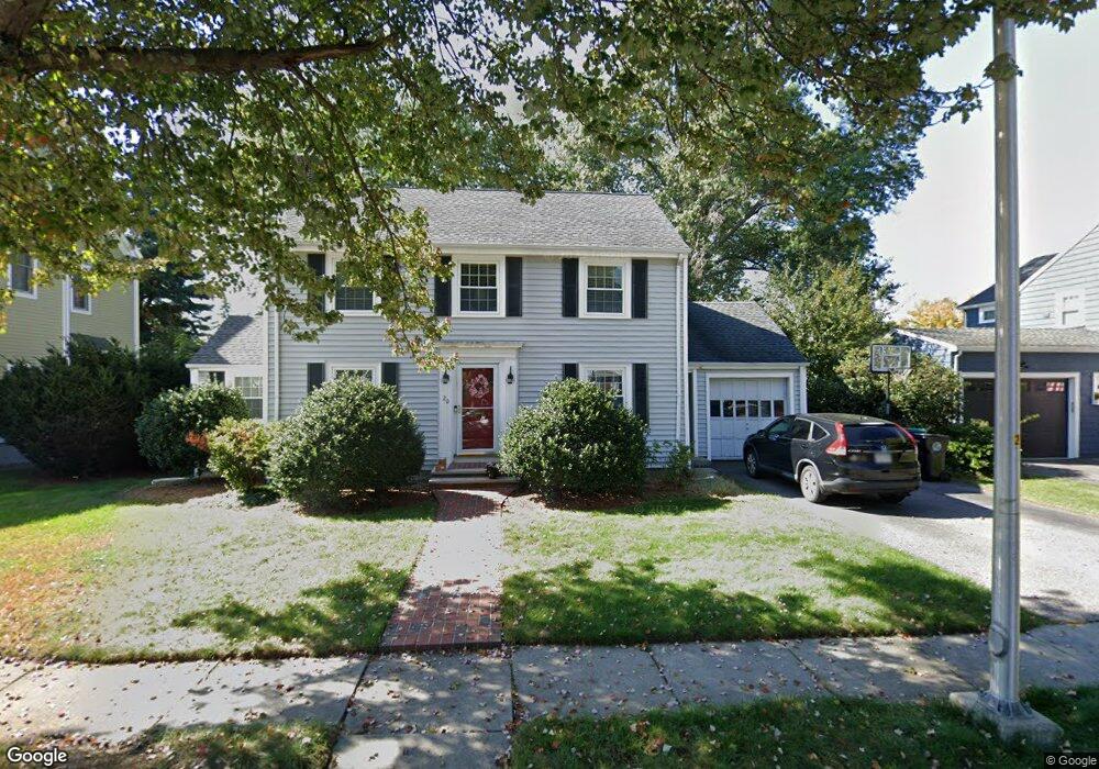
20 Sargent Rd Belmont, MA 02478
Cushing Square NeighborhoodEstimated Value: $1,436,491 - $1,543,000
3
Beds
3
Baths
1,725
Sq Ft
$857/Sq Ft
Est. Value
About This Home
This home is located at 20 Sargent Rd, Belmont, MA 02478 and is currently estimated at $1,478,123, approximately $856 per square foot. 20 Sargent Rd is a home located in Middlesex County with nearby schools including Mary Lee Burbank Elementary School, Winthrop L Chenery Middle School, and Belmont High School.
Ownership History
Date
Name
Owned For
Owner Type
Purchase Details
Closed on
Oct 17, 2022
Sold by
Chen Zhuoliang and Lin L
Bought by
Chen Family 2022 Ret
Current Estimated Value
Purchase Details
Closed on
Jun 16, 2004
Sold by
Martin Patricia A and Toreno Vincent J
Bought by
Lin Lin and Chen Zhuoliang
Home Financials for this Owner
Home Financials are based on the most recent Mortgage that was taken out on this home.
Original Mortgage
$568,800
Interest Rate
6.12%
Mortgage Type
Purchase Money Mortgage
Purchase Details
Closed on
Apr 2, 1993
Sold by
Brown Arlin and Brown Cynthia
Bought by
Martin Patricia A and Toreno Vincent J
Create a Home Valuation Report for This Property
The Home Valuation Report is an in-depth analysis detailing your home's value as well as a comparison with similar homes in the area
Home Values in the Area
Average Home Value in this Area
Purchase History
| Date | Buyer | Sale Price | Title Company |
|---|---|---|---|
| Chen Family 2022 Ret | -- | None Available | |
| Lin Lin | $711,000 | -- | |
| Martin Patricia A | $258,000 | -- |
Source: Public Records
Mortgage History
| Date | Status | Borrower | Loan Amount |
|---|---|---|---|
| Previous Owner | Martin Patricia A | $401,000 | |
| Previous Owner | Martin Patricia A | $417,000 | |
| Previous Owner | Lin Lin | $568,800 | |
| Previous Owner | Martin Patricia A | $170,000 |
Source: Public Records
Tax History
| Year | Tax Paid | Tax Assessment Tax Assessment Total Assessment is a certain percentage of the fair market value that is determined by local assessors to be the total taxable value of land and additions on the property. | Land | Improvement |
|---|---|---|---|---|
| 2025 | $15,103 | $1,326,000 | $792,000 | $534,000 |
| 2024 | $14,890 | $1,410,000 | $987,000 | $423,000 |
| 2023 | $13,983 | $1,244,000 | $861,000 | $383,000 |
| 2022 | $13,467 | $1,165,000 | $809,000 | $356,000 |
| 2021 | $13,156 | $1,140,000 | $843,000 | $297,000 |
| 2020 | $12,353 | $1,123,000 | $826,000 | $297,000 |
| 2019 | $10,433 | $894,000 | $614,000 | $280,000 |
| 2018 | $10,182 | $838,000 | $558,000 | $280,000 |
| 2017 | $10,050 | $792,000 | $512,000 | $280,000 |
| 2016 | $9,922 | $790,000 | $512,000 | $278,000 |
| 2015 | $9,082 | $704,000 | $426,000 | $278,000 |
Source: Public Records
Map
Nearby Homes
- 92 Shaw Rd
- 73 Foster Rd Unit 2
- 75 Foster Rd Unit 1
- 30 Unity Ave Unit 30
- 198 Belmont St Unit 1
- 147 Langdon Ave Unit 1
- 161 Cushing St
- 210 Belmont St Unit 13
- 210 Belmont St Unit 2
- 29 Commonwealth Rd Unit 1
- 773 Concord Ave Unit 103
- 60 Washington St
- 19 Keith St Unit 2
- 7-9 Clyde Rd
- 354 School St Unit 354
- 10 Clyde Rd Unit 10-1
- 10-12 Clyde Rd Unit 1
- 27-29 S Normandy Ave
- 11 Hillcrest Rd
- 17 Smith Place
Your Personal Tour Guide
Ask me questions while you tour the home.