M
Seller's Agent in 2025
Mei Howes
Greatland Real Estate LLC
(617) 308-3925
1 in this area
19 Total Sales

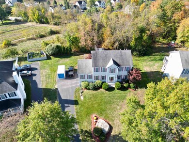

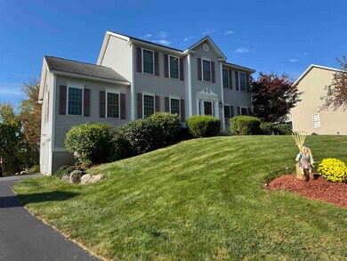
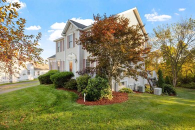
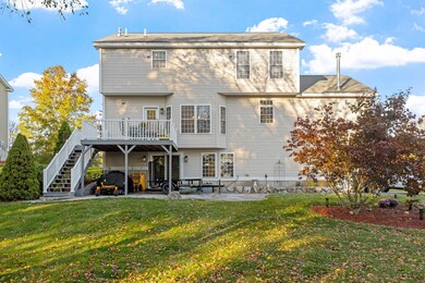
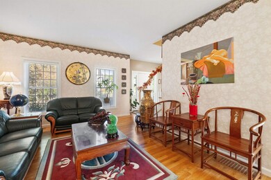
Welcome to this beautifully maintained 3 bedroom, 2.5 bath colonial located in one of Bedford’s most desirable neighborhoods. Featuring hardwood floors throughout both levels, this home offers a newly renovated kitchen with granite countertops, porcelain backsplash, and all new appliances. The living room showcases a cozy fireplace with custom built-in cabinetry on both sides, perfect for elegant gatherings or quiet evenings at home. The finished walkout basement provides flexible living space, including a home office, built-in study area, and media room. Step outside to a spacious patio ideal for entertaining, complemented by a freshly painted deck with new railings. Additional highlights include a smart irrigation system, standby generator, finished garage, and public water and sewer. This move-in ready home combines modern upgrades with timeless appeal, schedule your private showing today. Offer deadline: Tuesday October 28 at noon.
| Date | Type | Sale Price | Title Company |
|---|---|---|---|
| Deed | $352,000 | -- |
| Date | Status | Loan Amount | Loan Type |
|---|---|---|---|
| Open | $243,500 | Stand Alone Refi Refinance Of Original Loan | |
| Closed | $246,000 | Stand Alone Refi Refinance Of Original Loan | |
| Closed | $260,500 | Unknown | |
| Closed | $281,500 | Purchase Money Mortgage |
| Date | Event | Price | List to Sale | Price per Sq Ft |
|---|---|---|---|---|
| 11/24/2025 11/24/25 | Sold | $825,000 | -1.8% | $267 / Sq Ft |
| 10/28/2025 10/28/25 | Pending | -- | -- | -- |
| 10/18/2025 10/18/25 | Price Changed | $839,900 | -2.9% | $272 / Sq Ft |
| 10/09/2025 10/09/25 | For Sale | $865,000 | -- | $280 / Sq Ft |
| Year | Tax Paid | Tax Assessment Tax Assessment Total Assessment is a certain percentage of the fair market value that is determined by local assessors to be the total taxable value of land and additions on the property. | Land | Improvement |
|---|---|---|---|---|
| 2024 | $11,348 | $717,800 | $303,500 | $414,300 |
| 2023 | $10,623 | $717,800 | $303,500 | $414,300 |
| 2022 | $9,757 | $554,400 | $224,700 | $329,700 |
| 2021 | $9,502 | $554,400 | $224,700 | $329,700 |
| 2020 | $9,337 | $466,400 | $178,900 | $287,500 |
| 2019 | $8,838 | $466,400 | $178,900 | $287,500 |
| 2018 | $9,019 | $442,100 | $178,900 | $263,200 |
| 2017 | $8,360 | $442,100 | $178,900 | $263,200 |
| 2016 | $7,791 | $348,300 | $100,200 | $248,100 |
| 2015 | $7,927 | $348,300 | $100,200 | $248,100 |
| 2014 | $7,837 | $348,300 | $100,200 | $248,100 |
| 2013 | $7,722 | $348,300 | $100,200 | $248,100 |
M
Seller's Agent in 2025
Mei Howes
Greatland Real Estate LLC
(617) 308-3925
1 in this area
19 Total Sales
Source: PrimeMLS
MLS Number: 5065187
APN: BEDD-000039-000044-000019
Disclaimer: Certain information contained herein is derived from information provided by parties other than Homes.com. All information provided is deemed reliable, but is not guaranteed to be accurate and should be independently verified.
![]() Copyright 2025 PrimeMLS, Inc. All rights reserved. This information is deemed reliable, but not guaranteed. The data relating to real estate displayed on this display comes in part from the IDX Program of PrimeMLS. The information being provided is for consumers’ personal, non-commercial use and may not be used for any purpose other than to identify prospective properties consumers may be interested in purchasing.
Copyright 2025 PrimeMLS, Inc. All rights reserved. This information is deemed reliable, but not guaranteed. The data relating to real estate displayed on this display comes in part from the IDX Program of PrimeMLS. The information being provided is for consumers’ personal, non-commercial use and may not be used for any purpose other than to identify prospective properties consumers may be interested in purchasing.
