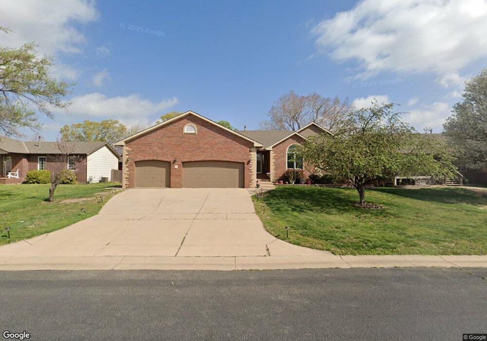
20 W Cedar Pointe Ct Goddard, KS 67052
Estimated Value: $287,000 - $311,560
3
Beds
3
Baths
1,526
Sq Ft
$196/Sq Ft
Est. Value
About This Home
This home is located at 20 W Cedar Pointe Ct, Goddard, KS 67052 and is currently estimated at $299,280, approximately $196 per square foot. 20 W Cedar Pointe Ct is a home located in Sedgwick County with nearby schools including Oak Street Elementary School, Discovery Intermediate School, and Dwight D. Eisenhower Middle School.
Ownership History
Date
Name
Owned For
Owner Type
Purchase Details
Closed on
Feb 16, 2000
Sold by
Berry Audrey K and Berry James C
Bought by
Wilkins John L and Wilkins Sheri R
Current Estimated Value
Home Financials for this Owner
Home Financials are based on the most recent Mortgage that was taken out on this home.
Original Mortgage
$125,910
Outstanding Balance
$41,622
Interest Rate
8.16%
Estimated Equity
$257,658
Create a Home Valuation Report for This Property
The Home Valuation Report is an in-depth analysis detailing your home's value as well as a comparison with similar homes in the area
Home Values in the Area
Average Home Value in this Area
Purchase History
| Date | Buyer | Sale Price | Title Company |
|---|---|---|---|
| Wilkins John L | -- | Security Abstract & Title Co |
Source: Public Records
Mortgage History
| Date | Status | Borrower | Loan Amount |
|---|---|---|---|
| Open | Wilkins John L | $125,910 |
Source: Public Records
Tax History Compared to Growth
Tax History
| Year | Tax Paid | Tax Assessment Tax Assessment Total Assessment is a certain percentage of the fair market value that is determined by local assessors to be the total taxable value of land and additions on the property. | Land | Improvement |
|---|---|---|---|---|
| 2025 | $4,080 | $35,087 | $8,890 | $26,197 |
| 2023 | $4,080 | $28,406 | $5,808 | $22,598 |
| 2022 | $3,159 | $24,012 | $5,474 | $18,538 |
| 2021 | $2,968 | $22,034 | $4,531 | $17,503 |
| 2020 | $2,918 | $21,390 | $4,531 | $16,859 |
| 2019 | $2,689 | $19,619 | $4,531 | $15,088 |
| 2018 | $2,797 | $20,091 | $2,726 | $17,365 |
| 2017 | $2,668 | $0 | $0 | $0 |
| 2016 | $2,621 | $0 | $0 | $0 |
| 2015 | $2,559 | $0 | $0 | $0 |
| 2014 | $3,393 | $0 | $0 | $0 |
Source: Public Records
Map
Nearby Homes
- 305 W Autumn Blaze Cir
- 5 N Hopper Dr
- 700 N Oak St
- 216 W Poplar St
- 1260 N Main St
- 102 E Poplar Ct
- 216 W Winterset Cir
- 130 Poplar Cir
- 138 Poplar Cir
- 141 Poplar Cir
- 118 Poplar Ct
- 400 Trails Head Cir
- 145 E Poplar Cir
- Lot 18 Block 3 Dry Creek Estates
- Lot 20 Block 3 Dry Creek Estates
- Lot 24 Block 3 Dry Creek Estates
- 877 N Cloverleaf St
- Lot Lot 13 Block 3 Dry Creek Estates
- Lot 17 Block 3 Dry Creek Estates
- 885 N Cloverleaf St
- 18 W Cedar Pointe Ct
- 22 W Cedar Pointe Ct
- 9 W Cedar Pointe Ct Unit 11
- 6 N Hopper Ct
- 8 N Hopper Ct
- 16 W Cedar Pointe Ct
- 11 W Cedar Pointe Ct
- 4 N Hopper Ct
- 24 W Cedar Pointe Ct
- 13 W Cedar Pointe Ct
- 5 W Cedar Pointe Ct
- 0 Cedar Pointe Ct
- 2 N Hopper Ct
- 3 Cedar Pointe Ct
- 1 W Cedar Pointe Ct
- 17 W Cedar Pointe Ct
- 14 W Cedar Pointe Ct
- 21 W Cedar Pointe Ct
- 929 N Oak St
- 12 N Hopper Ct