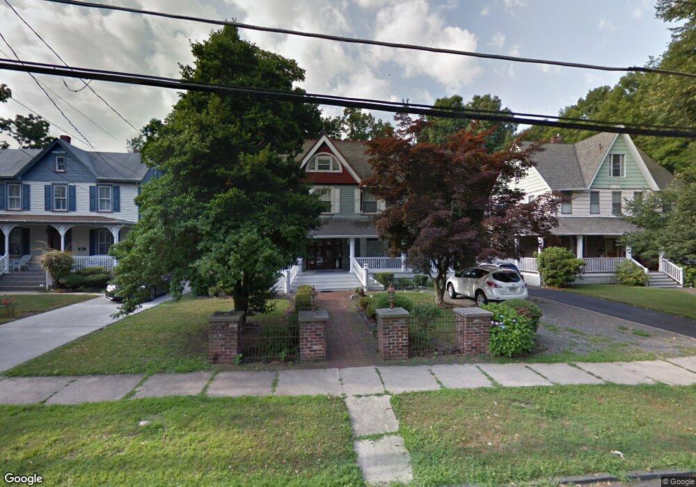
20 W Walnut Ave Merchantville, NJ 08109
Estimated Value: $415,000 - $521,191
--
Bed
--
Bath
2,861
Sq Ft
$164/Sq Ft
Est. Value
About This Home
This home is located at 20 W Walnut Ave, Merchantville, NJ 08109 and is currently estimated at $470,048, approximately $164 per square foot. 20 W Walnut Ave is a home located in Camden County with nearby schools including Merchantville Elementary School, St. Peter Elementary School, and St. Cecilia School.
Ownership History
Date
Name
Owned For
Owner Type
Purchase Details
Closed on
Oct 21, 2011
Sold by
Zia Joseph and Zia Ninamaria
Bought by
Zia Ninamaria
Current Estimated Value
Home Financials for this Owner
Home Financials are based on the most recent Mortgage that was taken out on this home.
Original Mortgage
$375,000
Interest Rate
4.08%
Mortgage Type
Reverse Mortgage Home Equity Conversion Mortgage
Create a Home Valuation Report for This Property
The Home Valuation Report is an in-depth analysis detailing your home's value as well as a comparison with similar homes in the area
Home Values in the Area
Average Home Value in this Area
Purchase History
| Date | Buyer | Sale Price | Title Company |
|---|---|---|---|
| Zia Ninamaria | -- | Platinum Abstract Company |
Source: Public Records
Mortgage History
| Date | Status | Borrower | Loan Amount |
|---|---|---|---|
| Closed | Zia Ninamaria | $375,000 |
Source: Public Records
Tax History Compared to Growth
Tax History
| Year | Tax Paid | Tax Assessment Tax Assessment Total Assessment is a certain percentage of the fair market value that is determined by local assessors to be the total taxable value of land and additions on the property. | Land | Improvement |
|---|---|---|---|---|
| 2025 | $14,889 | $279,400 | $67,300 | $212,100 |
| 2024 | $14,174 | $279,400 | $67,300 | $212,100 |
| 2023 | $14,174 | $279,400 | $67,300 | $212,100 |
| 2022 | $13,573 | $279,400 | $67,300 | $212,100 |
| 2021 | $12,633 | $279,400 | $67,300 | $212,100 |
| 2020 | $13,218 | $279,400 | $67,300 | $212,100 |
| 2019 | $12,973 | $279,400 | $67,300 | $212,100 |
| 2018 | $12,355 | $279,400 | $67,300 | $212,100 |
| 2017 | $11,833 | $279,400 | $67,300 | $212,100 |
| 2016 | $11,291 | $279,400 | $67,300 | $212,100 |
| 2015 | $10,473 | $279,400 | $67,300 | $212,100 |
| 2014 | $10,082 | $279,400 | $67,300 | $212,100 |
Source: Public Records
Map
Nearby Homes
- 116 N Centre St
- 41 Alexander Ave
- 2905 N Centre St
- 6160 Irving Ave
- 12 E Maple Ave Unit 18
- 5745 Cedar Ave
- 3300 Springfield Ave
- 137 S Centre St
- 5532 Whitman Terrace
- 6563 Park Ave
- 3204 Merchantville Ave
- 6134 Grant Ave
- 6167 Grant Ave
- 320 W Maple Ave
- 6555 Maple Ave
- 2254 Hollinshed Ave
- 10 Church Rd
- 412 W Maple Ave
- 3241 N 48th St
- 7028 Collins Ave
- 16 W Walnut Ave
- 24 W Walnut Ave
- 12 W Walnut Ave
- 8 W Walnut Ave
- 30 W Walnut Ave
- 32 W Walnut Ave
- 11 W Walnut Ave
- 2 W Walnut Ave
- 9 W Walnut Ave
- 19 W Walnut Ave
- 23 W Walnut Ave
- 5 W Walnut Ave
- 34 W Walnut Ave
- 24 N Centre St Unit 24B
- 24 N Centre St Unit 26
- 24 N Centre St Unit A
- 24 N Centre St
- 27 W Walnut Ave
- 22 N Centre St Unit 4
- 22 N Centre St Unit 5