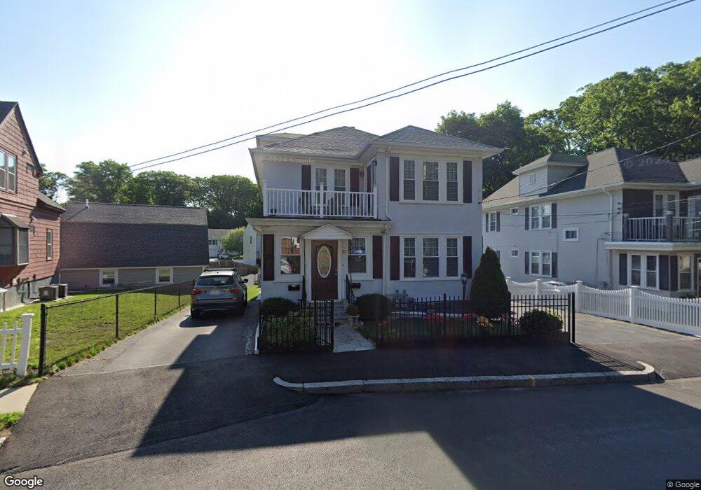
20 Wentworth St Worcester, MA 01603
Webster Square NeighborhoodEstimated Value: $454,661 - $544,000
4
Beds
2
Baths
2,256
Sq Ft
$229/Sq Ft
Est. Value
About This Home
This home is located at 20 Wentworth St, Worcester, MA 01603 and is currently estimated at $515,665, approximately $228 per square foot. 20 Wentworth St is a home located in Worcester County with nearby schools including Gates Lane, Jacob Hiatt Magnet School, and Chandler Magnet.
Ownership History
Date
Name
Owned For
Owner Type
Purchase Details
Closed on
Oct 30, 2002
Sold by
Hanson Shirley M
Bought by
Cace Thomas and Cace Valentina
Current Estimated Value
Home Financials for this Owner
Home Financials are based on the most recent Mortgage that was taken out on this home.
Original Mortgage
$155,000
Interest Rate
6.09%
Mortgage Type
Purchase Money Mortgage
Create a Home Valuation Report for This Property
The Home Valuation Report is an in-depth analysis detailing your home's value as well as a comparison with similar homes in the area
Home Values in the Area
Average Home Value in this Area
Purchase History
| Date | Buyer | Sale Price | Title Company |
|---|---|---|---|
| Cace Thomas | $200,000 | -- |
Source: Public Records
Mortgage History
| Date | Status | Borrower | Loan Amount |
|---|---|---|---|
| Open | Cace Thomas | $145,800 | |
| Closed | Cace Thomas | $155,000 |
Source: Public Records
Tax History Compared to Growth
Tax History
| Year | Tax Paid | Tax Assessment Tax Assessment Total Assessment is a certain percentage of the fair market value that is determined by local assessors to be the total taxable value of land and additions on the property. | Land | Improvement |
|---|---|---|---|---|
| 2025 | $6,154 | $466,600 | $85,400 | $381,200 |
| 2024 | $5,836 | $424,400 | $85,400 | $339,000 |
| 2023 | $5,459 | $380,700 | $74,300 | $306,400 |
| 2022 | $5,038 | $331,200 | $59,400 | $271,800 |
| 2021 | $4,594 | $282,200 | $47,500 | $234,700 |
| 2020 | $4,287 | $252,200 | $47,200 | $205,000 |
| 2019 | $4,289 | $238,300 | $41,200 | $197,100 |
| 2018 | $4,183 | $221,200 | $41,200 | $180,000 |
| 2017 | $3,975 | $206,800 | $41,200 | $165,600 |
| 2016 | $3,976 | $192,900 | $30,100 | $162,800 |
| 2015 | $3,872 | $192,900 | $30,100 | $162,800 |
| 2014 | $3,769 | $192,900 | $30,100 | $162,800 |
Source: Public Records
Map
Nearby Homes
- 28 Baker St
- 19 Monticello Dr
- 23 Lakewood St
- 40 Lakewood St
- 68 Crest Cir
- 45 Wildwood Ave
- 57 1st St
- 76 Parsons Hill Dr Unit A
- 16 Ward Farm Cir
- 47 4th St
- 45 Fourth St
- 45 Fourth St Unit Right
- 114 Henshaw St
- 114 Lovell St
- 170 Stafford St
- 1022 Main St
- 5 Stoneland Rd
- 12 Stoneland Rd
- 21 Healy Rd
- 19 Oliver St
- 18 Wentworth St
- 22 Wentworth St
- 16 Wentworth St
- 16 Wentworth St Unit 1
- 8 Roseville Ln
- 6 Roseville Ln
- 10 Roseville Ln
- 80 Gates Ln
- 80 Gates Ln Unit 1
- 4 Roseville Ln
- 21 Wentworth St
- 12 Wentworth St
- 76 Gates Ln
- 2 Roseville Ln
- 2 Catalpa Cir
- 0 Confidential Ave Unit 71301915
- lots 1-7 Antoine St
- 16 Calstad St Unit 2
- 74 Gates Ln
- 8 Wentworth St