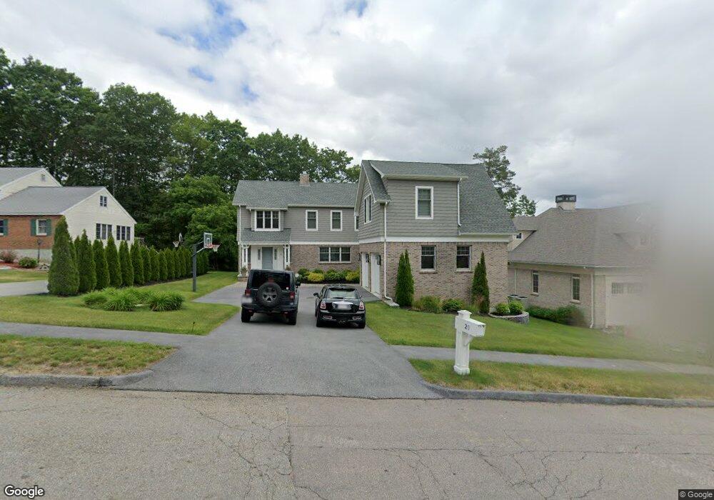
20 Whisper Dr Worcester, MA 01609
West Tatnuck NeighborhoodEstimated Value: $846,000 - $1,118,000
4
Beds
3
Baths
4,265
Sq Ft
$220/Sq Ft
Est. Value
About This Home
This home is located at 20 Whisper Dr, Worcester, MA 01609 and is currently estimated at $939,816, approximately $220 per square foot. 20 Whisper Dr is a home with nearby schools including Chandler Magnet, Jacob Hiatt Magnet School, and Flagg Street School.
Ownership History
Date
Name
Owned For
Owner Type
Purchase Details
Closed on
Mar 16, 2018
Sold by
Chacharone James and Chacharone Styliani
Bought by
Mihopoulos Demetrios and Mihopoulos Maria
Current Estimated Value
Home Financials for this Owner
Home Financials are based on the most recent Mortgage that was taken out on this home.
Original Mortgage
$450,000
Outstanding Balance
$384,142
Interest Rate
4.22%
Mortgage Type
New Conventional
Estimated Equity
$555,674
Purchase Details
Closed on
Jul 27, 2007
Sold by
Temple Sinai
Bought by
Chacharone James
Create a Home Valuation Report for This Property
The Home Valuation Report is an in-depth analysis detailing your home's value as well as a comparison with similar homes in the area
Home Values in the Area
Average Home Value in this Area
Purchase History
| Date | Buyer | Sale Price | Title Company |
|---|---|---|---|
| Mihopoulos Demetrios | $450,000 | -- | |
| Chacharone James | $650,000 | -- |
Source: Public Records
Mortgage History
| Date | Status | Borrower | Loan Amount |
|---|---|---|---|
| Open | Mihopoulos Demetrios | $450,000 |
Source: Public Records
Tax History
| Year | Tax Paid | Tax Assessment Tax Assessment Total Assessment is a certain percentage of the fair market value that is determined by local assessors to be the total taxable value of land and additions on the property. | Land | Improvement |
|---|---|---|---|---|
| 2025 | $11,810 | $895,400 | $123,500 | $771,900 |
| 2024 | $11,514 | $837,400 | $123,500 | $713,900 |
| 2023 | $11,195 | $780,700 | $106,400 | $674,300 |
| 2022 | $11,144 | $732,700 | $85,100 | $647,600 |
| 2021 | $11,269 | $692,200 | $68,100 | $624,100 |
| 2020 | $11,674 | $686,700 | $68,000 | $618,700 |
| 2019 | $10,865 | $603,600 | $65,500 | $538,100 |
| 2018 | $4,262 | $225,400 | $65,500 | $159,900 |
| 2017 | $1,259 | $65,500 | $65,500 | $0 |
| 2016 | $1,105 | $53,600 | $53,600 | $0 |
| 2015 | $1,076 | $53,600 | $53,600 | $0 |
| 2014 | $1,047 | $53,600 | $53,600 | $0 |
Source: Public Records
Map
Nearby Homes
- 10 Salisbury Hill Blvd Unit 75
- 28 Lynnwood Ln
- 16 Baiting Brook Ln Unit 64
- 14 Baiting Brook Ln Unit 65
- 10 Baiting Brook Ln Unit 67
- 770 Salisbury St Unit 333
- 1 Baiting Brook Ln Unit 50
- 46 Barry Rd
- 3 Old English Rd
- 61 Barry Rd
- 163 Moreland St
- 4004 Brompton Cir
- 23 Orrison St
- 32 Aylesbury Rd
- 12 Tattan Farm Rd
- 85 Camelot Dr Unit 118
- 493 Salisbury St
- 148A Tory Fort Ln
- 9 Dennison Rd
- 18 Merlin Ct Unit 18
Your Personal Tour Guide
Ask me questions while you tour the home.