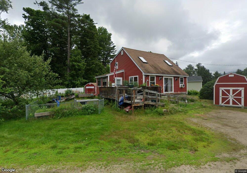
20 Young St North Woodstock, NH 03262
Estimated Value: $369,000 - $481,000
3
Beds
2
Baths
1,219
Sq Ft
$337/Sq Ft
Est. Value
About This Home
This home is located at 20 Young St, North Woodstock, NH 03262 and is currently estimated at $411,408, approximately $337 per square foot. 20 Young St is a home located in Grafton County with nearby schools including Lin-Wood Public Elementary School.
Ownership History
Date
Name
Owned For
Owner Type
Purchase Details
Closed on
Dec 4, 2018
Sold by
Hollenback Mark A
Bought by
Hollenback Mark A and Hollenbach Laurie J
Current Estimated Value
Purchase Details
Closed on
Jun 22, 2017
Sold by
Hollenback Edna A
Bought by
Hollenback Mark A
Purchase Details
Closed on
Mar 21, 2006
Sold by
Dyer Rev Tr 1997
Bought by
Hollenbach Harry G and Hollenbach Edna A
Home Financials for this Owner
Home Financials are based on the most recent Mortgage that was taken out on this home.
Original Mortgage
$182,400
Interest Rate
6.27%
Mortgage Type
Purchase Money Mortgage
Create a Home Valuation Report for This Property
The Home Valuation Report is an in-depth analysis detailing your home's value as well as a comparison with similar homes in the area
Home Values in the Area
Average Home Value in this Area
Purchase History
| Date | Buyer | Sale Price | Title Company |
|---|---|---|---|
| Hollenback Mark A | -- | -- | |
| Hollenback Mark A | -- | -- | |
| Hollenbach Harry G | $192,000 | -- |
Source: Public Records
Mortgage History
| Date | Status | Borrower | Loan Amount |
|---|---|---|---|
| Previous Owner | Hollenbach Harry G | $178,682 | |
| Previous Owner | Hollenbach Harry G | $182,400 |
Source: Public Records
Tax History Compared to Growth
Tax History
| Year | Tax Paid | Tax Assessment Tax Assessment Total Assessment is a certain percentage of the fair market value that is determined by local assessors to be the total taxable value of land and additions on the property. | Land | Improvement |
|---|---|---|---|---|
| 2024 | $3,672 | $180,690 | $66,900 | $113,790 |
| 2023 | $3,513 | $180,690 | $66,900 | $113,790 |
| 2022 | $3,321 | $180,690 | $66,900 | $113,790 |
| 2021 | $3,433 | $180,690 | $66,900 | $113,790 |
| 2020 | $3,625 | $181,690 | $66,900 | $114,790 |
| 2019 | $138,621 | $148,330 | $60,900 | $87,430 |
| 2018 | $3,223 | $148,330 | $60,900 | $87,430 |
| 2016 | $2,950 | $148,330 | $60,900 | $87,430 |
| 2015 | $2,808 | $148,330 | $60,900 | $87,430 |
| 2014 | $2,812 | $148,860 | $59,300 | $89,560 |
| 2012 | $2,682 | $150,000 | $58,330 | $91,670 |
Source: Public Records
Map
Nearby Homes
- 17 Ridge Dr Unit A-14
- 23 Oakes St
- 11 Cascade Dr Unit 288
- 164 Deer Park Dr Unit 160D
- 164 Deer Park Dr Unit 161D
- 164 Deer Park Dr Unit 168D
- 156 Deer Park Dr Unit 135 A
- 206-011 Lost River Rd
- 56 Kancamagus Hwy
- 65 Riverfront Dr Unit 217
- 14 Monroe Dr Unit 92
- 45 Riverfront Dr Unit 242
- 6 Monroe Dr Unit 111
- 16 Riverfront Dr Unit 293
- 16 Riverfront Dr Unit 292
- 25 Main St
- 9 Moose Ln
- 252-254 Lost River Rd
- 34 Franklin St
- 5 Robin Rd Unit 1