200 Blake Rd Epping, NH 03042
Estimated Value: $658,735 - $877,000
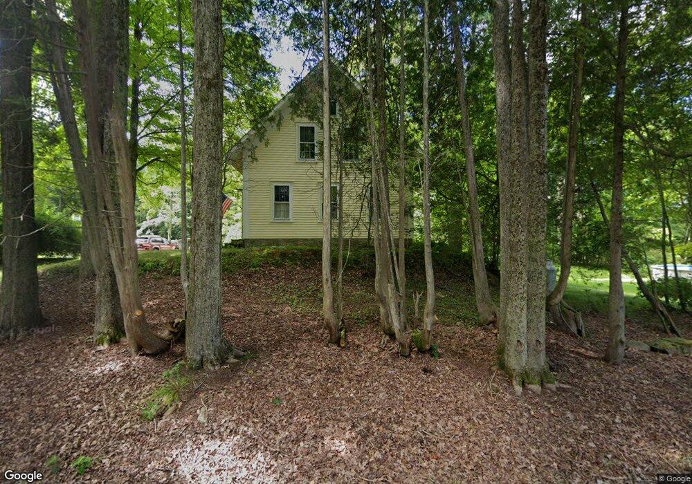
About This Home
This home is located at 200 Blake Rd, Epping, NH 03042 and is currently estimated at $754,934, approximately $288 per square foot. 200 Blake Rd is a home located in Rockingham County with nearby schools including Epping Elementary School, Epping Middle School, and Epping High School.
Ownership History
We collect this data history from publicly available records. To have your information removed, we recommend requesting removal directly through your county’s website.
Purchase Details
Home Values in the Area
Average Home Value in this Area
Purchase History
We collect this data history from publicly available records. To have your information removed, we recommend requesting removal directly through your county’s website.
| Date | Buyer | Sale Price | Title Company |
|---|---|---|---|
| -- | -- |
Mortgage History
We collect this data history from publicly available records. To have your information removed, we recommend requesting removal directly through your county’s website.
| Date | Status | Borrower | Loan Amount |
|---|---|---|---|
| Open | $133,000 | ||
| Closed | $36,000 |
Tax History
We collect this data history from publicly available records. To have your information removed, we recommend requesting removal directly through your county’s website.
| Year | Tax Paid | Tax Assessment Tax Assessment Total Assessment is a certain percentage of the fair market value that is determined by local assessors to be the total taxable value of land and additions on the property. | Land | Improvement |
|---|---|---|---|---|
| 2025 | $8,496 | $566,400 | $208,300 | $358,100 |
| 2024 | $8,624 | $341,800 | $127,300 | $214,500 |
| 2023 | $7,998 | $341,800 | $127,300 | $214,500 |
| 2022 | $7,687 | $341,800 | $127,300 | $214,500 |
| 2021 | $7,511 | $335,000 | $127,300 | $207,700 |
| 2020 | $7,919 | $335,000 | $127,300 | $207,700 |
| 2019 | $8,800 | $317,700 | $109,200 | $208,500 |
| 2018 | $8,241 | $317,700 | $109,200 | $208,500 |
| 2017 | $6,464 | $317,700 | $109,200 | $208,500 |
| 2016 | $8,241 | $317,700 | $109,200 | $208,500 |
| 2015 | $8,241 | $317,700 | $109,200 | $208,500 |
| 2014 | $7,861 | $321,900 | $109,200 | $212,700 |
| 2013 | $7,813 | $321,900 | $109,200 | $212,700 |
Map
- 105 Megans Way
- 101 Megans Way Unit 101
- 102 Megans Way
- 97 Megans Way Unit 97
- 7 Cortland Dr
- 29 Cider St
- 30 Stone Post Cir
- Lot 12 Pawtuckaway Ridge Unit Lot 12
- 21 Brustle Rd
- 24 Mountain Rd
- 3B Connor Ct Unit 3B
- 55 Sunset Ridge Rd Unit 55A
- 55 Sunset Ridge Rd Unit 55B
- 58 Arrow Ln
- 54 Sunset Ridge Rd Unit 54B
- 4 Norris Farm Rd
- 11 Nathaniel Dr
- 1A Connor Ct Unit 1A
- 25 Mooers Rd
- 1B Connor Ct Unit 1B
Ask me questions while you tour the home.