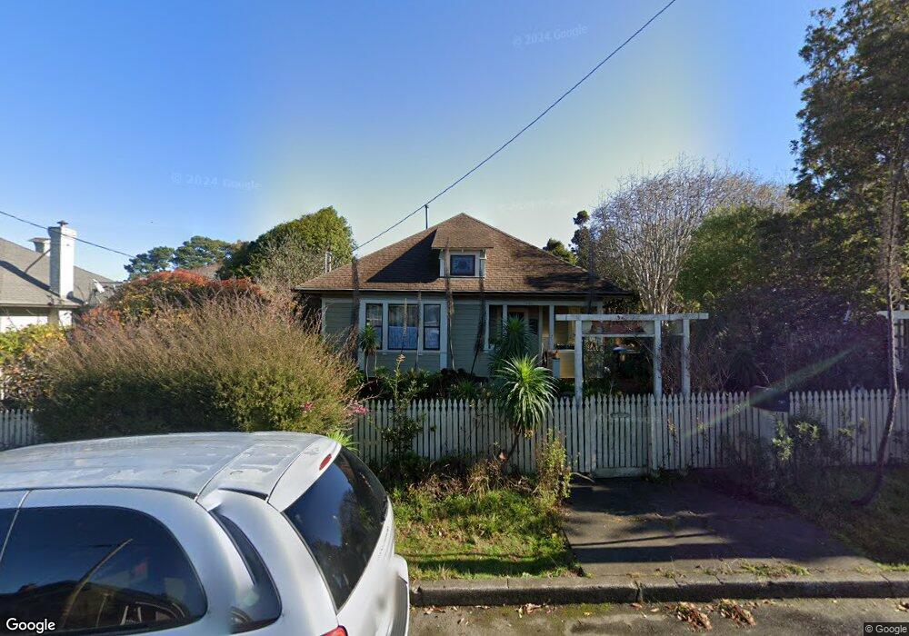
200 Brandon Way Fort Bragg, CA 95437
Estimated Value: $427,000 - $668,000
Studio
--
Bath
--
Sq Ft
7,405
Sq Ft
About This Home
This home is located at 200 Brandon Way, Fort Bragg, CA 95437 and is currently estimated at $520,334. 200 Brandon Way is a home located in Mendocino County with nearby schools including Fort Bragg High School and Three Rivers Charter School.
Ownership History
Date
Name
Owned For
Owner Type
Purchase Details
Closed on
May 30, 2017
Sold by
Haun Judith L and Haun Judy L
Bought by
Haun Judith L
Current Estimated Value
Purchase Details
Closed on
Oct 10, 2000
Sold by
Sumvan Sumvan Thy Thy and Sumvan Hooper Thy
Bought by
Sumvan Thy and Cline Larry B
Purchase Details
Closed on
Oct 6, 2000
Sold by
Castor Richard Arthur
Bought by
Castor Richard Arthur and Castor Richard Arthur
Purchase Details
Closed on
Sep 22, 2000
Sold by
Calder Chris
Bought by
Calder Lynn Weinerman
Purchase Details
Closed on
Dec 9, 1998
Sold by
Haun Helen
Bought by
Haun Judy L
Create a Home Valuation Report for This Property
The Home Valuation Report is an in-depth analysis detailing your home's value as well as a comparison with similar homes in the area
Home Values in the Area
Average Home Value in this Area
Purchase History
| Date | Buyer | Sale Price | Title Company |
|---|---|---|---|
| Haun Judith L | -- | None Available | |
| Sumvan Thy | -- | -- | |
| Castor Richard Arthur | -- | -- | |
| Calder Lynn Weinerman | -- | First American Title Co | |
| Haun Judy L | -- | Redwood Empire Title Company |
Source: Public Records
Tax History
| Year | Tax Paid | Tax Assessment Tax Assessment Total Assessment is a certain percentage of the fair market value that is determined by local assessors to be the total taxable value of land and additions on the property. | Land | Improvement |
|---|---|---|---|---|
| 2025 | $1,931 | $164,383 | $23,083 | $141,300 |
| 2023 | $1,931 | $158,002 | $22,188 | $135,814 |
| 2022 | $1,919 | $154,904 | $21,753 | $133,151 |
| 2021 | $1,813 | $151,868 | $21,327 | $130,541 |
| 2020 | $1,777 | $150,371 | $21,133 | $129,238 |
| 2019 | $1,754 | $147,424 | $20,719 | $126,705 |
| 2018 | $1,731 | $144,533 | $20,313 | $124,220 |
| 2017 | $1,548 | $141,700 | $19,914 | $121,786 |
| 2016 | $1,517 | $138,923 | $19,524 | $119,399 |
| 2015 | $1,492 | $136,836 | $19,231 | $117,605 |
| 2014 | $1,451 | $134,156 | $18,854 | $115,302 |
Source: Public Records
Map
Nearby Homes
- 119 E Pine St
- 1002 Cedar St
- 131 Halsey Way
- 210 S Mcpherson St
- 215 S Sanderson Way
- 104 Dana St
- 102 Dana St
- 459 S Mcpherson St
- 517 S Lincoln St
- 137 Olsen Ln
- 227 Hocker Ln
- 575 S Whipple St
- 1261 N Main St
- 19701 Noyo Acres Dr
- 19351 Del Mar Dr
- 19400 Dorffi Rd
- 19171 S Harbor Dr
- 19204 Benson Ln
- 14875 Atkins
- 32875 Simpson Ln
- 160 Brandon Way
- 210 Brandon Way
- 220 Brandon Way
- 655 N Harold St
- 659 N Harold St
- 205 Brandon Way
- 661 N Harold St
- 161 Brandon Way
- 222 Brandon Way
- 225 Brandon Way
- 645 N Harold St
- 230 Brandon Way
- 145 Brandon Way
- 669 N Harold St
- 233 Brandon Way
- 627 N Harold St
- 660 N Harold St
- 131 Brandon Way
- 650 N Harold St
- 619 E Fir St
Your Personal Tour Guide
Ask me questions while you tour the home.