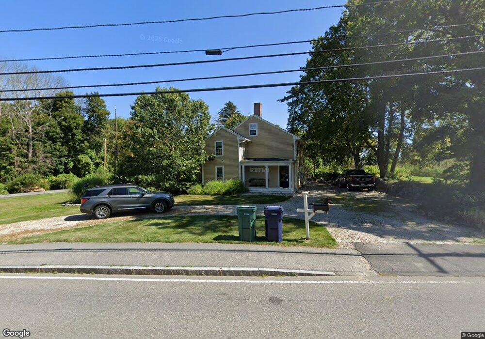
200 Country Way Scituate, MA 02066
Estimated Value: $931,000 - $997,000
4
Beds
2
Baths
2,903
Sq Ft
$333/Sq Ft
Est. Value
About This Home
This home is located at 200 Country Way, Scituate, MA 02066 and is currently estimated at $967,646, approximately $333 per square foot. 200 Country Way is a home located in Plymouth County with nearby schools including Cushing Elementary School, Lester J. Gates Middle School, and Scituate High School.
Ownership History
Date
Name
Owned For
Owner Type
Purchase Details
Closed on
Feb 16, 2024
Sold by
Litchfield Stephen S and Litchfield Martha J
Bought by
Walo
Current Estimated Value
Purchase Details
Closed on
Aug 1, 2002
Sold by
Mitchell Rt and Mitchell
Bought by
Litchfield Stephen S and Litchfield Martha J
Purchase Details
Closed on
Jun 19, 2002
Sold by
Mitchell Rt and Mitchell
Bought by
Walo Keith E and Walo Colleen A
Create a Home Valuation Report for This Property
The Home Valuation Report is an in-depth analysis detailing your home's value as well as a comparison with similar homes in the area
Home Values in the Area
Average Home Value in this Area
Purchase History
| Date | Buyer | Sale Price | Title Company |
|---|---|---|---|
| Walo | -- | None Available | |
| Walo | -- | None Available | |
| Litchfield Stephen S | $100,000 | -- | |
| Litchfield Stephen S | $100,000 | -- | |
| Walo Keith E | $250,000 | -- | |
| Walo Keith E | $250,000 | -- |
Source: Public Records
Mortgage History
| Date | Status | Borrower | Loan Amount |
|---|---|---|---|
| Previous Owner | Walo Keith E | $175,000 | |
| Previous Owner | Walo Keith E | $50,000 | |
| Previous Owner | Walo Keith E | $333,700 |
Source: Public Records
Tax History Compared to Growth
Tax History
| Year | Tax Paid | Tax Assessment Tax Assessment Total Assessment is a certain percentage of the fair market value that is determined by local assessors to be the total taxable value of land and additions on the property. | Land | Improvement |
|---|---|---|---|---|
| 2025 | $7,419 | $742,600 | $401,600 | $341,000 |
| 2024 | $7,550 | $728,800 | $365,100 | $363,700 |
| 2023 | $7,530 | $674,800 | $350,400 | $324,400 |
| 2022 | $7,530 | $596,700 | $323,600 | $273,100 |
| 2021 | $6,305 | $473,000 | $308,200 | $164,800 |
| 2020 | $6,238 | $462,100 | $296,300 | $165,800 |
| 2019 | $6,253 | $455,100 | $290,500 | $164,600 |
| 2018 | $6,388 | $457,900 | $275,700 | $182,200 |
| 2017 | $6,283 | $445,900 | $263,700 | $182,200 |
| 2016 | $5,967 | $422,000 | $239,800 | $182,200 |
| 2015 | $5,528 | $422,000 | $239,800 | $182,200 |
Source: Public Records
Map
Nearby Homes
- 115 Elm St
- 111 Elm St
- 12 Sassamon Rd
- 290 Beaver Dam Rd
- 18 James Way
- 19 Ford Place Unit 3
- 19 Ford Place Unit 1
- 19 Ford Place Unit 4
- 116 Old Forge Rd
- 17 Old Oaken Bucket Rd
- 74 Tilden Rd
- 76 A Brook St
- 76 A Brook St Unit 1
- 49 Cornet Stetson Rd
- 29 Ladds Way Unit 29
- 13 Hornbeam Rd
- 50 First Parish Rd
- 67 Greenfield Ln
- 59 Greenfield Ln
- 148 Tilden Rd
- 200 Country Way
- 205 Country Way
- 199 Country Way
- 211 Country Way
- 204 Country Way
- 204 Country Way
- 188 Country Way
- 188 Country Way
- 191 Country Way
- 215 Country Way
- 184 Country Way
- 184 Country Way
- 181 Country Way
- 11 Hughey Rd
- 9 Hughey Rd
- 9 Hughey Rd Unit 9
- 9 Hughey Rd Unit 11
- 1 Ross Arnold Ln
- 178 Country Way
- 178 Country Way