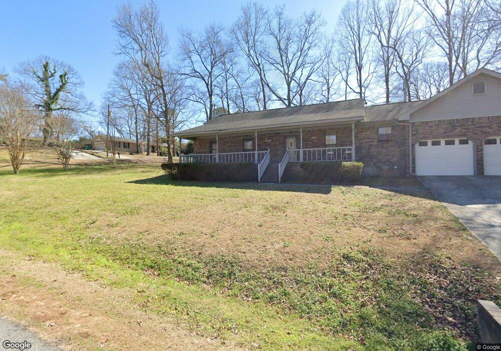
200 Debbie Dr Warner Robins, GA 31093
Estimated Value: $162,000 - $201,854
3
Beds
2
Baths
1,486
Sq Ft
$127/Sq Ft
Est. Value
About This Home
This home is located at 200 Debbie Dr, Warner Robins, GA 31093 and is currently estimated at $188,214, approximately $126 per square foot. 200 Debbie Dr is a home located in Houston County with nearby schools including Westside Elementary School, Northside Middle School, and Northside High School.
Ownership History
Date
Name
Owned For
Owner Type
Purchase Details
Closed on
Feb 8, 2017
Sold by
Carter William H
Bought by
Jordan Norma
Current Estimated Value
Home Financials for this Owner
Home Financials are based on the most recent Mortgage that was taken out on this home.
Original Mortgage
$84,096
Outstanding Balance
$64,274
Interest Rate
4.12%
Mortgage Type
FHA
Estimated Equity
$123,941
Purchase Details
Closed on
Jan 21, 2016
Sold by
Carter William H
Bought by
Carter William H and Carter Sue Ellen
Purchase Details
Closed on
Jan 21, 2003
Sold by
Carter William H
Bought by
Carter William H
Purchase Details
Closed on
Apr 8, 1991
Sold by
Carter William H and Carter Mary J
Bought by
Carter William H and Carter William H
Purchase Details
Closed on
Sep 10, 1971
Sold by
Pike David F
Bought by
Carter William H and Carter Mary J
Create a Home Valuation Report for This Property
The Home Valuation Report is an in-depth analysis detailing your home's value as well as a comparison with similar homes in the area
Home Values in the Area
Average Home Value in this Area
Purchase History
| Date | Buyer | Sale Price | Title Company |
|---|---|---|---|
| Jordan Norma | $87,000 | -- | |
| Carter William H | -- | -- | |
| Carter William H | -- | -- | |
| Carter William H | -- | -- | |
| Carter William H | -- | -- |
Source: Public Records
Mortgage History
| Date | Status | Borrower | Loan Amount |
|---|---|---|---|
| Open | Jordan Norma | $84,096 |
Source: Public Records
Tax History Compared to Growth
Tax History
| Year | Tax Paid | Tax Assessment Tax Assessment Total Assessment is a certain percentage of the fair market value that is determined by local assessors to be the total taxable value of land and additions on the property. | Land | Improvement |
|---|---|---|---|---|
| 2024 | $1,304 | $54,520 | $4,320 | $50,200 |
| 2023 | $1,061 | $43,880 | $3,720 | $40,160 |
| 2022 | $946 | $39,160 | $3,000 | $36,160 |
| 2021 | $844 | $34,720 | $3,000 | $31,720 |
| 2020 | $843 | $34,520 | $3,000 | $31,520 |
| 2019 | $843 | $34,520 | $3,000 | $31,520 |
| 2018 | $843 | $34,520 | $3,000 | $31,520 |
| 2017 | $843 | $34,520 | $3,000 | $31,520 |
| 2016 | $845 | $34,520 | $3,000 | $31,520 |
| 2015 | $846 | $34,520 | $3,000 | $31,520 |
| 2014 | -- | $34,520 | $3,000 | $31,520 |
| 2013 | -- | $34,520 | $3,000 | $31,520 |
Source: Public Records
Map
Nearby Homes
- 221 Gilchrist Dr
- 725 B East Side Dr
- 501 Pinecrest Dr
- 111 Hawthorne Rd
- 110 Foxfire Dr
- 303 Pinecrest Dr
- 123 Tanglewood Dr
- 209 Knodishall Dr
- 110 Westcliff Cir Unit C
- 200 Ridgeland Dr
- 103 Westcliff Cir Unit A
- 103 Westcliff Cir Unit A
- 857 Ola Dr
- 106 Westcliff Cir
- 316 Meadowridge Dr
- 102 Williams St
- 102 Westcliff Center St Unit D
- 110 Westcliff Center St
- 86 Westcliff Cir
- 111 Oakridge Dr
- 201 Lumpkin Dr
- 203 Lumpkin Dr
- 118 Taylor St
- 402 Taylor St
- 400 Taylor St
- 205 Debbie Dr
- 308 Taylor St
- 200 Lumpkin Dr
- 103 Meadow Glen Ct
- 205 Lumpkin Dr
- 2011 Green St
- 101 Meadow Glen Ct
- 2013 Green St
- 306 Taylor St
- 202 Lumpkin Dr
- 207 Debbie Dr
- 106 Meadow Glen Ct
- 2015 Green St
- 201 Meadow Glen Ct
- 2017 Green St