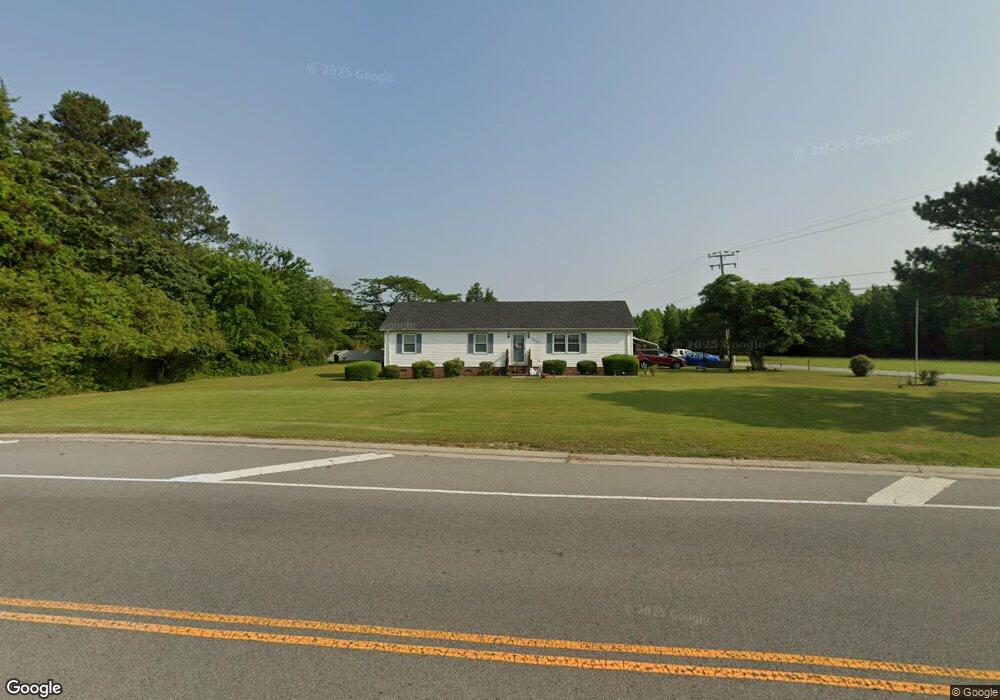
200 Kings Fork Rd Suffolk, VA 23434
Chuckatuck NeighborhoodEstimated Value: $309,000 - $356,000
3
Beds
2
Baths
1,643
Sq Ft
$206/Sq Ft
Est. Value
About This Home
This home is located at 200 Kings Fork Rd, Suffolk, VA 23434 and is currently estimated at $338,928, approximately $206 per square foot. 200 Kings Fork Rd is a home located in Suffolk City with nearby schools including Elephant's Fork Elementary School, King's Fork Middle School, and King's Fork High School.
Ownership History
Date
Name
Owned For
Owner Type
Purchase Details
Closed on
Jul 26, 2017
Sold by
The Estate Of Hannah Wilson Hogan
Bought by
Preneta Edward L and Preneta Elizabeth M
Current Estimated Value
Home Financials for this Owner
Home Financials are based on the most recent Mortgage that was taken out on this home.
Original Mortgage
$206,600
Outstanding Balance
$172,159
Interest Rate
3.91%
Mortgage Type
VA
Estimated Equity
$166,769
Create a Home Valuation Report for This Property
The Home Valuation Report is an in-depth analysis detailing your home's value as well as a comparison with similar homes in the area
Home Values in the Area
Average Home Value in this Area
Purchase History
| Date | Buyer | Sale Price | Title Company |
|---|---|---|---|
| Preneta Edward L | $200,000 | Titlequest Of Hampton Rd Llc |
Source: Public Records
Mortgage History
| Date | Status | Borrower | Loan Amount |
|---|---|---|---|
| Open | Preneta Edward L | $206,600 |
Source: Public Records
Tax History Compared to Growth
Tax History
| Year | Tax Paid | Tax Assessment Tax Assessment Total Assessment is a certain percentage of the fair market value that is determined by local assessors to be the total taxable value of land and additions on the property. | Land | Improvement |
|---|---|---|---|---|
| 2024 | $3,675 | $288,100 | $55,200 | $232,900 |
| 2023 | $3,476 | $280,600 | $55,200 | $225,400 |
| 2022 | $2,706 | $248,300 | $55,200 | $193,100 |
| 2021 | $2,396 | $215,900 | $55,200 | $160,700 |
| 2020 | $2,345 | $211,300 | $55,200 | $156,100 |
| 2019 | $2,236 | $201,400 | $55,200 | $146,200 |
| 2018 | $1,270 | $204,500 | $55,200 | $149,300 |
| 2017 | $1,932 | $180,600 | $55,200 | $125,400 |
| 2016 | $1,932 | $180,600 | $55,200 | $125,400 |
| 2015 | $136 | $180,600 | $55,200 | $125,400 |
| 2014 | $136 | $180,600 | $55,200 | $125,400 |
Source: Public Records
Map
Nearby Homes
- 121 Blessing Cir
- 201 Station Dr
- 286 Mccormick Dr
- 102 Chalmers Dr
- 279 Mccormick Dr
- 253 Mccormick Dr
- 105 Allis Dr
- 265 Mccormick Dr
- 269 Mccormick Dr
- 147 Squire Reach
- 152 Squire Reach
- 1056 Boundary Dr
- 285 Wexford Dr W
- 2060 Queens Point Dr
- 5014 Kings Grant Cir
- 5002 Westfalen Ct
- 5073 Kings Grant Cir
- 5061 Kings Grant Cir
- 1007 Robinson Rd Unit 4C
- 1011 Robinson Rd Unit 5D
- 200 Fings Fork
- 3301 Waters Ave
- 198 Kings Fork Rd
- 300 Kings Fork Rd
- 3321 Waters Ave
- 3353 Waters Ave
- 3365 Waters Ave
- 3348 Waters Ave
- 3349 Waters Ave
- 3309 Waters Ave
- 350 Kings Fork Rd
- 234 Tassell Crescent
- 230 Tassell Crescent
- 3409 Waters Ave
- 229 Tassell Crescent
- MM County Road 634
- 224 Tassell Crescent
- 222 Station Dr
- 220 Station Dr
- 222 Tassell Crescent