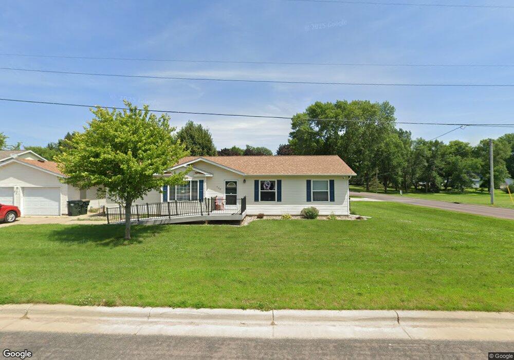
200 NW 5th St Elysian, MN 56028
Estimated Value: $271,000 - $423,000
3
Beds
3
Baths
1,512
Sq Ft
$217/Sq Ft
Est. Value
About This Home
This home is located at 200 NW 5th St, Elysian, MN 56028 and is currently estimated at $327,522, approximately $216 per square foot. 200 NW 5th St is a home located in Le Sueur County with nearby schools including Waterville Elementary School, Morristown Elementary School, and Waterville-Elysian-Morristown Junior High School.
Ownership History
Date
Name
Owned For
Owner Type
Purchase Details
Closed on
Jul 29, 2013
Sold by
Nu Horizons Of Southern Mn Llc
Bought by
Nu Horizons Holdiings Llc
Current Estimated Value
Purchase Details
Closed on
May 11, 2012
Sold by
Flitter Ivan and Flitter Sandra
Bought by
Nu Horizons Of Southern Mn Llc
Purchase Details
Closed on
Jul 31, 2006
Sold by
Mcmenomy Sean P and Mcmenomy Jessica
Bought by
Flitter Ivan and Flitter Sandra
Create a Home Valuation Report for This Property
The Home Valuation Report is an in-depth analysis detailing your home's value as well as a comparison with similar homes in the area
Purchase History
| Date | Buyer | Sale Price | Title Company |
|---|---|---|---|
| Nu Horizons Holdiings Llc | -- | -- | |
| Nu Horizons Of Southern Mn Llc | -- | Minnesota River Valley Title | |
| Nu Horizons Of Southern Mn | $175,000 | -- | |
| Flitter Ivan | $150,000 | -- |
Source: Public Records
Tax History
| Year | Tax Paid | Tax Assessment Tax Assessment Total Assessment is a certain percentage of the fair market value that is determined by local assessors to be the total taxable value of land and additions on the property. | Land | Improvement |
|---|---|---|---|---|
| 2025 | $3,898 | $292,400 | $36,300 | $256,100 |
| 2024 | $3,636 | $280,900 | $36,300 | $244,600 |
| 2023 | $3,692 | $272,800 | $36,300 | $236,500 |
| 2022 | $3,290 | $271,200 | $36,300 | $234,900 |
| 2021 | $3,292 | $206,300 | $31,300 | $175,000 |
| 2020 | $3,304 | $199,500 | $29,300 | $170,200 |
| 2019 | $3,404 | $199,500 | $29,300 | $170,200 |
| 2018 | $3,389 | $199,500 | $29,300 | $170,200 |
| 2017 | $2,525 | $168,600 | $27,300 | $141,300 |
| 2016 | $2,172 | $166,700 | $27,300 | $139,400 |
| 2015 | $2,157 | $145,300 | $27,300 | $118,000 |
| 2014 | $2,025 | $152,000 | $27,300 | $124,700 |
| 2013 | $1,942 | $141,000 | $27,300 | $113,700 |
Source: Public Records
Map
Nearby Homes
- 0 Xx Lewis Ln Unit 7025397
- 0 Xx Lewis Ln Unit 7025381
- xx Lewis Ln
- xxxxxx Lewis Ln
- -XX Jason Dr
- 13 Egret Ln
- 101 Shoreview Dr
- 121 Willow Point Dr
- 125 Willow Point Dr
- 2 Marie Cir
- 3271 425th Ave
- 49279 Sportsmans Ln
- 49189 Sportsmans Ln
- 48901 N Shore Rd
- 0 N Shore Rd
- 16965 Dickenson Ln
- 707 Tetonka View Dr
- 921 Lillian St
- 918 Marian St
- 902 Marion St
- 406 NW Park Ave
- 202 NW 5th St
- 101 5th St NW
- 205 4th St NW
- 205 NW 4th St
- TBD NW 5th St
- 403 NW Frank Ave
- 0 Tbd Nw 5th Unit 7026603
- 101 NW 4th St
- 101 4th St NW
- 207 4th St NW
- 400 W Main St
- 304 Park Ave NW
- 406 NW Frank Ave
- 102 NW 4th St
- 402 NW Frank Ave
- 301 NW 5th St
- 202 NW 4th St
- 504 Frank Ave NW
- 301 NW 4th St
Your Personal Tour Guide
Ask me questions while you tour the home.