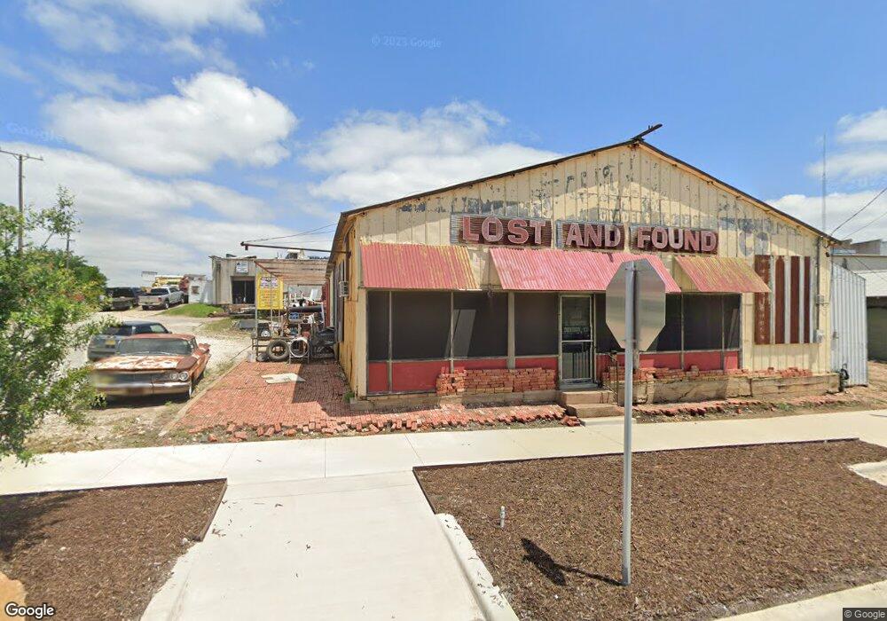
200 S Houston Ave Denison, TX 75021
Downtown Denison Neighborhood
--
Bed
--
Bath
3,300
Sq Ft
9,148
Sq Ft Lot
About This Home
This home is located at 200 S Houston Ave, Denison, TX 75021. 200 S Houston Ave is a home located in Grayson County with nearby schools including Terrell Elementary School, Scott Middle School, and Denison High School.
Ownership History
Date
Name
Owned For
Owner Type
Purchase Details
Closed on
Aug 21, 2015
Sold by
Abston Brian
Bought by
Dorris Laramie and Dorris Brooke K
Home Financials for this Owner
Home Financials are based on the most recent Mortgage that was taken out on this home.
Original Mortgage
$30,885
Outstanding Balance
$24,332
Interest Rate
4.08%
Mortgage Type
Future Advance Clause Open End Mortgage
Purchase Details
Closed on
Nov 4, 2011
Sold by
Guymon Greg
Bought by
Abston Brian
Home Financials for this Owner
Home Financials are based on the most recent Mortgage that was taken out on this home.
Original Mortgage
$45,000
Interest Rate
4.14%
Mortgage Type
Commercial
Purchase Details
Closed on
Nov 8, 2010
Sold by
Dotson Robert Edward and Dotson Christy Ann
Bought by
Guymon Greg
Create a Home Valuation Report for This Property
The Home Valuation Report is an in-depth analysis detailing your home's value as well as a comparison with similar homes in the area
Home Values in the Area
Average Home Value in this Area
Purchase History
| Date | Buyer | Sale Price | Title Company |
|---|---|---|---|
| Dorris Laramie | -- | Grayson County Title | |
| Abston Brian | -- | Grayson County Title | |
| Guymon Greg | -- | Red River Title Co |
Source: Public Records
Mortgage History
| Date | Status | Borrower | Loan Amount |
|---|---|---|---|
| Open | Dorris Laramie | $30,885 | |
| Previous Owner | Abston Brian | $45,000 |
Source: Public Records
Tax History Compared to Growth
Tax History
| Year | Tax Paid | Tax Assessment Tax Assessment Total Assessment is a certain percentage of the fair market value that is determined by local assessors to be the total taxable value of land and additions on the property. | Land | Improvement |
|---|---|---|---|---|
| 2025 | $3,325 | $238,624 | $171,347 | $67,277 |
| 2024 | $3,325 | $143,108 | $0 | $0 |
| 2023 | $2,702 | $119,257 | $43,006 | $76,251 |
| 2022 | $2,053 | $86,397 | $43,006 | $43,391 |
| 2021 | $2,018 | $80,000 | $18,122 | $61,878 |
| 2020 | $1,904 | $72,201 | $18,122 | $54,079 |
| 2019 | $1,987 | $72,201 | $8,120 | $64,081 |
| 2018 | $2,003 | $72,201 | $6,767 | $65,434 |
| 2017 | $1,896 | $67,758 | $6,767 | $60,991 |
| 2016 | $1,896 | $67,758 | $6,767 | $60,991 |
| 2015 | $1,512 | $53,532 | $6,767 | $46,765 |
| 2014 | $1,328 | $47,003 | $6,767 | $40,236 |
Source: Public Records
Map
Nearby Homes
- 1046 E Owings St
- 200 E Morgan St
- 215 E Nelson St
- 117 W Sears St
- 410 N Houston Ave
- 108 E Nelson St
- 0 E Nelson St
- 330 W Morgan St
- 110 W Morton St
- 105 E Morton St
- 718 E Woodard St
- 720 E Woodard St
- 121 W Morton St
- 117 W Morton St
- 512 E Gandy St
- 506 W Woodard St
- 522 N Austin Ave
- 716 N Rusk Ave
- 401 E Morton St
- 205 W Bond St
- 9 W Chestnut St
- 103 E Crawford St
- 117 S Houston Ave
- 106 S Houston Ave
- 118 W Chestnut St
- 120 W Chestnut St
- 25 W Main St
- 26 W Main St
- 24 W Main St
- 118 W Main St Unit 1
- 118 W Main St
- 118 W Main St Unit 201
- 120 W Main St
- 124 W Main St Unit 201
- 128 W Main St
- 101 W Main St
- 111 W Main St
- 130 W Main St
- 130 W Crawford St
- 119 W Main St