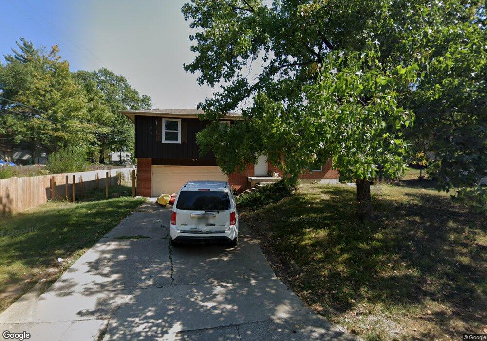
200 Snead Dr Columbia, MO 65202
Estimated Value: $196,000 - $260,000
3
Beds
2
Baths
1,416
Sq Ft
$157/Sq Ft
Est. Value
About This Home
This home is located at 200 Snead Dr, Columbia, MO 65202 and is currently estimated at $222,746, approximately $157 per square foot. 200 Snead Dr is a home located in Boone County with nearby schools including Eliot Battle Elementary School, John B. Lange Middle School, and Muriel W. Battle High School.
Ownership History
Date
Name
Owned For
Owner Type
Purchase Details
Closed on
Jan 9, 2023
Sold by
Christian And Andrew Llc
Bought by
Regina Meaghan
Current Estimated Value
Purchase Details
Closed on
May 19, 2022
Sold by
Andrew Nilson
Bought by
Christian And Andrew Llc
Purchase Details
Closed on
Feb 7, 2022
Sold by
Ann Audsley Marjorie
Bought by
Nilson Andrew
Home Financials for this Owner
Home Financials are based on the most recent Mortgage that was taken out on this home.
Original Mortgage
$78,400
Interest Rate
3.56%
Mortgage Type
New Conventional
Create a Home Valuation Report for This Property
The Home Valuation Report is an in-depth analysis detailing your home's value as well as a comparison with similar homes in the area
Home Values in the Area
Average Home Value in this Area
Purchase History
| Date | Buyer | Sale Price | Title Company |
|---|---|---|---|
| Regina Meaghan | -- | -- | |
| Christian And Andrew Llc | -- | None Listed On Document | |
| Nilson Andrew | -- | None Listed On Document |
Source: Public Records
Mortgage History
| Date | Status | Borrower | Loan Amount |
|---|---|---|---|
| Previous Owner | Nilson Andrew | $78,400 |
Source: Public Records
Tax History Compared to Growth
Tax History
| Year | Tax Paid | Tax Assessment Tax Assessment Total Assessment is a certain percentage of the fair market value that is determined by local assessors to be the total taxable value of land and additions on the property. | Land | Improvement |
|---|---|---|---|---|
| 2025 | $1,356 | $18,753 | $2,850 | $15,903 |
| 2024 | $1,356 | $18,753 | $2,850 | $15,903 |
| 2023 | $1,345 | $18,753 | $2,850 | $15,903 |
| 2022 | $1,344 | $18,753 | $2,850 | $15,903 |
| 2021 | $1,346 | $18,753 | $2,850 | $15,903 |
| 2020 | $1,320 | $17,366 | $2,850 | $14,516 |
| 2019 | $1,320 | $17,366 | $2,850 | $14,516 |
| 2018 | $1,329 | $0 | $0 | $0 |
| 2017 | $1,313 | $17,366 | $2,850 | $14,516 |
| 2016 | $1,311 | $17,366 | $2,850 | $14,516 |
| 2015 | $1,211 | $17,366 | $2,850 | $14,516 |
| 2014 | -- | $17,366 | $2,850 | $14,516 |
Source: Public Records
Map
Nearby Homes
- 6007 E Saint Charles Rd
- 6003 E St Charles Rd
- 1312 N Lake of the Woods Rd
- 1312 N Lake of the Wood
- 1537 N Lake of the Woods Rd
- 6077 E Locust Grove Dr
- 300 Searsport Dr
- 5800 Oswago Cir
- 5724 Black Gum Ct
- 1887 Waterfront Dr N Unit F
- 5802 Islip Dr
- 2032 Waterfront Dr N Unit C
- 1999 Waterfront Dr N Unit G
- 1999 Waterfront Dr N Unit H
- 1997 Waterfront Dr N Unit D
- 2009 Waterfront Dr N Unit E
- 2009 Waterfront Dr N Unit A1
- 6900 Armstrong Dr
- 5301 Gasconade Dr
- 2005 Waterfront Dr N Unit E
- 202 Snead Dr
- 6304 E Saint Charles Rd
- 301 Hogan Dr
- 6308 E Saint Charles Rd
- 303 Hogan Dr
- 204 Snead Dr
- 6310 E Saint Charles Rd
- 305 Hogan Dr
- 6212 E Saint Charles Rd
- 201 Snead Dr
- 203 Snead Dr
- 307 Hogan Dr
- 205 Snead Dr
- 6208 E Saint Charles Rd
- 300 Hogan Dr
- 302 Hogan Dr
- 309 Hogan Dr
- 1305 N Pin Oak Blvd
- 207 Snead Dr
- 1200-1202 Player Place