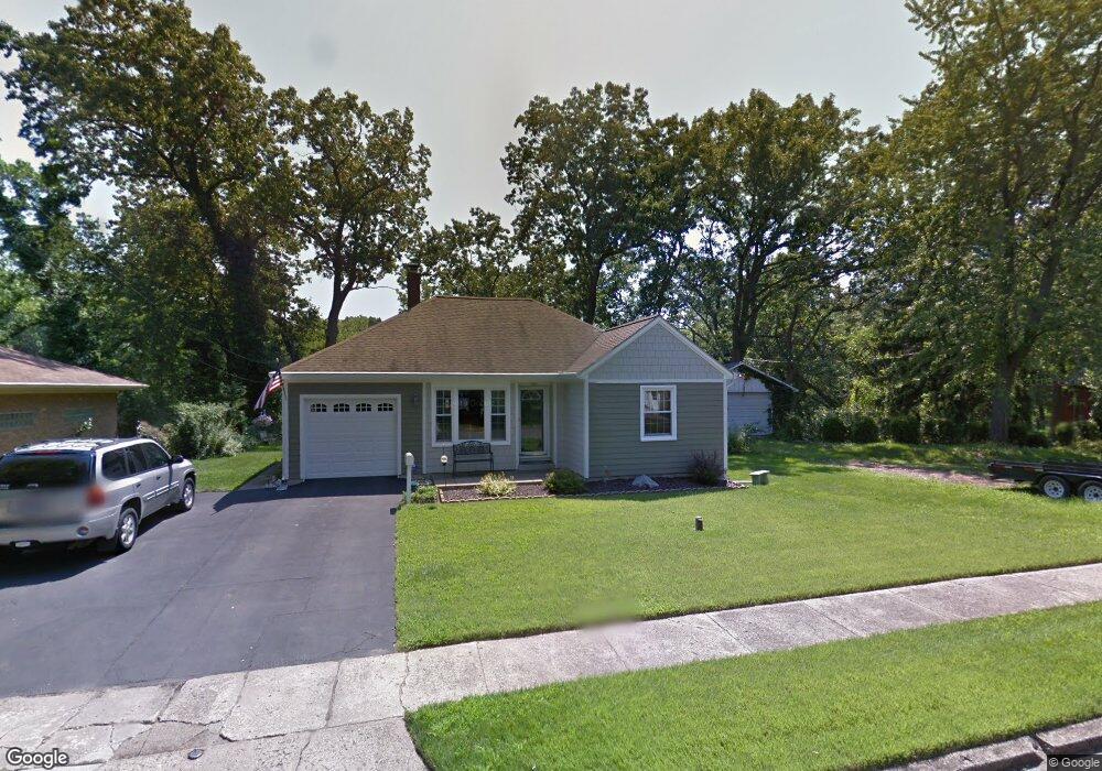
200 Windsor Rd Benton Harbor, MI 49022
Fair Plain NeighborhoodEstimated Value: $120,000 - $175,868
2
Beds
1
Bath
810
Sq Ft
$187/Sq Ft
Est. Value
About This Home
This home is located at 200 Windsor Rd, Benton Harbor, MI 49022 and is currently estimated at $151,467, approximately $186 per square foot. 200 Windsor Rd is a home located in Berrien County with nearby schools including Fair Plain Middle School, Benton Harbor High School, and Benton Harbor Charter School Academy.
Ownership History
Date
Name
Owned For
Owner Type
Purchase Details
Closed on
Mar 1, 2007
Sold by
Leist Scot M and Leist Karen
Bought by
Leist Scot M and Leist Karen
Current Estimated Value
Home Financials for this Owner
Home Financials are based on the most recent Mortgage that was taken out on this home.
Original Mortgage
$72,000
Outstanding Balance
$43,604
Interest Rate
6.27%
Mortgage Type
New Conventional
Estimated Equity
$107,863
Purchase Details
Closed on
Apr 28, 1995
Purchase Details
Closed on
May 28, 1991
Purchase Details
Closed on
Oct 1, 1975
Create a Home Valuation Report for This Property
The Home Valuation Report is an in-depth analysis detailing your home's value as well as a comparison with similar homes in the area
Home Values in the Area
Average Home Value in this Area
Purchase History
| Date | Buyer | Sale Price | Title Company |
|---|---|---|---|
| Leist Scot M | -- | Chicago Title | |
| -- | $46,500 | -- | |
| -- | $100 | -- | |
| -- | $10,500 | -- |
Source: Public Records
Mortgage History
| Date | Status | Borrower | Loan Amount |
|---|---|---|---|
| Open | Leist Scot M | $72,000 |
Source: Public Records
Tax History Compared to Growth
Tax History
| Year | Tax Paid | Tax Assessment Tax Assessment Total Assessment is a certain percentage of the fair market value that is determined by local assessors to be the total taxable value of land and additions on the property. | Land | Improvement |
|---|---|---|---|---|
| 2025 | $936 | $70,200 | $0 | $0 |
| 2024 | $550 | $60,500 | $0 | $0 |
| 2023 | $524 | $42,300 | $0 | $0 |
| 2022 | $499 | $40,100 | $0 | $0 |
| 2021 | $815 | $42,900 | $11,100 | $31,800 |
| 2020 | $760 | $43,000 | $0 | $0 |
| 2019 | $741 | $35,600 | $5,300 | $30,300 |
| 2018 | $684 | $35,600 | $0 | $0 |
| 2017 | $674 | $34,600 | $0 | $0 |
| 2016 | $651 | $34,900 | $0 | $0 |
| 2015 | $650 | $32,400 | $0 | $0 |
| 2014 | $423 | $34,600 | $0 | $0 |
Source: Public Records
Map
Nearby Homes
- 1235 Colfax Ave
- 202 Searles Ave
- 180 Emery Ave
- 377 Western Ave
- 379 Western Ave
- 979 Lavette Ave
- 941 Colfax Ave
- 1267 Broadway
- 513 N Ottawa Rd
- 1000 Riverview Dr Unit 11
- 171 E Empire Ave
- 872 Mcalister Ave
- 1097 Pearl St
- 361 E May St
- 1332 Columbus Ave
- 131 Clay St
- 1301 Superior St
- 349 E Empire Ave
- 424 W Napier Ave
- 1045 Broadway
- 188 Windsor Rd
- 191 Windsor Rd
- 185 Windsor Rd
- 211 Windsor Rd
- 211 Windsor Rd
- 222 Windsor Rd
- 175 Windsor Rd
- 170 Windsor Rd
- 223 Windsor Rd
- 228 Windsor Rd
- 220 Robbins Ave
- 192 Robbins Ave
- 200 Robbins Ave
- 235 Windsor Rd
- 162 Windsor Rd
- 169 Windsor Rd
- 230 Robbins Ave
- 184 Robbins Ave
- 168 Robbins Ave
- 153 Windsor Rd