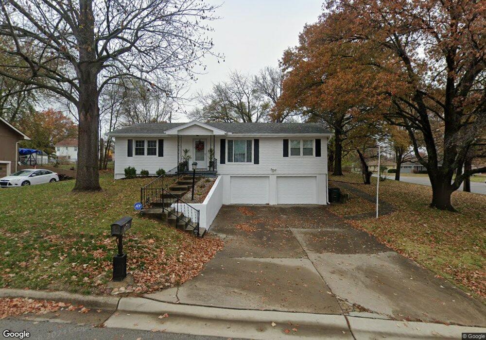
2000 Marjorie Cir Leavenworth, KS 66048
Estimated Value: $232,000 - $250,000
3
Beds
2
Baths
1,344
Sq Ft
$180/Sq Ft
Est. Value
About This Home
This home is located at 2000 Marjorie Cir, Leavenworth, KS 66048 and is currently estimated at $241,310, approximately $179 per square foot. 2000 Marjorie Cir is a home located in Leavenworth County with nearby schools including David Brewer Elementary School, Richard Warren Middle School, and Leavenworth Senior High School.
Ownership History
Date
Name
Owned For
Owner Type
Purchase Details
Closed on
Oct 1, 2002
Bought by
Jones Willie J and Jones Joyce E
Current Estimated Value
Home Financials for this Owner
Home Financials are based on the most recent Mortgage that was taken out on this home.
Original Mortgage
$149,000
Outstanding Balance
$116,275
Interest Rate
5.99%
Mortgage Type
VA
Estimated Equity
$125,035
Create a Home Valuation Report for This Property
The Home Valuation Report is an in-depth analysis detailing your home's value as well as a comparison with similar homes in the area
Home Values in the Area
Average Home Value in this Area
Purchase History
| Date | Buyer | Sale Price | Title Company |
|---|---|---|---|
| Jones Willie J | $116,000 | -- |
Source: Public Records
Mortgage History
| Date | Status | Borrower | Loan Amount |
|---|---|---|---|
| Open | Jones Willie J | $149,000 | |
| Closed | Jones Willie J | $133,784 |
Source: Public Records
Tax History Compared to Growth
Tax History
| Year | Tax Paid | Tax Assessment Tax Assessment Total Assessment is a certain percentage of the fair market value that is determined by local assessors to be the total taxable value of land and additions on the property. | Land | Improvement |
|---|---|---|---|---|
| 2025 | $2,685 | $24,187 | $3,260 | $20,927 |
| 2024 | $2,682 | $23,034 | $3,260 | $19,774 |
| 2023 | $2,682 | $22,364 | $3,260 | $19,104 |
| 2022 | $2,347 | $19,447 | $2,657 | $16,790 |
| 2021 | $2,206 | $17,113 | $2,657 | $14,456 |
| 2020 | $2,221 | $17,113 | $2,657 | $14,456 |
| 2019 | $2,202 | $16,814 | $2,657 | $14,157 |
| 2018 | $2,219 | $16,814 | $2,657 | $14,157 |
| 2017 | $2,090 | $15,997 | $2,657 | $13,340 |
| 2016 | $2,049 | $15,664 | $2,657 | $13,007 |
| 2015 | $1,913 | $14,729 | $2,657 | $12,072 |
| 2014 | $1,904 | $14,729 | $2,657 | $12,072 |
Source: Public Records
Map
Nearby Homes
- 401 S 20th St
- 1933 Cherokee St
- 2101 Spruce St
- 1919 Seneca St
- 905 S 17th St
- 1835 Miami St
- 938 S 17th St
- 204 N 17th St
- 318 N 18th St
- 1927 Pottawatomie St
- 1515 Kenton St
- 1504 Casey Ct
- 1519 Delaware St
- 1500 Sanders St
- 1844 Ottawa St
- 1405 Cherokee St
- 1340 Spruce St
- 1706 Ottawa St
- 914 Madison St
- 1240 Sanders St
- 2004 Marjorie Cir
- 2001 High St
- 2005 High St
- 2001 Marjorie Cir
- 2009 High St
- 701 S 20th St
- 2008 Marjorie Cir
- 2005 Marjorie Cir
- 709 S 20th St
- 2013 High St
- 2009 Marjorie Cir
- 1924 High Dr
- 717 S 20th St
- 1931 High Dr
- 2049 Marjorie Cir
- 2017 High St
- 2012 Marjorie Cir
- 2045 Marjorie Cir
- 2000 High St
- 2004 High St