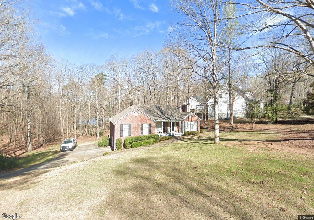
2000 Sterling Ct Lagrange, GA 30240
Estimated Value: $395,140 - $503,000
About This Home
This home is located at 2000 Sterling Ct, Lagrange, GA 30240 and is currently estimated at $458,035, approximately $241 per square foot. 2000 Sterling Ct is a home located in Troup County with nearby schools including Ethel W. Kight Elementary School, Hollis Hand Elementary School, and Franklin Forest Elementary School.
Ownership History
We collect this data history from publicly available records. To have your information removed, we recommend requesting removal directly through your county’s website.
Purchase Details
Purchase Details
Purchase Details
Purchase Details
Purchase Details
Purchase Details
Purchase Details
Purchase Details
Purchase History
We collect this data history from publicly available records. To have your information removed, we recommend requesting removal directly through your county’s website.
| Date | Buyer | Sale Price | Title Company |
|---|---|---|---|
| -- | -- | ||
| $320,000 | -- | ||
| $252,500 | -- | ||
| -- | -- | ||
| $167,500 | -- | ||
| $173,000 | -- | ||
| $13,500 | -- | ||
| -- | -- |
Tax History
We collect this data history from publicly available records. To have your information removed, we recommend requesting removal directly through your county’s website.
| Year | Tax Paid | Tax Assessment Tax Assessment Total Assessment is a certain percentage of the fair market value that is determined by local assessors to be the total taxable value of land and additions on the property. | Land | Improvement |
|---|---|---|---|---|
| 2025 | $4,748 | $183,840 | $34,000 | $149,840 |
| 2024 | $4,173 | $160,840 | $34,000 | $126,840 |
| 2023 | $3,837 | $148,520 | $34,000 | $114,520 |
| 2022 | $3,653 | $138,600 | $30,000 | $108,600 |
| 2021 | $3,487 | $123,360 | $30,000 | $93,360 |
| 2020 | $3,487 | $123,360 | $30,000 | $93,360 |
| 2019 | $3,149 | $112,160 | $19,360 | $92,800 |
| 2018 | $3,149 | $112,160 | $19,360 | $92,800 |
| 2017 | $3,149 | $112,160 | $19,360 | $92,800 |
| 2016 | $3,211 | $114,230 | $19,360 | $94,870 |
| 2015 | $3,211 | $114,230 | $19,360 | $94,870 |
| 2014 | $3,068 | $109,487 | $19,360 | $90,127 |
| 2013 | -- | $106,195 | $19,360 | $86,835 |
Map
- 1017 Riverside Dr
- 4004 White Oak Ln
- 134 N Lake Dr
- 506 Riverside Dr
- 110 Thomas Dr
- 103 Dogwood Ct
- 104 Dogwood Point
- 106 Mckinley Cir
- 102 Mckinley Cir
- 213 Linda Ln
- LOT 3 Post Oak Dr
- 105 + - Acres On McCosh Mill Rd
- 0 Deming St Unit 10550189
- 4.5 ACRES Whatley Rd N
- 300 Cheyenne Dr
- 214 Highland Trail
- 0 Neely Rd Unit 10776228
- 117 Brookwood Dr
- 82 Newton Rd
- 36 Hill Rd
- 1013 Riverside Dr
- 1015 Riverside Dr
- 2003 Sterling Ct
- 2001 Sterling Ct
- 2002 Sterling Ct
- 0 Riverside Dr Unit 80 8323214
- 5181/2 Riverside Dr
- 1012 Riverside Dr
- 154 N Lake Dr
- 1009 Riverside Dr
- 153 N Lake Dr
- 1008 Riverside Dr
- 3001 White Oak Ct
- 1007 Riverside Dr
- 152 N Lake Dr
- 1018 Riverside Dr
- 151 N Lake Dr
- 1006 Riverside Dr
- 3003 White Oak Ct
- 525 Riverside Dr
Ask me questions while you tour the home.