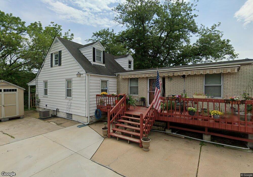
2001 Bopp Ave Middle River, MD 21220
Estimated Value: $322,000 - $347,000
Studio
2
Baths
1,596
Sq Ft
$210/Sq Ft
Est. Value
About This Home
This home is located at 2001 Bopp Ave, Middle River, MD 21220 and is currently estimated at $334,743, approximately $209 per square foot. 2001 Bopp Ave is a home located in Baltimore County with nearby schools including Middlesex Elementary School, Stemmers Run Middle School, and Kenwood High.
Ownership History
Date
Name
Owned For
Owner Type
Purchase Details
Closed on
Aug 1, 2001
Sold by
Gorschboth Eric
Bought by
Stickline Richard A and Stickline Stephanie A
Current Estimated Value
Purchase Details
Closed on
Apr 15, 1994
Sold by
Ford Victoria
Bought by
Gorschboth Eric 1
Home Financials for this Owner
Home Financials are based on the most recent Mortgage that was taken out on this home.
Original Mortgage
$80,000
Interest Rate
7.45%
Create a Home Valuation Report for This Property
The Home Valuation Report is an in-depth analysis detailing your home's value as well as a comparison with similar homes in the area
Home Values in the Area
Average Home Value in this Area
Purchase History
| Date | Buyer | Sale Price | Title Company |
|---|---|---|---|
| Stickline Richard A | $127,500 | -- | |
| Gorschboth Eric 1 | $80,000 | -- |
Source: Public Records
Mortgage History
| Date | Status | Borrower | Loan Amount |
|---|---|---|---|
| Open | Gorschboth Eric 1 | $106,332 | |
| Previous Owner | Gorschboth Eric 1 | $80,000 |
Source: Public Records
Tax History
| Year | Tax Paid | Tax Assessment Tax Assessment Total Assessment is a certain percentage of the fair market value that is determined by local assessors to be the total taxable value of land and additions on the property. | Land | Improvement |
|---|---|---|---|---|
| 2025 | $4,808 | $240,867 | -- | -- |
| 2024 | $4,808 | $213,733 | -- | -- |
| 2023 | $2,186 | $186,600 | $61,200 | $125,400 |
| 2022 | $3,766 | $184,433 | $0 | $0 |
| 2021 | $2,978 | $182,267 | $0 | $0 |
| 2020 | $2,978 | $180,100 | $61,200 | $118,900 |
| 2019 | $2,778 | $180,100 | $61,200 | $118,900 |
| 2018 | $2,678 | $180,100 | $61,200 | $118,900 |
| 2017 | $2,598 | $183,400 | $0 | $0 |
| 2016 | $2,418 | $180,200 | $0 | $0 |
| 2015 | $2,418 | $177,000 | $0 | $0 |
| 2014 | $2,418 | $173,800 | $0 | $0 |
Source: Public Records
Map
Nearby Homes
- 60 S Hawthorne Rd
- 13 Harrison Ave N
- 24 Harrison Ave N
- 215 Seamaster Rd
- 1812 Kitty Hawk Rd
- 1100 N Marlyn Ave
- 318 Grovethorn Rd
- 37 Walkern Rd
- 2151 Coralthorn Rd
- 214 Ballard Ave
- 2203 Coralthorn Rd
- 18 Blister St
- 2124 Redthorn Rd
- 1535 Chilworth Ave
- 236 Endsleigh Ave
- 33 Left Wing Dr
- 1201 Fuselage Ave
- 2162 Vailthorn Rd
- 1713 Glen Curtis Rd
- 1700 Old Eastern Ave
- 6 N Hawthorne Rd
- 8 N Hawthorne Rd
- 4 N Hawthorne Rd
- 10 N Hawthorne Rd
- 5 N Hawthorne Rd
- 1 Forest Rd
- 14 N Hawthorne Rd
- 11 N Hawthorne Rd
- 7 N Hawthorne Rd
- 2 Forest Rd
- 2100 Eastern Blvd
- 3 Forest Rd
- 2102 Eastern Blvd
- 16 N Hawthorne Rd
- 15 N Hawthorne Rd
- 2104 Old Eastern Ave
- 18 N Hawthorne Rd
- 5 Forest Rd
- 4 Forest Rd
- 2106 Old Eastern Ave
Your Personal Tour Guide
Ask me questions while you tour the home.