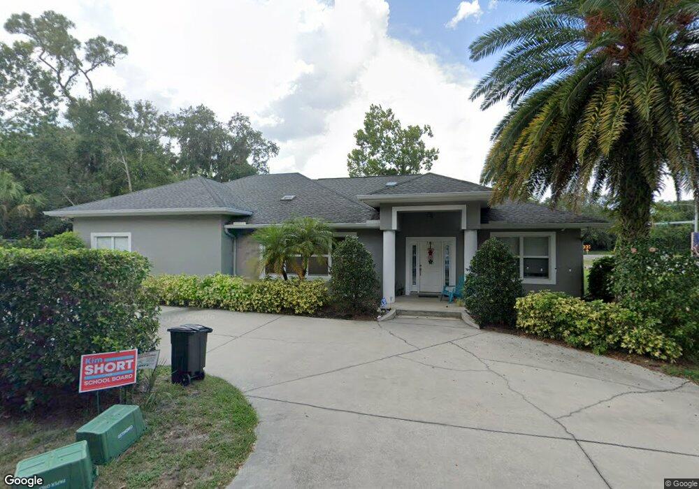
2001 Euclid St New Smyrna Beach, FL 32168
Ellison Acres NeighborhoodEstimated Value: $336,000 - $471,000
2
Beds
3
Baths
1,628
Sq Ft
$246/Sq Ft
Est. Value
About This Home
This home is located at 2001 Euclid St, New Smyrna Beach, FL 32168 and is currently estimated at $400,515, approximately $246 per square foot. 2001 Euclid St is a home located in Volusia County with nearby schools including Read-Pattillo Elementary School, New Smyrna Beach Middle School, and New Smyrna Beach High School.
Ownership History
Date
Name
Owned For
Owner Type
Purchase Details
Closed on
Feb 19, 2020
Sold by
Smith Robert E and Smith Maria E
Bought by
Smith Robert E and Smith Marie A
Current Estimated Value
Purchase Details
Closed on
Mar 17, 2004
Sold by
King Walter N
Bought by
Smith Robert E and Smith Marie A
Purchase Details
Closed on
Feb 19, 2001
Sold by
Wall Wilbur Lee and Wall W
Bought by
King Walter N
Purchase Details
Closed on
Mar 15, 1989
Bought by
Smith Robert E and Smith Marie A
Purchase Details
Closed on
Feb 15, 1988
Bought by
Smith Robert E and Smith Marie A
Purchase Details
Closed on
Jan 15, 1988
Bought by
Smith Robert E and Smith Marie A
Purchase Details
Closed on
Sep 15, 1985
Bought by
Smith Robert E and Smith Marie A
Purchase Details
Closed on
Aug 15, 1985
Bought by
Smith Robert E and Smith Marie A
Create a Home Valuation Report for This Property
The Home Valuation Report is an in-depth analysis detailing your home's value as well as a comparison with similar homes in the area
Home Values in the Area
Average Home Value in this Area
Purchase History
| Date | Buyer | Sale Price | Title Company |
|---|---|---|---|
| Smith Robert E | -- | Attorney | |
| Smith Robert E | $59,800 | Kampf Title & Guaranty Corp | |
| King Walter N | $15,800 | -- | |
| Smith Robert E | $100 | -- | |
| Smith Robert E | $100 | -- | |
| Smith Robert E | $100 | -- | |
| Smith Robert E | $100 | -- | |
| Smith Robert E | $8,300 | -- |
Source: Public Records
Tax History Compared to Growth
Tax History
| Year | Tax Paid | Tax Assessment Tax Assessment Total Assessment is a certain percentage of the fair market value that is determined by local assessors to be the total taxable value of land and additions on the property. | Land | Improvement |
|---|---|---|---|---|
| 2025 | $1,718 | $182,836 | -- | -- |
| 2024 | $1,718 | $171,153 | -- | -- |
| 2023 | $1,718 | $166,168 | $0 | $0 |
| 2022 | $1,662 | $161,328 | $0 | $0 |
| 2021 | $1,678 | $156,629 | $0 | $0 |
| 2020 | $1,648 | $154,466 | $0 | $0 |
| 2019 | $1,777 | $150,993 | $0 | $0 |
| 2018 | $1,868 | $148,178 | $0 | $0 |
| 2017 | $1,832 | $145,130 | $0 | $0 |
| 2016 | $1,890 | $142,145 | $0 | $0 |
| 2015 | -- | $141,157 | $0 | $0 |
| 2014 | -- | $140,037 | $0 | $0 |
Source: Public Records
Map
Nearby Homes
- 2005 Sunny Ln
- 1910 Enterprise Ave Unit 17
- 1926 Pioneer Trail
- 181 Fox Fire Cir
- 163 Fox Fire Cir
- 1818 Enterprise Ave Unit B
- 211 Mourning Dove Dr
- 241 Quail Hollow Dr
- 69 Pelican Dr
- 1219 Wayne Ave
- 293 Newcomb St
- 1227 Wayne Ave
- 5 Quail Hollow Dr Unit 5
- 2051 Pioneer Trail Unit 32
- 2051 Pioneer Trail Unit 197
- 2051 Pioneer Trail Unit 14
- 2051 Pioneer Trail Unit 109
- 2051 Pioneer Trail Unit 18
- 2051 Pioneer Trail Unit 221
- 2051 Pioneer Trail Unit 48
- 0 Euclid St
- 2005 Euclid St
- 1994 Pioneer Trail
- 1976 Pioneer Trail
- 2006 Pioneer Trail
- 1981 Pioneer Trail
- 1991 Pioneer Trail
- 2010 Pioneer Trail
- 2010 Euclid St
- 2014 Pioneer Trail
- 2005 Debbie St
- 1968 Pioneer Trail
- 1977 Pioneer Trail
- 513 Mill Run Dr
- 2016 Pioneer Trail
- 2009 Debbie St
- 511 Mill Run Dr
- 2013 Debbie St
- 1971 Pioneer Trail
- 479 Hammond St