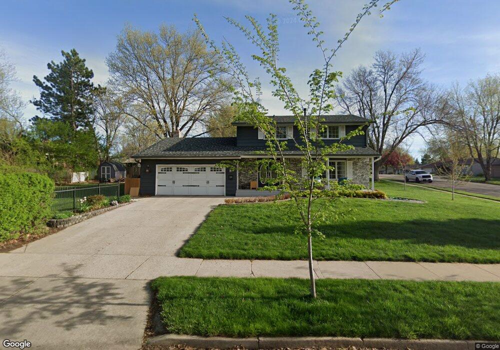
2004 E 52nd St Sioux Falls, SD 57103
Tuthill NeighborhoodEstimated Value: $399,886 - $433,000
4
Beds
4
Baths
2,486
Sq Ft
$169/Sq Ft
Est. Value
About This Home
This home is located at 2004 E 52nd St, Sioux Falls, SD 57103 and is currently estimated at $419,222, approximately $168 per square foot. 2004 E 52nd St is a home located in Minnehaha County with nearby schools including John Harris Elementary School, Patrick Henry Middle School, and Lincoln High School.
Ownership History
Date
Name
Owned For
Owner Type
Purchase Details
Closed on
Oct 21, 2019
Sold by
Simmons Rlt Simmons W and Simmons Rlt Rlt L
Bought by
Jacobs Scott and Jacobs Joelle M
Current Estimated Value
Home Financials for this Owner
Home Financials are based on the most recent Mortgage that was taken out on this home.
Original Mortgage
$147,000
Outstanding Balance
$128,779
Interest Rate
3.5%
Mortgage Type
New Conventional
Estimated Equity
$290,443
Purchase Details
Closed on
Feb 27, 2015
Sold by
Thomas W Thomas W and Simmons Mary L
Bought by
Revo Simmons W and Revo Mary L Simmons
Create a Home Valuation Report for This Property
The Home Valuation Report is an in-depth analysis detailing your home's value as well as a comparison with similar homes in the area
Home Values in the Area
Average Home Value in this Area
Purchase History
| Date | Buyer | Sale Price | Title Company |
|---|---|---|---|
| Jacobs Scott | $307,000 | Stewart Title Company | |
| Revo Simmons W | -- | -- |
Source: Public Records
Mortgage History
| Date | Status | Borrower | Loan Amount |
|---|---|---|---|
| Open | Jacobs Scott | $147,000 |
Source: Public Records
Tax History
| Year | Tax Paid | Tax Assessment Tax Assessment Total Assessment is a certain percentage of the fair market value that is determined by local assessors to be the total taxable value of land and additions on the property. | Land | Improvement |
|---|---|---|---|---|
| 2024 | $5,023 | $366,200 | $35,200 | $331,000 |
| 2023 | $5,204 | $366,200 | $35,200 | $331,000 |
| 2022 | $4,934 | $327,000 | $35,200 | $291,800 |
| 2021 | $4,242 | $254,100 | $0 | $0 |
| 2020 | $4,242 | $268,600 | $0 | $0 |
| 2019 | $3,791 | $234,600 | $0 | $0 |
| 2018 | $3,398 | $224,398 | $0 | $0 |
| 2017 | $3,270 | $210,480 | $33,976 | $176,504 |
| 2016 | $3,270 | $202,383 | $33,976 | $168,407 |
| 2015 | $3,322 | $197,981 | $30,703 | $167,278 |
| 2014 | $3,230 | $197,981 | $30,703 | $167,278 |
Source: Public Records
Map
Nearby Homes
- 4201 S Lewis Ave
- 1904 E 49th St
- 4004 S Otonka Pass
- 4104 S Hackberry Cir
- 4912 S Kalen Place
- 5016 S Winston Ln
- 2512 E Winston Cir
- 1200 E Tomar Rd
- 4505 S Southridge Dr
- 4513 S Southridge Dr
- 2801 E Worcester Place
- 5425 S Salvation Place
- 1604 E 62nd St
- 2716 E Tranquility Place
- 2705 E Tranquility Place
- 2520 E Whisper Trail
- 2401 E Joshua Cir
- 2403 E Joshua Cir
- 2609 E Whisper Trail
- 4500 S Tomar Rd
- 4317 S Chicago Ave
- 2000 E 52nd St
- 4312 S Lewis Ave
- 4313 S Chicago Ave
- 2005 E 52nd St
- 2100 E 52nd St
- 4312 S Chicago Ave
- 2009 E 52nd St
- 2001 E 52nd St
- 2101 E 52nd St
- 4308 S Chicago Ave
- 4309 S Chicago Ave
- 4308 S Lewis Ave
- 4404 S Lewis Ave
- 2104 E 52nd St
- 2105 E 52nd St
- 4405 S Lewis Ave
- 4401 S Lewis Ave
- 4304 S Chicago Ave
- 4309 S Briarwood Ave
Your Personal Tour Guide
Ask me questions while you tour the home.