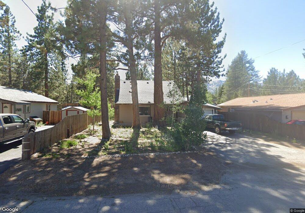
2004 Washoe St South Lake Tahoe, CA 96150
Estimated Value: $491,776 - $537,000
2
Beds
1
Bath
1,196
Sq Ft
$430/Sq Ft
Est. Value
About This Home
This home is located at 2004 Washoe St, South Lake Tahoe, CA 96150 and is currently estimated at $513,944, approximately $429 per square foot. 2004 Washoe St is a home located in El Dorado County with nearby schools including Tahoe Valley Elementary School, South Tahoe Middle School, and South Tahoe High School.
Ownership History
Date
Name
Owned For
Owner Type
Purchase Details
Closed on
Oct 25, 1994
Sold by
Verzi Scott Anthony
Bought by
Grossman Dana
Current Estimated Value
Home Financials for this Owner
Home Financials are based on the most recent Mortgage that was taken out on this home.
Original Mortgage
$77,000
Interest Rate
6.5%
Create a Home Valuation Report for This Property
The Home Valuation Report is an in-depth analysis detailing your home's value as well as a comparison with similar homes in the area
Home Values in the Area
Average Home Value in this Area
Purchase History
| Date | Buyer | Sale Price | Title Company |
|---|---|---|---|
| Grossman Dana | $97,000 | Placer Title Company |
Source: Public Records
Mortgage History
| Date | Status | Borrower | Loan Amount |
|---|---|---|---|
| Closed | Grossman Dana | $77,000 |
Source: Public Records
Tax History Compared to Growth
Tax History
| Year | Tax Paid | Tax Assessment Tax Assessment Total Assessment is a certain percentage of the fair market value that is determined by local assessors to be the total taxable value of land and additions on the property. | Land | Improvement |
|---|---|---|---|---|
| 2025 | $1,738 | $162,883 | $41,969 | $120,914 |
| 2024 | $1,738 | $159,691 | $41,147 | $118,544 |
| 2023 | $1,708 | $156,561 | $40,341 | $116,220 |
| 2022 | $1,690 | $153,492 | $39,550 | $113,942 |
| 2021 | $1,660 | $150,483 | $38,775 | $111,708 |
| 2020 | $1,639 | $148,941 | $38,378 | $110,563 |
| 2019 | $1,630 | $146,022 | $37,626 | $108,396 |
| 2018 | $1,594 | $143,160 | $36,889 | $106,271 |
| 2017 | $1,568 | $140,354 | $36,166 | $104,188 |
| 2016 | $1,536 | $137,603 | $35,457 | $102,146 |
| 2015 | $1,459 | $135,537 | $34,925 | $100,612 |
| 2014 | $1,459 | $132,885 | $34,242 | $98,643 |
Source: Public Records
Map
Nearby Homes
- 1982 Cherokee St
- 1140 Sioux St
- 0 Tomahawk Ln
- 2877 Us Highway 50
- 1940 Apache Ave
- 1935 Apache Ave
- 1085 Mulberry Dr
- 1666 Arapahoe St
- 2182 Lindenwood Dr
- 2181 Pinewood Dr
- 2189 Cornelian Dr
- 1444 Apache Ave
- 1502 Seminole Dr
- 1801 Meadow Vale Dr
- 1675 Arapahoe St
- 1596 Arapahoe St
- 2255 Blitzen Rd
- 2263 Blitzen Rd
- 1344 Ottawa Dr
- 1795 Narragansett Cir
- 2000 Washoe St
- 2008 Washoe St
- 1102 Pueblo St
- 2014 Washoe St
- 2005 Washoe St
- 2001 Washoe St
- 2009 Washoe St
- 1111 Pueblo St
- 2018 Washoe St
- 1997 Washoe St
- 2015 Washoe St
- 1890 Arrowhead Ave
- 1171 Apache Ave
- 1882 Arrowhead Ave
- 1101 Pueblo St
- 1185 Apache Ave
- 1991 Washoe St
- 2021 Washoe St
- 2002 Piute St
- 2008 Piute St